
(details of each turnpike
trust can be reached by clicking on links at bottom of this page)
Somerset
County Topology
Although none of the rivers are large, some
are slow flowing forming extensive marshes.
The county town,
Old Routes through the County
The main
Turnpike Pattern
There then followed a period of infilling
with generally smaller trusts. Several of these seemed to be turnpiking every
highway in the district with no obvious pattern of main roads. Hence in the
south of the
During the early decades of the 19th century many of the trusts obtained powers to build new sections of roads to by-pass inconvenient section of road and improve gradients. In many of these projects they were advised by the McAdam family who were General Surveyors on several of the larger Somerset Trusts (the Bristol Trust had been JL McAdam’s first important post). The Somerset trusts were affected by the arrival of the railways in the 1840s in the north and by the 1850s elsewhere. After a period of steady decline the trusts were progressively wound up in the late 1870s onwards and the roads transferred to local Highway Boards and later the County Council in 1888.
A map of turnpike roads in Somerset gives details of the roads for which individual trusts were responsible.
This
draws primarily on the work of the
(use the list of turnpikes trusts in the main table for more details of individual trusts).
Tollhouses
Click on the highlight to reach a table showing the tollhouses that have been recorded in Somerset. Around 90 of the original 260 still survive in some form; this is a relatively high rate of survivals compared with other counties in the country.
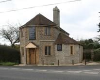 Tollhouse
at Horsington
Tollhouse
at Horsington
Milestones
The majority of milemarkers erected by the
Somerset Turnpike trusts were originally milestones but many trusts attached
metal plates to these in the early 19th century, since this was
generally cheaper than regularly re-engraving the limestone. A few metal
mileposts were erected and a significant number of cast iron Parish Boundary
markers were erected around
. 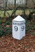 A repainted Milepost on Brown
Down. This series to the Devon border were originally
erected by
A repainted Milepost on Brown
Down. This series to the Devon border were originally
erected by
Individual Turnpike Trusts in Somerset
Documents and notes relating to individual Trusts are summarised on pages reached by clicking the links below (those highlighted in blue are on-line).
Black Dog (Bath and Warminster)
Langport, Somerton and Castle Cary
Trusts
from Other Counties
Trowbridge
The numbers of milestones and tollhouses
surviving beside roads in Somerset
(note this excludes features such
as guidestones and boundary markers and non-road
markers)
|
Turnpike Trust |
Miles of Road in 1840 |
Milestones found |
survival rate |
Main Tollhouses in 1840 |
Tollhouse sites
identified |
Surviving tollhouses |
survival rate |
|
|
51 |
37 |
72% |
17 |
25 |
9 |
53% |
|
Black Dog (Bath
& Warminster) |
30 |
15 |
51% |
7 |
5 |
5 |
71% |
|
Bridgwater |
49 |
16 |
32% |
10 |
6 |
5 |
50% |
|
Bruton |
57 |
19 |
33% |
15 |
13 |
2 |
13% |
|
Chard |
44 |
6 |
14% |
7 |
6 |
3 |
43% |
|
Crewkerne |
28 |
3 |
11% |
12 |
9 |
3 |
25% |
|
Frome |
42 |
15 |
36% |
11 |
11 |
6 |
55% |
|
High Ham and
Ashcott |
10 |
0 |
0% |
3 |
0 |
0 |
0% |
|
Ilchester |
23 |
7 |
30% |
6 |
4 |
1 |
17% |
|
Ilminster |
42 |
13 |
31% |
11 |
14 |
9 |
82% |
|
Langport,
Somerton and Castle Cary |
81 |
18 |
22% |
14 |
16 |
5 |
36% |
|
Martock and |
16 |
5 |
31% |
3 |
2 |
0 |
0% |
|
Minehead Roads |
86 |
4 |
5% |
22 |
31 |
6 |
27% |
|
Radstock |
23 |
9 |
38% |
5 |
5 |
2 |
40% |
|
Shepton Mallet |
52 |
29 |
55% |
16 |
21 |
9 |
56% |
|
|
81 |
9 |
11% |
21 |
13 |
6 |
29% |
|
Wedmore |
15 |
0 |
0% |
4 |
4 |
4 |
100% |
|
Wells |
39 |
13 |
33% |
9 |
14 |
6 |
67% |
|
Wells and
Highbridge |
25 |
0 |
0% |
|
1 |
1 |
|
|
West Harptry inc Chew Magna |
40 |
3 |
8% |
10 |
2 |
1 |
10% |
|
|
7 |
0 |
0% |
|
1 |
|
|
|
Wincanton |
41 |
11 |
27% |
9 |
10 |
2 |
22% |
|
Wiveliscombe |
64 |
4 |
6% |
30 |
10 |
2 |
7% |
|
Yeovil |
26 |
15 |
58% |
10 |
11 |
3 |
30% |
|
Total for |
972 |
251 |
26% |
252 |
234 |
90 |
36% |
|
|
|
28 |
|
|
8 |
5 |
|
|
Honiton
& Ilminster |
|
1 |
|
|
1 |
1 |
|
|
Honiton
|
|
1 |
|
|
2 |
1 |
|
|
Trowbridge |
|
0 |
|
|
2 |
1 |
|
|
Vale
of Blackmoor |
|
0 |
|
|
2 |
1 |
|
|
Sherborne |
|
6 |
|
|
|
|
|
|
Total for
non-Somerset Turnpike Trusts |
|
42 |
|
|
|
|
|
|
non-turnpike |
|
10 |
|
|
|
|
|
For further reading;
Bentley, J.B.
& Murless B.J. (1985)
Bentley, J.B. & Murless B.J. (1987) Somerset Roads – the legacy of Turnpikes – Phase 2 – Eastern Somerset, publ by Somerset Industrial Archaeology Society
Bentley, J.B. & Daniels P. (1990) The Shepton Mallet Turnpike Trust, Somerset Industrial Archaeology Society Bulletin , No 77, pp17-21.
Buchanan
Buchanan
Cameron A (2006)
High Ham and Ashcott Turnpike Trust,
Clarke
This page created by Alan Rosevear 5th
Feb 2009.
Last Edited 11th Feb 2009