This trust, created in
1707, was one of the earliest turnpike trusts in
|
Bath |
|
6 Anne c42 |
1707 |
|
|
Bath |
|
7 Geo1 c19 |
1721 |
|
|
Bath |
Added Claverton Down,
Dunkerton Bridge road and Avon Bridge to Newton |
12 Geo2 c20 |
1739 |
|
|
Bath |
|
30 Geo2 c67 |
1757 |
|
|
|
Amending |
32 Geo2 c51 |
1759 |
|
|
|
Amending |
1 Geo3 c31 |
1761 |
|
|
|
|
33 Geo3 c144 |
1793 |
|
|
Bath & branches |
3 Districts |
50 Geo3 c153 |
1810 |
|
|
Bath & branches |
|
10 Geo4 c110 |
1829 |
1860 |
|
|
Expired |
39 & 40 Vic c39 |
|
1878 |
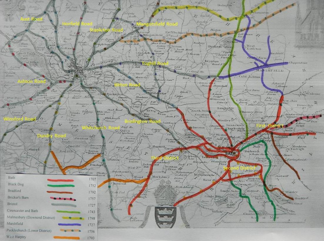
Bath 1829
An Act for amending and otherwise improving several Roads leading into and from the City of Bath, and for making new Branches of Roads to and from the same. [1st June 1829.]
First District, which shall comprise the Road from the Eastward end of the Bridge called Lomb Bridge, in the Parish of Swainswick in the said County of Somerset, through the Parishes of Batheaston and Bathford in the same County, to a Stone set as a Mark where that Line of the Road terminates on the Top of Kingsdown Hill in the said Parish of Box, which shall be called the London Road;
the road leading from Batheaston Bridge on the said London Road to the Cross Roads leading to Colerne, Nettleton, and Marshfield, all lying in the said Parishes of Batheaston and Bathford, and in the Parish of Colerne in the County of Wills, which shall be called the Colerne Road;
the Road leading from the Eastward End of Lansdown Place, in the Parish of Walcot in the said County of Somerset, to the Monument on Lansdown, and from the said Monument to the Cross Roads where the Bath and Bristol Roads unite, which said last-described Roads shall be called the Lansdown and Wick and Abson Roads, and which said Two last-mentioned Roads do lie in the several Parishes of Walcot, Charlcombe, and Weston, in the said County of Somerset, and in the several Parishes of Coldashton, Bitton, Doynton, and Wick and Abson, in the County of Gloucester ;
Second District, which shall comprise the Road leading from the South End of Bath Old Bridge, up the new Road on the North Side of`Holloway, and from thence by a Place called Devonshire Buildings, up the new Road through Barracks Farm, to the White Post in the Parish of Midsomer Norton, where the Bath, Wells, and Shepton Mallett Roads unite, all lying in the several Parishes of Lyncomb and Widcomb, Combhay, Englishcombe, Dunkerton, Wellow, Camerton, Radstoke, Midsomer Norton, Kilmersdon, and Stratton-on-the-Foss, in the said County of Somerset, and the Road leading from the South End of the said Bath Old Bridge, up Holloway, to the Junction with the said last-mentioned Road near the Bear Inn, which shall ,be called the Upper Wells and Holloway Road; the Road leading from the Turnpike called the Holloway or Upper Wells Gate, by Cottage Crescent, to a Lane leading to the Red Lion on Odd Down, which shall be deemed Part of the said Upper Wells Road;
the Road leading from Devonshire Buildings aforesaid, up Entry Hill, to the Warminster and Frome Roads, being in the said Parish of Lyncomb and Widcomb, which shall be called the Warminster and Frome Road; the new Road leading from and out of the said Upper Wells Road to the Junction with the Warminster and Frome Road, all lying in the several Parishes of Lyncomb and Widcomb and South Stoke in the said County of Somerset, which shall be deemed Part of the said Warminster and Frome Road;
the Road leading from the Stone Quarries at the top of Entry Hill, over Comb Down, to the Road leading from Bath to Bradford, lying in the several Parishes of Lyncomb and Widcombe, Claverton and Monckton Combe, in the said County of Somerset, and the Road leading from a Public House called the White Hart, at the Eastward End of Claverton Street in the said Parish of Lyncomb and Widcombe, up Claverton Hill and over Claverton Down, to the Bridge over Comb Brook at the Bottom of Coomb Hill, where the Bath and Bradford Roads unite, all lying in the several Parishes Lyncomb and Widcomb, Claverton and Monckton Combe, in the said County of Somerset, which shall be called the Comb Doom and Claverton and Coomb Hill Roads;
Third District, which shall comprise the Road loading from the South End of the said Bath Old Bridge to the Globe at Newton Saint Loe, and from thence to a Point near the Top of Rush Hill where a Boundary Stone is erected, and there joining the Shepton Mallett Turnpike Road, all lying in the several Parishes of Lyncombe and Widcombe, Twerton, Newton Saint Loe, Corston, Marksbury, Compton Dando, Farmborough, High Littleton, Farrington Gurney, and Stoneaston, in the said County of Somerset, which shall be called the Lower Bristol and Lower Wells Roads;
the Road leading from the Westward Boundary of the City of Bath, near the Road or Way leading to Marlborough Buildings in the said Parish of Walcot, to Combe Brook in the Parish of Kelston, where the Bath and Bristol Roads unite, all lying in the several Parishes of Walcot, Weston, and Kelston in the said County of Somerset, which shall he called the Kelston or Upper Bristol Road; and the Road leading from the Direction Post on the said Kelston Road, near Partis College, over Newton Bridge, to the Turnpike Gate called the Cross Post Gate, communicating with the Lower Bristol and Lower Wells Roads, all lying in the several Parishes of Weston and Newton Saint Loe in the said County of Somerset, which shall be deemed Part of the Kelston or Upper Bristol Road;
also for making and maintaining the several new Branches of Road and the said new line of road herein described, in the said Parish of Bow. Described as;………..
(i)
new
made from a certain Road called the Kelston or Upper
Bristol Road, branching on the South Side thereof from and through a Lane
leading to the Limekilns near Locksbrook in the
Parish of Weston in the County of Somerset, and thence to communicate nearly in
a straight Line, through the Lands of Thomas Leir,
William Purlewent, and John Wiltshire, Esquires, and
others, with the same Road at or near the Bottom of New Bridge Hill, such new
Line being in the said Parish of Weston ;
(ii)
also
from the Road called the Lower Wells Road, branching on the Eastward Side
thereof from a Point nearly opposite the Rectory House in the Parish of Marksbury, in the Occupation of the Reverend George
Seymour, and to Join the same Road leading from Marksbury
to Farmborough on the Westward Side of Marksbury Church, such new Line being in the said Parish of
Marksbury;
(iii)
also
from the said Road called the Lower Wells Road, branching on the South Side
thereof, at or near to the Point where the Timsbury
Road joins the said Lower Wells Road, about Nine Miles and a Half from the City
of Bath, in a Southerly Direction into and through the Lands of Lieutenant
General Popham, Jacob Collins, Henry Tucker, and
others, and to communicate with the said Lower Wells Road at a Point near the
Dwelling House of Walter Gaby, in the Parish of High Littleton, such new Line
being in the said Parishes of Farmborough and High
Littleton ;
(iv)
also
from the Road called the Upper Wells Road, branching on the Eastward Side
thereof from or near·Dunkerton Bridge, and passing on
the South-easterly and South-westerly Sides of the present Road into and
through the Lands of the Mayor, Aldermen, and Citizens of the City of Bath,
Elizabeth Jane Bury, Micah Gibbs, Walter Long Esquire, and others, and to
communicate with the same Road at the Distance of Three Furlongs or thereabouts
above the Five Mile Stone on such Road, such new Line being in the Parish of Wellow ;
(v)
and
also from the Road called the London Road, branching on the North-eastward Side
thereof from or near to the Dwelling House of Roger Western Esquire, in the
Parish of Bathford, into, through,
and across an Orchard and Field belonging to John Briscoe, and there to
communicate with the Turnpike Road leading from Bath to Chippenham,
such new Line being in the said Parish of Bathford :
(vi)
And
whereas, in consequence of the dangerous Steepness of the Hill called Kingsdown Hill, or a Part thereof being on the said Road
called the London Road, it would be of great public Benefit and Utility if a
new Road to avoid the same were made from or near the Bridge near to the Lodge
of John Wiltshire Esquire, in the Parish of Box in the said County of Wills, to
or near or into the Village of Box, and thence up the Box Valley to or near the
Point where the Bradford and Pickwick Roads cross the Road leading from Box to Melksham, such new Line being in the said Parish of Box.
Phillip George of
There are 51 miles 2 furl. of
road through 34 parishes – all repaired by the trustees
17 toll gates and 9 side bars
The roads are stated to be in “generally good” repair – no part under indictment
for want of repair.
In “Return of length of road in each Turnpike
Trust in
Trust reported 52
miles 2 furl. 29 yds (similar to 1840)
(only
a short distance is in “Somerset Roads – the Legacy of Turnpike, by Bentley and
Murless 1985”)
London
Road; A4 eastwards to Batheaston
and then UC road over Kingsdown to Blue Vein.
Colerne Road; UC road NE from Batheaston along old Roman
Road to County boundary.
Lansdown and Wick and Abson Roads; UC road N from Bath over Lansdown, past the Monument to meet A420 at Toghill.
Upper Wells and Holloway Road; A367 from Bath to Old Down through Peasedown St John to White Post nr Chilcompton at jct with B3139. Bath Bridge to Holloway and to Old Down.
Warminster and Frome Road; The A3062 through Widcombe and Combe Hill to Old
down
Comb Doom and Claverton and Coomb Hill Roads; UC road over Combe Down and Claverton Down over A36 to Combe Bridge jct with B3108.
Lower Bristol and Lower Wells Roads; A4 westwards through Twerton to Newton and Corston, then as A39 to through Marksbury and Farrington Gurney and jct with A37 to Shepton.
Kelston or Upper Bristol Road; The A431 through Weston and Kelston to
County Boundary; road through Newbridge to Newton St Loe.
Box Road; A365 from Box to jct with B3109 and Blue Vein road.
Click
here for a map of Bath & Bristol
Turnpike Roads
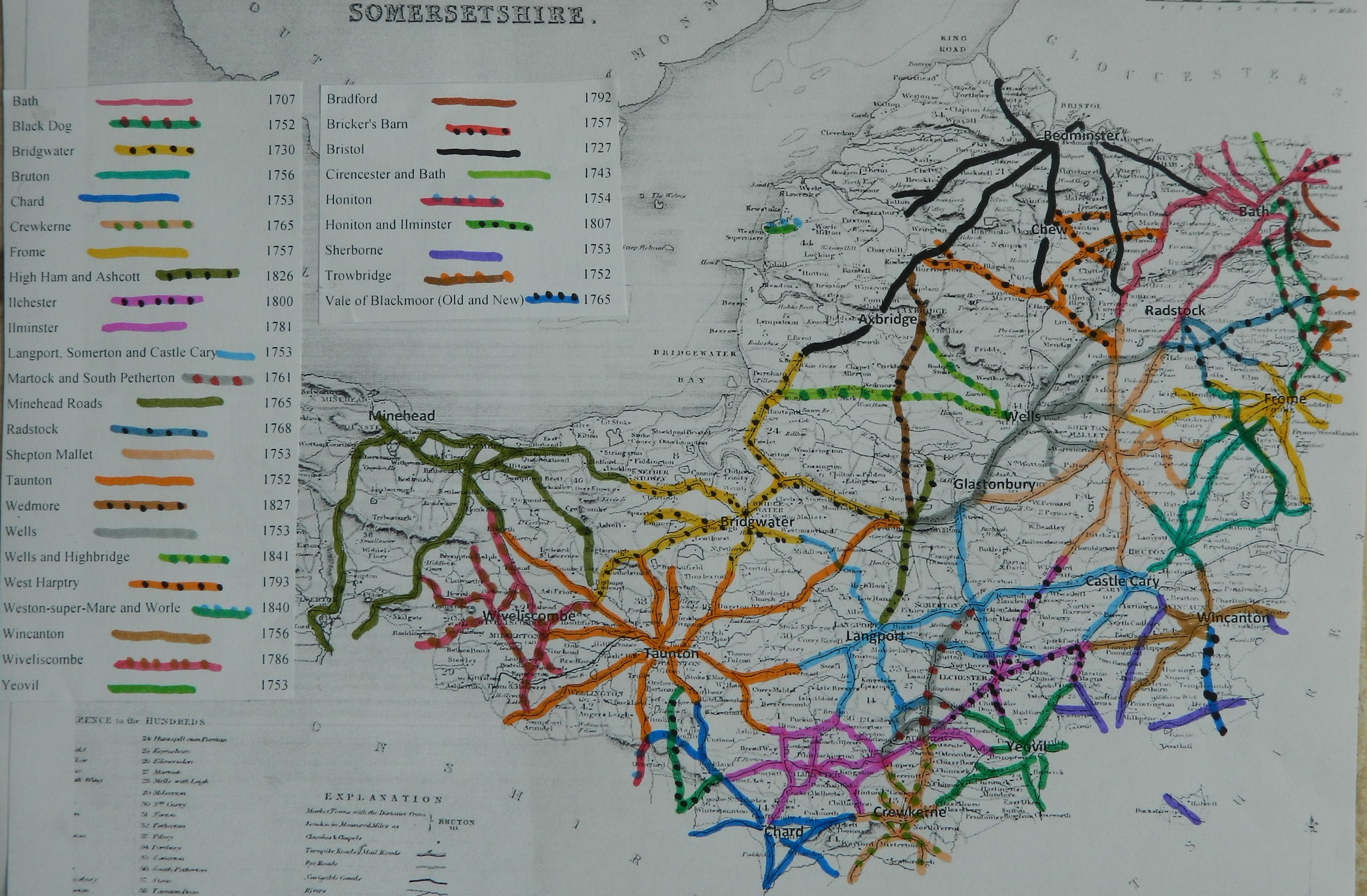
Click
here for a map of Somerset Turnpike Roads
Click
here to return to Turnpikes
Home
Return to Turnpikes in Somerset general page
|
Road
Classification Number |
Route |
GATE NAME |
OS Grid Ref- Prefi |
Easting |
Northing |
District |
Civil Parish |
Location (Name or
Number) |
Road or Street
(see across) |
Position |
Evidence |
Revised 15th Oct
2013 |
erected by
(Turnpike Trust or Authority) |
Bibliographic
refs |
Revised 23rd Sept
2013 |
Old County |
MSS National ID |
|
UC road |
Old Road
from Bath to Radstock |
Bloomfield
Road |
ST |
7442 |
6326 |
AVBS |
BATH |
Westfield
Cottage, No. 150 |
Bloomfield
Road |
at jct with
Englishcombe Lane |
; ; ; |
Bath |
- |
SO |
AV.BAT02 |
||
|
A4 |
Bath to Box |
Grosvenor
(London Road or Walcot) |
ST |
75937 |
66155 |
AVBS |
BATH |
No. 1 |
Balustrade,
Walcot |
at jct with
St Saviour's Road, at end of shops |
;
; Turnpike Trust
Returns 1824; Searle Vol 1. |
Bath |
Dowding J & Taylor P. (2013) The Toll-Houses of Somerset
, p 155; Census 1871 |
SO |
AV.BAT03 |
||
|
UC road |
Bath to Claverton Down |
Bathwick |
ST |
7705 |
6421 |
AVBS |
BATH |
The Round
House |
The Avenue,
top of Bathwick Hill, Claverton
Down |
opp.
Copeland, now in a cul de sac by entrance to
University on the Bath Skyline Trail |
OS 1st Series; ;
; |
Bath |
|
SO |
AV.BAT05 |
||
|
UC road |
Bath to Wick |
Lansdown |
ST |
748 |
660 |
AVBS |
BATH |
Lansdown Road, jct with Richmond Road nr St Thomas
church |
|
; ; Turnpike
Trust Returns 1824; |
Bath |
Dowding J & Taylor P. (2013) The Toll-Houses
of Somerset , p 152; Census 1841 |
SO |
||||
|
A36 |
Bath to Bristol |
Lower Bristol |
ST |
748 |
643 |
AVBS |
BATH |
Lower Bristol
Road; opp Milk Street |
|
|
; ; Turnpike
Trust Returns 1824; |
Bath |
|
SO |
|||
|
A3062 |
Bath to Combe Down |
Combe Down Middle |
ST |
753 |
623 |
AVBS |
BATH |
|
|
|
; ; Turnpike
Trust Returns 1824; |
Bath |
Dowding J & Taylor P. (2013) The Toll-Houses
of Somerset , p 160; Census 1851 |
SO |
|||
|
UC road |
Bath to Combe Down |
Coombe Hill (Brassknocker)
(with Weighing engine) |
ST |
778 |
632 |
AVBS |
BATH |
Coombe Hill, Claverton |
|
|
; ; Turnpike
Trust Returns 1824; |
Bath |
Dowding J & Taylor P. (2013) The Toll-Houses
of Somerset , p 151; Census 1841 |
SO |
|||
|
A367 |
Bath to Radstock |
Holloway (Wells) |
ST |
747 |
640 |
AVBS |
BATH |
Holloway, Bear
Flat |
|
|
OS 1st Series; ;
Turnpike Trust Returns 1824; |
Bath |
Dowding J & Taylor P. (2013) The Toll-Houses
of Somerset , p 162; Census 1841 |
SO |
|||
|
A431 |
Bath to Bitton |
Weston |
ST |
73 |
66 |
AVBS |
BATH |
|
|
|
; ; Turnpike
Trust Returns 1824; |
Bath |
Dowding J & Taylor P. (2013) The Toll-Houses
of Somerset , p 157; Census 1871 |
SO |
|||
|
UC road |
Bath to Claverton Down |
Bathwick |
ST |
755 |
643 |
AVBS |
BATH |
bottom of Widcomb Hill, between basins of canal, Pulteney Road |
|
; ; ; |
Bath |
Dowding J & Taylor P. (2013) The Toll-Houses
of Somerset , p 153 |
SO |
||||
|
A4 |
Bath to Bristol |
Blue Lodge |
ST |
744 |
646 |
AVBS |
BATH |
Upper Bristol
Road |
opp. Walcot Quarry (Park lane jct) |
|
; ; ; |
Bath |
Dowding J & Taylor P. (2013) The Toll-Houses
of Somerset , p 158; Census 1841 |
SO |
|||
|
A3062 |
Bath to Combe Down |
Claverton (Widcombe) |
ST |
753 |
643 |
AVBS |
BATH |
Claverton Street
jct at N end of Lyncomb Hill |
|
; ; ; |
Bath |
Dowding J & Taylor P. (2013) The Toll-Houses
of Somerset , p 154; Census 1871 |
SO |
||||
|
A4 |
Bath to Bristol |
Park Farm |
ST |
743 |
651 |
AVBS |
BATH |
Marlborough Lane
jct with Upper Bristol Road |
|
; ; ; |
Bath |
Dowding J & Taylor P. (2013) The Toll-Houses
of Somerset , p 156; Census 1871 |
SO |
||||
|
A36 |
Bath to Bristol |
Twerton (Bristol) |
ST |
744 |
646 |
AVBS |
BATH |
Lower Bristol
Road |
demolished mid 20th cent |
|
; ; ; |
Bath |
Dowding J & Taylor P. (2013) The Toll-Houses
of Somerset , p 158; Census 1841 |
SO |
|||
|
A4 |
Bath to Box |
Bath Easton |
ST |
781 |
675 |
AVBS |
BATHEASTON |
London Road jct
with Bannerdown Road |
|
|
; ; Turnpike
Trust Returns 1824; |
Bath |
Dowding J & Taylor P. (2013) The Toll-Houses
of Somerset , p 150; Census 1841 |
SO |
|||
|
A37 |
Bristol to Shepton Mallet |
White Cross
(with Weighing engine) |
ST |
6292 |
5685 |
AVBS |
CLUTTON |
Turnpike
Cottage |
White
Cross, Wells Road, Hallatrow |
at jct with
A39 to Hallotrow and Bath, between Temple Cloud and
Farrington Gurney |
; ; ; |
Bath |
Dowding J & Taylor P. (2013) The Toll-Houses of Somerset
, p 163; Census 1861 |
SO |
AV.CLU |
||
|
A367 |
Bath to Radstock |
Burnthouse (Odd Down) |
ST |
734 |
618 |
AVBS |
COMBE HAY |
Vernham Wood jct on Odd Down |
|
|
OS 1st Series; ;
; |
Bath |
Dowding J & Taylor P. (2013) The Toll-Houses of Somerset
, p 163; Census 1871 |
SO |
AV.COM |
||
|
A39 |
Bath to
Wells |
Corston |
ST |
66847 |
64015 |
AVBS |
CORSTON |
Two Headed
Man (Corston Motors) |
Wansdyke |
at jct with
B3116 to Keynsham |
; ; ; |
Bath |
Dowding J & Taylor P. (2013) The Toll-Houses of Somerset
, p 161; Census 1851 |
SO |
AV.COR |
||
|
A367 |
Bath to Radstock |
Severcombe |
ST |
719 |
608 |
AVBS |
ENGLISHCOMBE |
Severcombe store house at jct opp
large stone house |
|
; ; ; |
Bath |
|
SO |
AV.ENG |
|||
|
A431 |
Bath to Bitton |
Kelston |
ST |
70 |
67 |
AVBS |
KELSTON |
|
|
|
; ; Turnpike
Trust Returns 1824; old ticket |
Bath |
|
SO |
|||
|
A39 |
Bath to Wells |
Marksbury |
ST |
666 |
625 |
AVBS |
MARKSBURY |
|
demolished 1960s |
|
; ; Turnpike
Trust Returns 1824; |
Bath |
Dowding J & Taylor P. (2013) The Toll-Houses
of Somerset , p 162; Census 1871 |
SO |
|||
|
A4 |
Bath to Bristol |
Cross Post |
ST |
714 |
656 |
AVBS |
NEWTON ST LOE |
|
S of Newton
Bridge |
demolished 1967 |
; ; Turnpike
Trust Returns 1824; |
Bath |
Dowding J & Taylor P. (2013) The Toll-Houses
of Somerset , p 159; Census 1871 |
SO |
|||
|
UC road
(was A367) |
Bath to Shepton Mallet |
Red Post |
ST |
69827 |
57145 |
AVBS |
PEASEDOWN
ST JOHN |
Old Red
Post Bakery |
Bath Road,
jct with Whitebrook Lane, Red Post |
opp. Red
Post Inn |
; ; ; |
Bath |
Dowding J & Taylor P. (2013) The Toll-Houses of Somerset
, p 160; Census 1871 |
SO |
AV.PEA |
||
|
A4 |
Bath to Box |
Bailbrook |
ST |
769 |
668 |
AVBS |
SWAINSWICK |
E of jct with
Fosse - dated 1830 |
|
|
;
; ; Searle Vol 1. |
Bath |
Dowding J & Taylor P. (2013) The Toll-Houses
of Somerset , p 154; Census 1871 |
SO |
|||
In the Milestone
Society Database, 39 milestones are identified along this road, mostly on the
A4, A39 and A367, several in designs referred to as Bath Plate and the Bath Guildhall
Plate. There are several particularly striking terminus plates with distinctive
hands indicating the way to Bath. Based on the mileage reported by the Trust in 1840,
would expect 51.