This trust was created
in 1752 as a town centred trust. Its main responsibilities were (a) a section
of the main post road running to the Devon border (b) main feeder roads for routes
through mid-Somerset towards Devon (c) a network of roads leading into the
market town from west
25 Geo II Parl 4 Sess 5; A 1751-52
A Petition for a bill to repair roads
leading from
A petition of the principal inhabitants, gentlemen, clergy and freeholders, residing in or near, the town of Taunton, in County of Somerset, whose names are thereto subscribed was presented to the house and read setting forth ; That the highways leading from Taunton thru the parishes of Taunton St James, Staplegrove and Norton Fitzwarren and Bishops Liddeard to Handy Cross in the Parish of Liddeard St Lawrence;
And also the Highway leading from
And Highway from
And highway from Maddocks Tree in Parish of Thorne Faulcon thru North Curry and Tything of Stoke and Curry Mallett to the Red Post in the Parish of Fivehead;
And Highway from the Quacker’s Burying Ground in Parish of Westmonkton thru Parish of Crech St Michael to the Green Dragon in Parish of Thurloxton;
And Highway from Walford Inn in Parish of
And Highway from Taunton thru Wilton and Bishops Hull by the church and the Parish of Trull, Bradford and West Buckland and Wellington to White Ball in Parish of Sampford Arundell;
And Highway from The New Angel in Taunton thru Parish of Wilton, Trull and Pitminster over Bleigdon Hill to the beginning of Trickey Warren in Parish of Church Taunton (Devon)
And Highway from
And Highway from Taunton St James thru Kingstone to the corner of Mr Coles Wall in Parish of Broomfield and from Row Barton in Parish of Taunton St James thru Parish of Cheddon, Fitzpaine and Kingstone before Hestercombe Park Gate and from thence to the Directing Post beyond Yards Barn in Parish of Broomfield
Are become so ruinous and bad in the winter season that the same cannot, by the ordinary course appointed by Laws and statutes of this realm, be sufficiently repaired and amended without the further assistance of Parliament; and therefore to the end that the said highways may be well an efficiently repaired and amended and kept in good and sufficient repair for the safety of all his Majesty’s subjects whose business requires their travel thru the said highways leave to bring a bill
rept 10; read 27; committee 3 Feb
Petition of Samuel Walker of Burlescombe (Devon) and others, landowners, farmers and occupiers of land in Devon and Somerset; and carriers of Culm and Abbey coal used for burning of lime in those parts; set forth that not only in the neighbourhood of Burlescombe ( 11 miles west of Taunton) but for an extent of many miles and especially to West and South, the lands are chiefly manured with lime and that large tracts of that county will receive no benefit from any other manure and that the occupiers are for the most part supplied therewith from certain kilns in Burlescombe and neighbouring parishes, belonging to Samuel Walker, where there is a vast rock of limestone and that the fuel used in burning the lime is a species of coal, or mineral, called Culm, alone or mixture with other coal, and then called Abbey Coal, both imported from Wales to Bridgewater and from thence conveyed up the River Tone to a place called Ham Mills, but the greatest part is carried on to Taunton, from which places it is brought by single horses to the kiln; and the consumption of Culm, in burning the lime at those kilns is so extraordinary that it furnishes continual employment for more than a hundred farmer, keeping the drifts of horses, and renting estates of different values in that neighbourhood, solely for the purpose; who being thus constantly employed, bring it from Taunton at so low prices as 9d and 10.5d, according to the distance of the several kilns, for each horseload, with a small addition for what is bought from Ham Mills, which lie beyond Taunton, and by such means only are enabled to pay their rents; and that these kilns are situate at the distance of between 2 or 3 miles from the Great Road leading from Taunton, by in the said Culm pass; and that the way from that road to the said kilns is craggy, that it is incapable of any other conveyance.
In case of bill being passed, any tolls or duty should be payable for horses or beasts carrying Culm and Abbey coals it would be impossible for the carriers to continue bringing it at the present prices and if they should be raised (which the nature of the business will barely admit) of consequence the price of lime must be enhanced and a great discouragement ensue to the improvement of lands in these parts.
And alleging that any increase in the great expense that the occupiers are obliged to be for this manure
Petitioners pray for relief
com 7 – all who come to have voices 10;
rept 17; Committee found allegations true and amended the bill – exempting horses carrying Culm from tolls
ingrossed 19; passed 27; lords 5 mar; Royal Ascent 26.
|
|
|
25 Geo2 c54 |
1752 |
|
|
|
|
18 Geo3 c97 |
1778 |
|
|
|
|
39 Geo3 |
1799 |
|
|
|
|
57 Geo3 |
1817 |
1838 |
|
|
|
|
|
|
|
|
Expired |
|
|
1875 |
An Act for
altering, enlarging, and repealing some of the Provisions in an Act, passed in
the Eighteenth Year of the Reign of His present Majesty, for repairing several
Roads leading from the Town of Taunton, and other Roads adjoining thereto, in
the County of Somerset; and also for extending the Provisions of the said Act,
to a Road from Tucker's Gate, in the Parish of Lyng, to Piper's Inn, in the
Parish of Ashcott, in the said County of Somerset. [13th June 1799.]
William Kinglake of
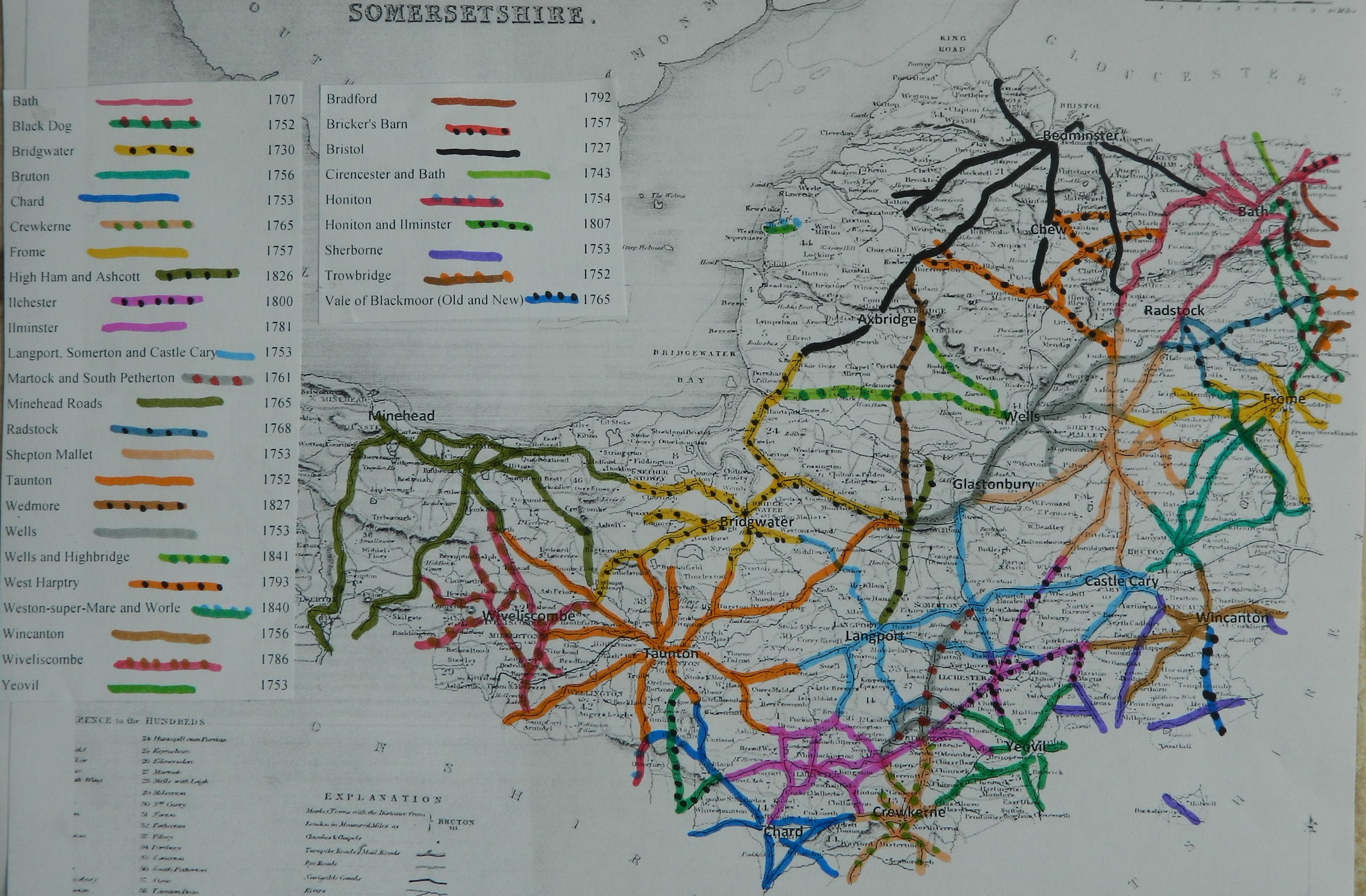
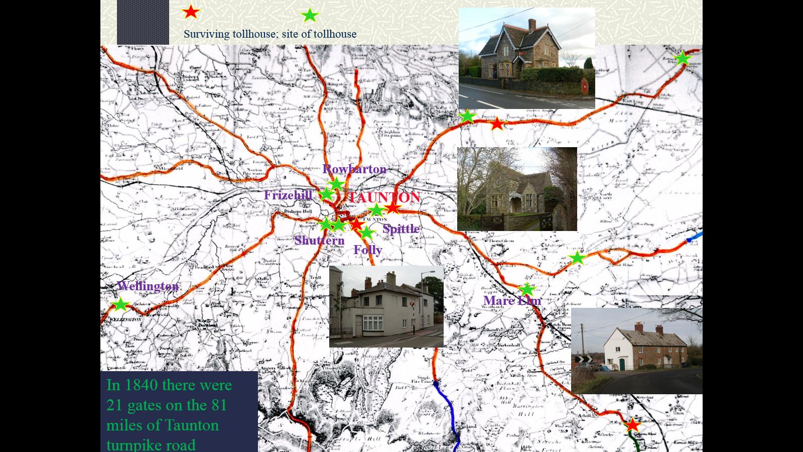
There are 81 miles of road through 45 parishes – all repaired by the
trustees, except for 12 miles 3 furl repaired by parishes
21 toll gates and 1 side bar
The roads are stated to be in “good” repair – no part under indictment
for want of repair.
In “Return of length of road in each Turnpike
Trust in
Trust reported 78
miles 6 furl. 0 yds (2 miles less than in 1840)
List of Roads
(roads identified and mapped in “Somerset Roads
– the Legacy of Turnpike, by Bentley and Murless 1985”)
Click
here for a map of Somerset Turnpike Roads
Click
here for a map of Taunton Turnpike Roads
Click
here to return to Turnpikes
Home
Return to Turnpikes in Somerset general page
|
Road
Classification Number |
Route |
GATE NAME |
OS Grid Ref-
Prefi |
Easting |
Northing |
District |
Civil Parish |
Location (Name or
Number) |
Road or Street
(see across) |
Position |
Evidence |
Revised 23rd Sept
2013 |
|
A361 |
Ashcott to Taunton |
Piper's Inn |
ST |
42 |
36 |
SOSG |
ASHCOTT |
nr Pedwell
Brewery, Pipers Inn (proposal 1824) |
|
; ; 1865 acounts;
|
||
|
A361 |
Taunton to Street |
Greylakes Foss |
ST |
403 |
354 |
SOSG |
GREINTON |
Greylake Foss |
(on other side of
road to promising cottage restored beside old Greylakes pub) |
OS 1st Series; ;
toll advert 1822; 1865 acounts; |
||
|
Taunton to Street |
Peddle Drove |
ST |
4 |
4 |
SOSG |
GREINTON |
?? |
|
|
; ; toll advert
1822; |
||
|
A361 |
Taunton to Street |
Blindman's |
ST |
385 |
321 |
SOSG |
OTHERY |
Kings Sedgemoor ,
jct of road to Middlezoy & Bridgwater |
|
OS 1st Series; ;
1865 acounts, Survey book; |
||
|
A361 |
Taunton to Street |
Burrowbidge |
ST |
3573 |
3041 |
SOTA |
BURROWBRIDGE |
edge of the
levels |
|
|
; ; toll advert
1822; 1865 acounts; |
|
|
A378 |
Taunton to
Langport |
Wrantage |
ST |
319 |
231 |
SOTA |
CURRY MALLET |
Wrantage, Newport
turn |
|
|
; ; 1865 acounts;
|
|
|
A361 (was
on A38) |
Taunton to
Street |
Walford |
ST |
29068 |
28060 |
SOTA |
DURSTON |
May Tree
Cottage |
Main
Street, Higher Durston, opp. Church (was moved from Walford Cross) |
at the
cross roads in the centre of the village (was at ST 282 282) |
OS 1st
Series; ; 1865 acounts; |
|
|
A358 |
Taunton to
Ilminster |
Chapland |
ST |
302 |
189 |
SOTA |
HATCH BEAUCHAMP |
Capland |
|
|
; ; Inspector's
Book 1819; |
|
|
UC road
(was A38) |
Wellington
to Tiverton |
White Ball
or Beam Bridge |
ST |
1082 |
1933 |
SOTA |
SAMPFORD
ARUNDEL |
Sampford
Gate |
Beam Bridge
(cut off section of Pinksmoor Lane) |
back up old
section of road from the large PH, north of the railway bridge and at old
road junction |
OS 1st Series;
Greenwood Devon (1827); 1865 acounts; |
|
|
B3170 |
Taunton to
Corfe |
Silver
Street |
ST |
2321 |
2427 |
SOTA |
TAUNTON |
Toll House,
No.59 |
Silver
Street |
attached to
large town house, beside pedestrian crossing |
; ; 1865
acounts; |
|
|
UC road |
Taunton to
Bridgewater |
Spittle
(East) |
ST |
2482 |
2493 |
SOTA |
TAUNTON |
The Old
Turnpike |
Bridgwater
Road |
was at
Splat Farm (minor jct ST 243 248)) |
OS 1st
Series; ; toll advert 1822; 1792 accounts; 1865 accounts; |
|
|
UC road (was A38) |
Wellington to
Taunton |
Shuttern (South) |
ST |
2228 |
2421 |
SOTA |
TAUNTON |
Shuttern
roundabout |
assume the actual
TH was at the jct of Trull Road and Wellington Road; trustees met in what
became Ete Hospital |
; ; toll advert
1822; 1792 accounts; 1865 accounts; survey book; |
||
|
B3170 |
Taunton to
Shoreditch |
Folly |
ST |
234 |
240 |
SOTA |
TAUNTON |
South Road |
|
|
; ; toll advert
1822; 1792 accounts; 1865 accounts; |
|
|
UC road |
Taunton to
Kingston St Mary |
Rowbarton |
ST |
2205 |
2549 |
SOTA |
TAUNTON |
Staplegrove |
junction of
Staplegrove Road and Chip Lane. |
|
; ; toll advert
1822; 1792 accounts; 1865 accounts; |
|
|
UC road |
Taunton to Holway |
Holway |
ST |
24 |
24 |
SOTA |
TAUNTON |
Holway Road |
|
|
; ; 1792
accounts; |
|
|
UC road |
|
Wild Oak (South) |
ST |
23 |
24 |
SOTA |
TAUNTON |
Mountway |
|
|
; ; 1865 acounts;
|
|
|
UC road (was A38) |
Wellington to
Taunton |
Quaker's Burial
Ground |
ST |
248 |
248 |
SOTA |
TAUNTON |
Quaker's Burial
Ground at jct of Bridgwater and Langport Roads |
|
; ; 1865 acounts;
|
||
|
A358 |
Taunton to
Minehead |
Langford
(Staplegrove) |
ST |
20 |
27 |
SOTA |
TAUNTON |
Langford |
|
|
; ; 1865 acounts;
|
|
|
UC road |
Taunton to
Milverton |
Frizehill (or
Fairwater) |
ST |
220 |
255 |
SOTA |
TAUNTON |
Frieze Hill (S of
Staplegrove) |
|
|
; ; toll advert
1822; 1792 accounts; 1865 accounts; survey book; |
|
|
UC road (was A38) |
Wellington to
Taunton |
Wellington |
ST |
146 |
214 |
SOTA |
WELLINGTON |
Cade's Farm |
|
|
OS 1st Series; ;
toll advert 1822; 1865 accounts; |
|
|
UC road (was
A358) |
Taunton to
Ilminster |
Mare Elm |
ST |
295 |
218 |
SOTA |
WEST HATCH |
Meare Elm Cross |
|
|
; ; toll advert
1822; 1792 accounts; |
|
In the Milestone Society
Database, only 9 milestones are identified along this road, mostly on the
A361 and UC roads, most in a designs referred to as