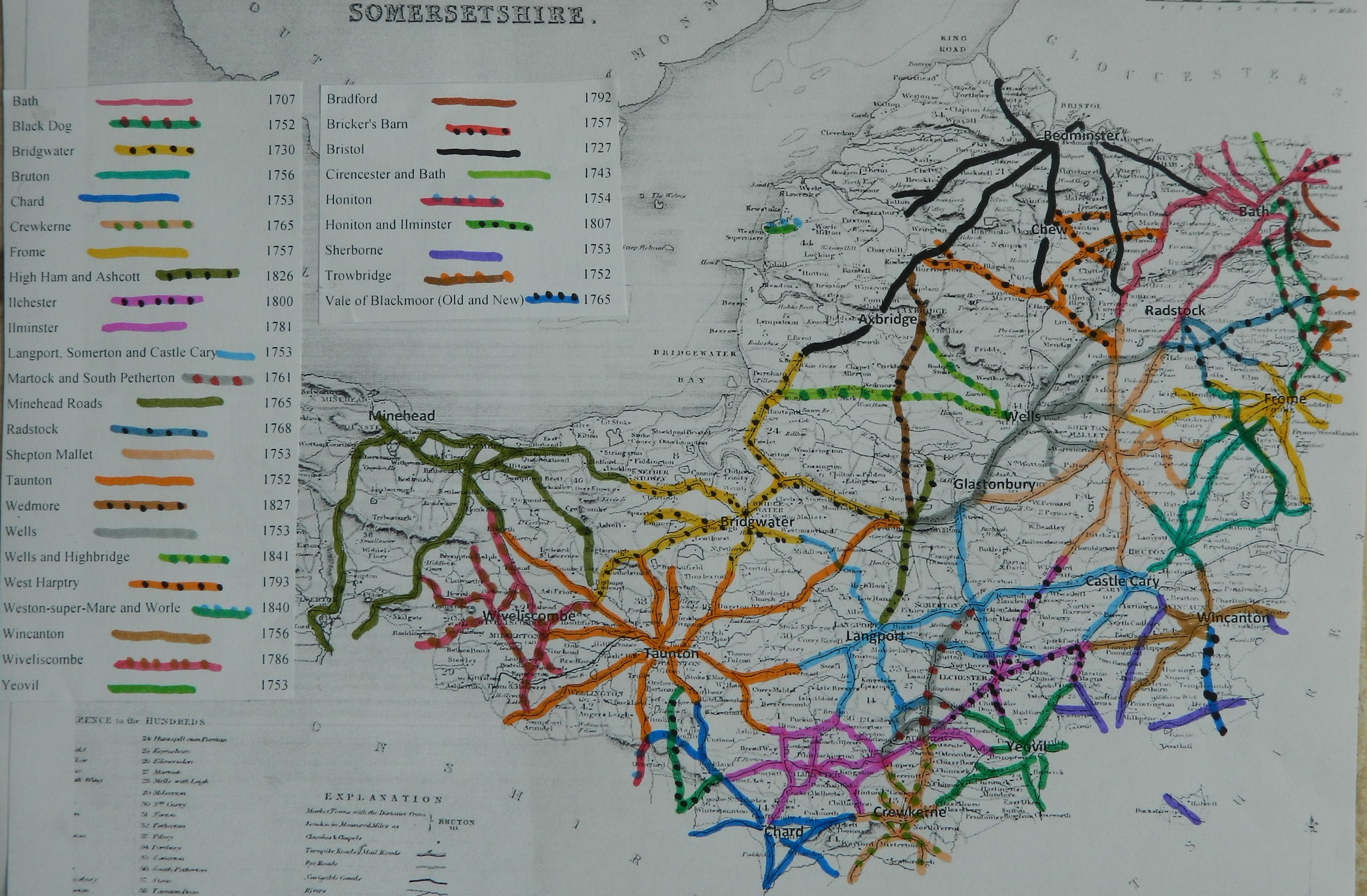
The main post road
through Chard was included in the 1753 Act, turnpiking the road from Lower
Compton, to the east of Sherbourne, through Chard to Axminster. The Somerset
part of the road was administered a Division of the Trust and became an
independent Trust in 1776, when roads radiating to the North and West of Chard
were added. The roads around Crewkerne formed a new Trust in 1829, when a further
road to the SE was added to the Chard Trust. Thus it progressed from a simple
main road trust to be become a town centred network of roads. Its main
responsibilities were (a) the western section of the Post Road through
mid-Somerset and (b) a network of roads radiating from the market town into SW
Somerset and Devon.
Petition relating to Sherborne Road Act
1753 March 6th ;
Petition of the gents clergy and
freeholders residing near the town of
That petitioners are apprehensive such roads are not intended to be included; they are the general post road thru the town of Chard, but intended to be thru a village in the Parish of Chard called Perry Street and that road thru Perry Street is not more than a mile and a quarter nearer than thru Chard and that the present goodness and breadth of the road thru the town (the roads being for the most part wide enough already without purchasing any ground) and the convenience of having all materials necessary for repair immediately on the spot, would make full amends for this small difference and might put in good repair at less expense than the road through Perry Street, for which ground must be purchased for widening the road for the space of several miles and that should a turnpike be erected and the road carried thru Perry St, the petitioners apprehend the same will be attended with extreme bad consequences to petitioners of Chard and that intended road should be thru Chard being the general post road from London to Exon
f to C 6; Report and instruction to make provision 8 ;
In support of 2 allegation;
Mr Simon Bradford and George Warry said that a large market is held a Chard and that a great trade in Woollen Manufactures is carried on in and about the town and that Chard stands on the Great Post Road from London to Exeter, Plymouth and Falmouth that the Perry Street is a mile and quarter from Chard and that the soil of the said roads thru Perry Street is chiefly clay and materials for repairing road are some distance and for considerable way it is not above 7, 8 or 12 feet wide and that road thru Chard is considerably wider and may be effectually widened and repaired for £250 less than Perry Street road
For the Second allegation Mr Andrew Nappier
and John Newman were examined and said, that the roads from Ilminster to
Bill report 17 Mar passed 23 Lors 30 Royal ascent 17 Apr 5
(The original plan was
to use the old Fosse way to the SE of Chard (the road selected by Ogilby in his
1675 map), but this petition was successful in bringing the turnpike road
through the town)
|
Sherborne |
Created as part
of Sherborne to Axminster road |
26 Geo2 c60 |
1753 |
|
|
Chard |
Splits into 2
Divisions |
17 Geo3 |
1776 |
|
|
|
Improving the
route around Street Ash |
40 Geo3 c93 |
1800 |
|
|
|
New route to
Upottery on Honiton Ilminster road |
55 Geo3 c60 |
1815 |
|
|
|
Removal of
Crewkerne Roads and adding road to Winsham |
10 Geo4 |
1829 |
1860 |
|
|
correction |
11 Geo4 |
1830 |
1860 |
|
|
Expired |
|
|
1875 |
Chard
1800
An Act for
repealing Two Acts, one made in the Twenty-sixth Year of the Reign of King George
the Second, and the other in the Seventeenth Year of the Reign of His present
Majesty, for repairing the Road from the Halfway House, in the Parish of Lower
Compton, in the County of Dorset, through the Towns of Yeovil, Crewkerne, and
Chard, to the East End of the Town of Axminster, in the County of Devon, and
several other Roads therein mentioned; and also for repealing so much of an
Act, made in the Eighteenth Year of the Reign of His present Majesty, for
repairing several Roads leading from the Town of Taunton, in the County of
Somerset, as relates to repairing the Road from the Direction Post in Widcombe
Moor, through Street Ash Lane to Chard, and for making more effectual Provision
for those Purposes; and for altering and diverting certain Parts of the said
Roads. [20th June 1800.]
Chard
1815
An Act for
repealing an Act of His present Majesty, for the Repair of several Roads in the
Counties of Somerset, Devon, and Dorset, leading to the Town of Chard, in the
County of Somerset; and for making and repairing a Road from Chard to the
Honiton Turnpike Road, in the Parish of Upottery, in the County of Devon, and
for more effectually repairing the Residue of the Roads comprised in the said
Act. [25th May 1815.]
divided into Two Districts called
" The First District" and " The Second District," which
said Second District comprises the Road
leading from Hasleborough Bridge in the County of Somerset,
through the Towns of Crewkerne and Chard, through a certain
Lane called Stoney Lane to the East End of the Town of Axminster, in the Country of Devon, and
the Roads from the West End of the said Town of Chard, to the Honiton
Turnpike Road at Cheeseway Ash, and from Whitedown in the
County of Somerset, through Perry Street, to Tytherleigh Inn in the County of Dorset, and also the Road
from the Red Lion Corner
in Chard aforesaid, to Street
Ash Lane in the Parish of Combe Saint Nicholas, and
from hence through the several Parishes of Combe Saint Nicholas, Buckland
Saint Mary, Bickenhall, Curland, and Staple Fitzpaine, in the County
of Somerset, to the Taunton Turnpike Road at Staple Pound, in the said Parish of Staple Fitzpaine :
And whereas the Road leading from the West End
of the Town of Chard, in the County of Somerset, to the Honiton
Turnpike Road at Cheeseway Ash, in the County of Devon, being
Part of the Roads comprised in the said
Second District, is very hilly, and in some Places narrow and
incommodious ; and it would greatly facilitate and improve the Communication between the Towns of Chard
and Honiton and the adjoining Places, and also be of public Utility,
if the Course or Direction of the said Road were diverted and made to pass
through the several Parishes of Chard and Combe Saint Nicholas in
the County of Somerset, Wambrooke and Chardstock in the County of Dorset,
and Yarcombe and Upottery in the County of Devon, to
join the present Turnpike Road leading from Honiton to Ilminster,
at or near a certain Place called Rawridge Hill in the said
County of Devon : And whereas it is expedient that the said recited Act,
so far as it relates to the Roads comprised in the said Second District, should be repealed, and that Provision should be
made for amending, widening, altering, and keeping in Repair the same
Roads (except that from the Weft End of the Town of Chard aforesaid, to
the Honiton Turnpike Road at Cheeseway Ash aforesaid, from the
Repairs of which it is proposed the
Trustees of this Act should be discharged) and for making, amending,
widening, and keeping in Repair a Road from the Weft End of the Town of Chard aforesaid, through the several
Parishes of Chard, Combe Saint
Nicholas, Wambrooke, Chardstock, Yarcombe, and Upottery,
aforesaid, to join
the present Turnpike Road from Honiton to Ilminster, at or near Rawridge
Hill aforesaid, in lieu of the Road so intended to be discontinued :
Chard
1829
An Act for more
effectually repairing and improving several Roads which lead to and through the
Town and Borough of Chard in the County of Somerset; and for making and
maintaining a new Road from Chard to Drempton in the County of Dorset. [22d May
1829.]
Chard 1830
An Act for
amending an Act of the last Session, intituled An Act for more effectually
repairing and improving several Roads which lead to and through the Town and
Borough of Chard in the County of Somerset, and for making and maintaining a
new Road from Chard to Drempton in the County of Dorset; and for making and
maintaining other Roads communicating with the said Roads in the Counties of
Somerset, Devon, and Dorset. [29th May 1830.]
Charles Benjamin Tucker of Chard (clerk to the trust) reported
There are 43 miles 4 furl. of road through ? parishes – all repaired by
the trustees (except about a mile in Chard)
7 toll gates and 4 side bars
The roads are stated to be in “fair” repair excepting the road towards
Bridport which is insufficient width, but there is much required to be done– no
part under indictment for want of repair.
In “Return of length of road in each Turnpike
Trust in
Trust reported 43
miles 3 furl. 44 yds (similar to 1840)
(Road identified and mapped in “Somerset Roads
– the Legacy of Turnpike, by Bentley and Murless 1985”)
A30 from Devon border to Lady’s down
A358 from Axminster (Devon) to Chard
B3167 from
Devon border to A30 on White down
B3162 Chard to Greenham
Sections of several
minor roads radiating from Chard and off A30
Click
here for a map of Somerset Turnpike Roads
Click
here to return to Turnpikes
Home
Return to Turnpikes in Somerset general page
|
Road
Classification Number |
Route |
GATE NAME |
OS Grid Ref-
Prefi |
Easting |
Northing |
District |
Civil Parish |
Location (Name or
Number) |
Road or Street
(see across) |
Position |
Evidence |
erected by
(Turnpike Trust or Authority) |
Revised 23rd Sept
2013 |
|
UC road |
Chard to
Combe St Nicholas |
Crimchard |
ST |
31777 |
09384 |
SOSS |
CHARD TOWN |
Turnpike
Cottage |
Crimchard,
jct with Catchgate Lane |
opp. Bew
Lane |
; ;
Turnpike Trust Returns 1824; advert for lease of tolls 1826.; |
Chard |
|
|
UC road |
Street Ash to
Staple Fitzpaine |
Curland |
ST |
27 |
17 |
SOTA |
CURLAND |
assume at jct
where road diverted |
|
|
; ; Turnpike
Trust Returns 1824; |
Chard |
|
|
A30 |
Yeovil to
Crewkerne |
Eastham's |
ST |
45624 |
10652 |
SOSS |
MERRIOTT |
Eastham's
Gate Farmhouse |
Yeovil Road |
on open
road, west of Haselbury Plucknett |
OS 1st
Series; ; ; |
Chard |
|
|
A30 |
Yeovil to
Crewkerne |
Haselbury |
ST |
458 |
109 |
SOSS |
MERRIOTT |
Haselbury Old
Bridge was original terminus of Chard Trust - transferred to Crewkerne in
1825. |
Two gates shown
on OS; this was replaced by Easthams Gate in 1831 but both shown? |
OS 1st Series; ;
Turnpike Trust Returns 1824; advert for lease of tolls 1826.; |
Chard |
||
|
A30 |
Crewkerne to
Chard |
Lady's Down |
ST |
38 |
09 |
SOSS |
WEST CREWKERNE |
Lady's Down is
mentioned as terminus of Chard trust in 1829 |
|
; ; ; |
Chard |
||
|
A30 |
Crewkerne to
Chard |
Roundham |
ST |
425 |
096 |
SOSS |
WEST CREWKERNE |
this section was
originally Chard Trust but transferred to Crewkerne in 1825. |
|
; ; Turnpike
Trust Returns 1824; |
Chard |
||
|
A30 |
Chard to
Honiton |
Snowdon |
ST |
31282 |
08710 |
SOSS |
CHARD TOWN |
Turnpike
Cottage |
Snowdon
Hill, High Street |
jct with
Lower Wambrook Road |
OS 1st
Series; ; Turnpike Trust Returns 1824; advert for lease of tolls 1826.; old
picture |
Chard |
|
|
UC road |
Birdsmoor
Gate to Chard |
Thorncombe
Thorne |
ST |
37240 |
02924 |
DOWD |
THORNCOMBE |
Turnpike
Cottage |
High Street |
crossroads
SW of village |
; ; ; |
Chard |
|
|
A358 |
Axminster to
Chard |
Tytherleigh |
ST |
318 |
033 |
DVED |
CHARDSTOCK |
Tytherleigh |
Broom Lane jct |
old postcard
shows simiar to Snowdon Hill in design |
; ; ; old picture |
Chard |
|
|
A358 |
Axminster to
Chard |
Weycroft |
ST |
305 |
996 |
DVED |
AXMINSTER |
Chard Road |
Weycroft at jct
with Lodge Lane |
Now open area
beside old mill buildings; Greenwood map puts it between Millbrook and
Avoncroft Mill |
; Greenwood Devon
(1827); Turnpike Trust Returns 1824; advert for lease of tolls 1826.; |
Chard |
|
|
A30 |
Crewkerne
to Chard |
Windwhistle |
ST |
3832 |
0967 |
SOSS |
CUDWORTH |
Toll House |
Crewkerne
Road |
E of
Windwhistle PH, opp. London Lodge Farm |
; ;
Turnpike Trust Returns 1824; |
Chard |
|
In the Milestone
Society Database, 6 milestones are identified along this road, mostly on the
A30, A358 and B3162, most in a designs referred to as Chard Tombstone. Based on the mileage
reported by the Trust in 1840, would expect 44.