This trust was created in 1768 as a town-centred network. It was often
referred to as the Buckland Dinham Trust until 1830. Its main responsibilities
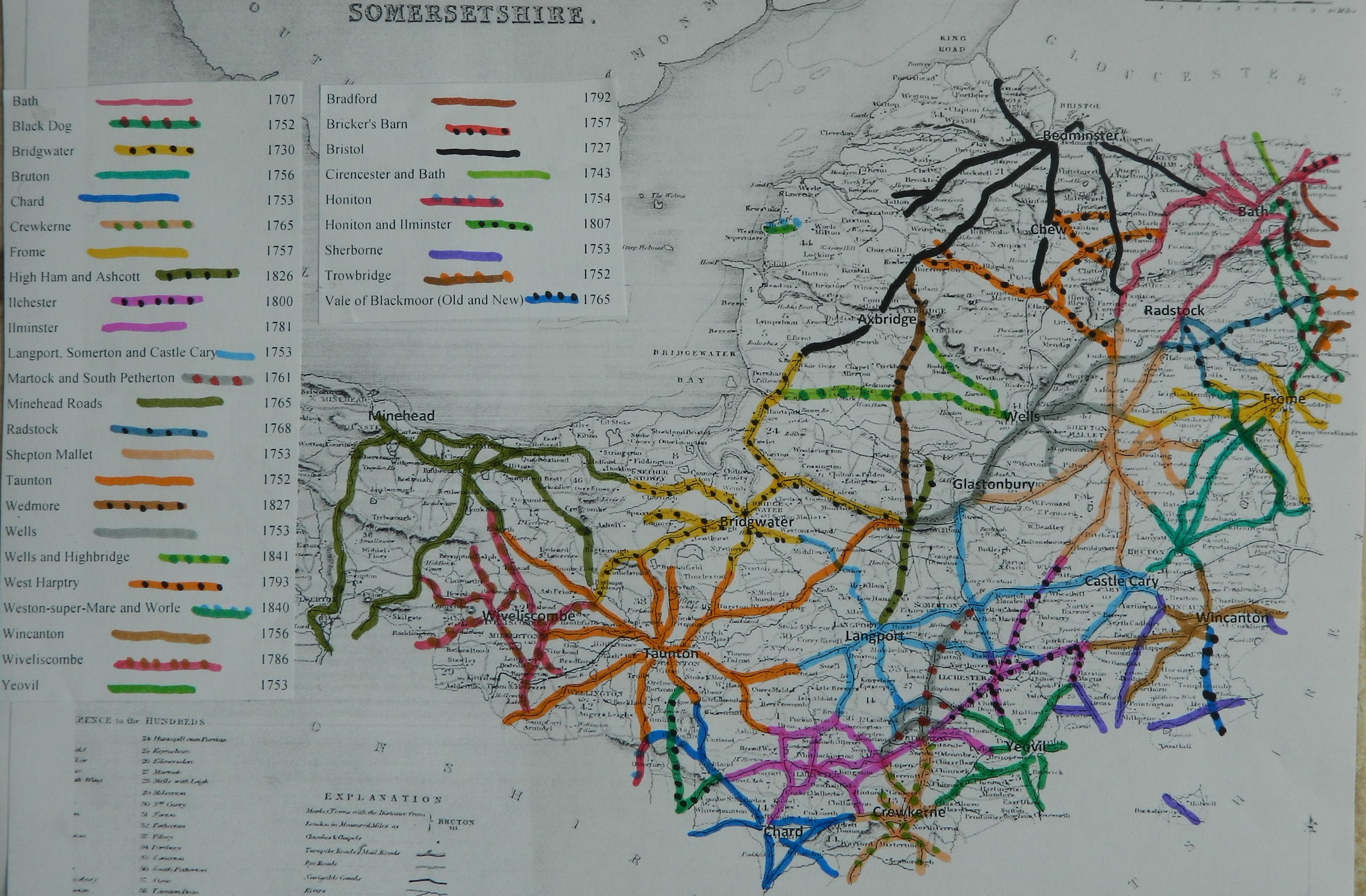
were roads radiating out of Radstock including roads to the coalmines on the
Mendips.
|
Radstock |
Buckland Dinham
to Tinsbury |
8 Geo3 c53 |
1768 |
|
|
|
|
29 Geo3 c101 |
1789 |
|
|
|
|
50 Geo3 c2 |
1810 |
|
|
|
|
11 Geo4 |
1830 |
1861 |
|
|
|
|
|
|
|
|
Expired |
|
|
1872 |
Radstock 1810
An
Act to enlarge the Term and Powers of Two Acts of His present Majesty, so far
as the same relate to the Road from Buckland Dinbam to Radford Bridge, and from
Midsomer Norton to Norton Saint Phillip, and from Kilmersdon to Radstock in the
County of Somerset. [21st March 1810.]
Thomas Miles of Stone
Easton (clerk to the trust) reported
There are 3 districts with
16 miles 3 furl, 3 miles 4 furl. and 3 miles 4 furl. of road in each; through
7, 2 and 2 parishes respectively– all repaired by the trustees
4 toll gates and 1 side
bar on the first district, 1 gate on the 2nd District and none on
the 3rd District
The roads are stated to be
in “good” repair – no part under indictment for want of repair.
In “Return of length of road in
each Turnpike Trust in
Trust reported 16 miles 6 furl. 11 yds (7 miles less than in 1840)
BPP (1854) No. 18.—RADSTOCK ROADS.
The existing Act for these roads (the 11th of George IV. cap, 34) was passed in the year 1830, and repealed the previous Acts of the 8th and 29th of George III. Its term of thirty-one years will not expire until the year 1861.
The special object of the Trustees in applying for a new Act is thus stated by the clerk :—" The application to Parliament for an Act, is to make a new Turnpike Road from our turnpike at Writhlington, to meet the Bath Road near Dunkerton, instead of going the circuitous route as at present through Radstock, which will be a saving of a mile and a quarter, and be an accommodation to the inhabitants at Kilmersdon, Mells, and neighbourhood; and for conveying of coal from the Three Pits at Writhlington, and one at Vobster towards supplying Bath and its vicinity."
The present roads belonging to the Trust are the under mentioned:—
Miles. Furl. Yds.
1. From the White Post to the junction of the three
Trusts at Philips Norton - - - 9 0 110
2. From Radstock to Buckland bridge - - - 5 1 198
3. From the Fir Tree Inn to the cross ways beyond
Nobsbury - - - - • 1 0 198
4. From Ammerdown Lodges to the Bruton Trust at
Babington Corner - - - - 1 2 165
Total length of road - - 16 6 11
On the first-named road there are two toll-gates about four miles and 115 yards apart, and one side-bar at Charlton; and on the road from Radstock to Buckland there are two toll-gates about three miles apart, but only one toll is payable at these gates for coal, and one toll and a halt for all other traffic. On the road from the Fir Tree Inn to the cross-ways beyond Nobsbury there is one toll-gate, which clears no other gate. Reduced tolls are at present collected upon some classes of traffic.
The roads as described in the existing Act were divided into three
districts; but certain portions were not
made, namely:—
Miles.
Furl. Yds.
Part of " the first district" described in Section 2, as
the road leading from the street at Radstock
to the road at the top of Gallows
Hill, in the parish of Kilmersdon,
in length - -16' 156
And the whole of " the third
district" as described
in Section 2 being, in length - - - 3 5 66
Total length of road abandoned • 5 4 2
The debt upon this Trust previously to the
passing of the present Act was £2,655, and the sum afterwards borrowed was
£1,300, making a total debt of £3,955, bearing
interest at four and a half per cent. The Trustees commenced paying off this debt in the year 1841, and reduced the amount by subsequent payments until the year 1852, when the last portion was paid off.
It appears therefore unnecessary to present the
usual abstract of the annual accounts from the
year 1834
It will be observed that the above account
shows a considerable annual excess of income over the
expenditure; namely,—jn .the year 1852 the income was £2,144.
17s. 7d-, the expenditure
(exclusive of debt and interest paid) £1610 4s.
9d., leaving a balance of £534. 12s. l0d.
And in 1853 the income was £533 17s 2d more than the expenditure. The
balance in hand on the 31st of December-last was £850. 13s, and would have been £1,294. 13s. 2d. if the funds of the Trust in the
hands of the late bunkers could have been recovered. It would therefore
appear that us far as the present Trust is
concerned, the annual surplus of upwards of £500. would enable the Trustees to
make further reductions in the rate of toll. In respect to the loss sustained
by the Trust by the bankruptcy of the late treasurer or bankers, the clerk has forwarded the following
statement:—" I do not know who were the sureties for the late
treasurer of the Trust. On the 2nd day of July, 1846, Mr. Thomas Miles of Stoneaston, or
In the present application to Parliament, it is proposed to repeal the existing Act and to take new powers in lieu thereof, for a term of twenty-one years. The principal clauses in the new Bill are the following:—
Clause 9 describes the roads now belonging to the Trust [omitting the portions of road named in the existing Act, about five and a half miles in length, which were abandoned.]
Clause 11 describes the new line of road
proposed to be added to the Trust. The new line will be
about two and a quarter miles in length, portions of which appear to be
existing highways. The inclinations of the road in both directions from the Writhlington Lower Coal Works, are proposed to be made as steep
as one in twelve, which inclination will extend towards the
Clauses 12 and 13 allow certain deviations to be made from the plan and section.
Clause 14 allows lands to 'be taken notwithstanding errors of description, by obtaining a certificate from two or more Justices in petty sessions.
Clause 19 limits the time for the compulsory purchase of land to three years, and Clause 20 allows four years for the completion of the works.
Clause 21 continues the present tolls until the 28th day of September, 1854. Clause 22 specifies the new tolls, which are generally less than the rates allowed by the existing Act, and in some respects less than the reduced tolls now collected. By the present Act, the toll payable upon coal is lower than upon any other description of traffic ; but it is proposed to put all the tolls on the same level, by which arrangement, coals will be charged the same as at present, but all other classes of traffic will be reduced. No Toll is proposed upon dogs drawing.
Clause 24 allows only one toll to be collected on the whole of the roads, instead of a separate toll on each district, and an additional half-toll (except for coals) on the first district, agreeably to the 9th section of the present Act.
Clause 27 allows one-horse carts to be weighed, as in section 14 of the existing Act; but the weight is now proposed to be extended from 1 ton 4 cwt., to 1 ton 10 cwt. in summer, and 1 ton 5 cwt. in winter.
Report of 1868/9 on Disturnpiking
Radstock Trust was continued on account of the heavy minerals traffic.
(roads identified and mapped in “Somerset Roads
– the Legacy of Turnpike, by Bentley and Murless 1985”)
A362 Pows Ash through Writhlington to Buckland
Bridge
B3139 White Post to Kilmersdon
A366, A362 jct to Norton St Philip & to
Tuckers Grave
Click
here for a map of Somerset Turnpike Roads
Click
here to return to Turnpikes
Home
Return to Turnpikes in Somerset general page
|
Road
Classification Number |
Route |
GATE NAME |
OS Grid Ref-
Prefi |
Easting |
Northing |
District |
Civil Parish |
Location (Name or
Number) |
Road or Street
(see across) |
Position |
Evidence |
Revised 23rd Sept
2013 |
|
A362 |
Radstock to Frome |
Radstock |
ST |
69 |
52 |
AVBS |
NORTON RADSTOCK |
Radstock |
|
|
; ; Turnpike
Trust Returns 1824; |
|
|
A362 |
Radstock to Frome |
Writhlington |
ST |
7 |
5 |
AVBS |
NORTON RADSTOCK |
Writhlington |
|
|
; ; Turnpike
Trust Returns 1824; |
|
|
|
Charlton (side
dar) |
ST |
SOME |
Charlton |
|
|
|
; ; Turnpike
Trust Returns 1824; |
||||
|
A366 |
Trowbridge
to Radstock |
Tucker's
Grave |
ST |
7515 |
5510 |
SOME |
HEMINGTON |
The Toll
House, Faulkland |
Tucker's
Grave Crossroads |
opp. pub |
OS 1st
Series; ; Turnpike Trust Returns 1824; |
|
|
B3139 |
Wells to
Trowbridge |
Kilmersdon |
ST |
69489 |
52424 |
SOME |
KILMERSDON |
The Toll
House, No. 35 |
Kilmersdon
Hill |
bottom of
hill, was moved in 1830 |
; ;
Turnpike Trust Returns 1824; |
|
In the Milestone
Society Database, 9 milestones are identified along this road, mostly on the A362,
A366 and B3139, most in a design referred to as London Plate casting. Based on the mileage
reported by the Trust in 1840, would expect 23.