This trust was created
in 1730, in the early part of the turnpike era.
Its main responsibilities were (a) a section of the
|
Bridgwater |
|
3 Geo2 c34 |
1730 |
|
|
|
|
32 Geo2 c40 |
1759 |
|
|
|
|
19 Geo3 c100 |
1781 |
|
|
|
|
41 Geo3 c12 |
1801 |
|
|
|
|
3 Geo4 c65 |
1822 |
1843 |
|
|
|
|
|
|
|
|
Expired |
|
|
1870 |
An Act to
continue for Twenty-one Years, and from thence to the End of the then next
Session of Parliament the Term, and alter and enlarge the Powers of Two Acts,
passed in the Thirty-second Year of the Reign of His late Majesty King George
the Second, and in the Nineteenth Year of the Reign of His present Majesty, for
repairing several Roads leading to the Town of Bridgewater in the County of
Somerset, and other Roads therein mentioned, so far as the said Acts relate to
the said Roads leading to the said Town. [2d April 1801.]
Bridgwater
1822
An Act to
repeal several Acts passed for repairing several Roads leading to the Town of
Bridge-water in the County of Somerset, and several other Roads therein
mentioned, so far as the said Acts relate to the Roads leading to the said
Town, and to consolidate and comprise the same in One Act of Parliament. [24th
May 1822.]
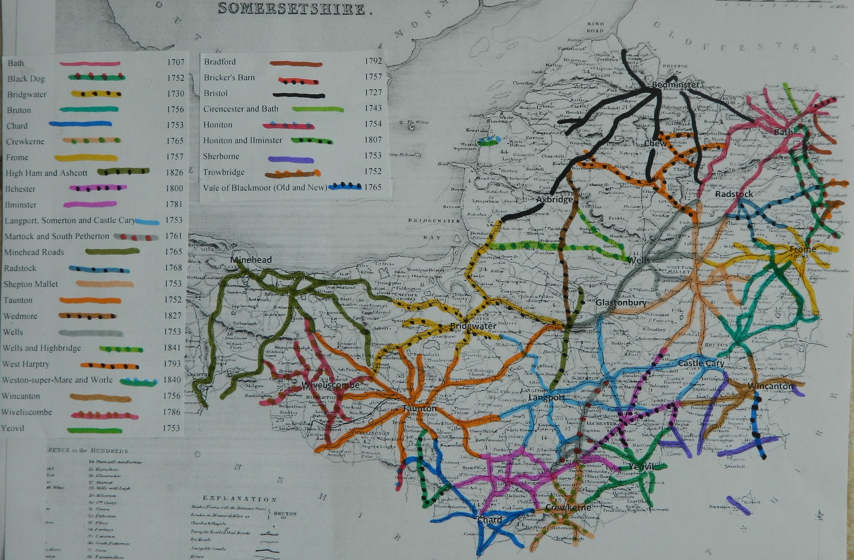
Thomas Symes of Bridgwater (clerk to the trust) reported
There are 49miles 3 furl. of road through 31 parishes – all repaired by
the trustees
10 toll gates and 5 side bars
The roads are stated to be in “good” repair (with a few exception)– no
part under indictment for want of repair.
In “Return of length of road in each Turnpike
Trust in
Trust reported 49
miles 3 furl. 160 yds (similar to that in 1840)
(road identified and mapped in “Somerset Roads
– the Legacy of Turnpike, by Bentley and Murless 1985”)
A38 from East Brent to Thurloxton
A39 from Nether Stowey to piper’s Inn
A372 Bridgwater to Langport Bridge
UC road from Bridgwater through Elmore
Click
here for a map
of Somerset Turnpike Roads
Click
here to return to Turnpikes
Home
Return to Turnpikes in Somerset general page
|
Road
Classification Number |
Route |
GATE NAME |
OS Grid Ref-
Prefi |
Easting |
Northing |
District |
Civil Parish |
Location (Name or
Number) |
Road or Street
(see across) |
Position |
Evidence |
erected by
(Turnpike Trust or Authority) |
Revised 23rd Sept
2013 |
|
A39 |
Bridgwater to
Minehead |
Ashcott (2) |
ST |
45 |
37 |
SOSG |
ASHCOTT |
|
|
|
; ; ; |
Bridgwater |
|
|
A39 |
Bridgwater
to Minehead |
Cossington |
ST |
35682 |
39694 |
SOSG |
CHILTON
POLDEN |
Moon
Cottage |
Bath Road,
Cossington turn |
behind
stone walls at jct leading to Cossington village |
; ; ; |
Bridgwater |
|
|
A38 |
Bridgwater
to Taunton |
East |
ST |
30438 |
37345 |
SOSG |
BRIDGWATER |
Toll House,
No. 43 |
Monmouth
Street |
just S of
traffic island at jct with A39 |
OS 1st
Series; ; toll advert 1822; |
Bridgwater |
|
|
UC road |
|
Enmore |
ST |
290 |
366 |
SOSG |
BRIDGWATER |
Durleigh Road |
|
|
OS 1st Series; ;
advert for lease of tolls 1822.; |
Bridgwater |
|
|
Sandford |
ST |
2696 |
3821 |
SOSG |
CANNINGTON |
junction of five
roads, Sandford Waters |
|
|
; ; ; |
Bridgwater |
|||
|
A38 |
Bridgwater
to Taunton |
South |
ST |
30163 |
36305 |
SOSG |
BRIDGWATER |
Old Toll
House, No. 103 |
Taunton
Road |
by Paragon
Laundry, by jct with Southgate Avenue |
OS 1st
Series; ; toll advert 1822; |
Bridgwater |
|
|
B3339 |
Bridgwater
to Williton |
Wembdon |
ST |
2764 |
3787 |
SOSG |
WEMBDON |
Old
Tollgate House |
opth |
at jct with
Skimington Lane at western end of village |
; ; toll
advert 1822; |
Bridgwater |
|
|
UC road
(was B3339) |
Bridgewater
to Minehead |
Wembdon
Road |
ST |
28713 |
37151 |
SOSG |
BRIDGWATER |
No. 121 |
Wembdon
Road (cut off section) |
by old
borough boundary at end of cul de sac |
OS 1st
Series; ; ; |
Bridgwater |
|
|
A372 |
Bridgwater to
Othery |
Westonzoyland |
ST |
31 |
35 |
SOSG |
WESTONZOYLAND |
|
|
|
; ; advert for
lease of tolls 1826 & 22.; |
Bridgwater |
In the Milestone
Society Database, 16 milestones are identified along this road, mostly on the
A38 and A39, several in designs referred to as Bridgwater Plates. Based on the mileage
reported by the Trust in 1840, would expect 49.