CONTENTS
8.1 The First Roads through Oxford........................................................................................... 2
8.2 Medieval and Tudor Highways and
Bridges.......................................................................... 3
8.2.1 Roads East of Oxford.................................................................................................... 3
8.2.2 Roads West of Oxford................................................................................................... 4
8.2.3 Roads South of Oxford.................................................................................................. 5
8.2.4 Roads North of Oxford.................................................................................................. 5
8.3 Seventeenth and Eighteenth
Century Roads.......................................................................... 5
8.4 Road and Bridge Maintenance
around Oxford...................................................................... 6
8.4.1 Hermits & Statute Labour............................................................................................... 6
8.4.2 Oxford Mileways & other
Highways.............................................................................. 7
8.5 The Turnpikes....................................................................................................................... 7
8.6 The Stokenchurch, Wheatley,
Begbroke & New Woodstock Turnpike................................. 8
8.6.1 Relevance of the Road................................................................................................... 8
8.6.2 Officers of the Trust...................................................................................................... 9
8.6.3 Acts for Renewal and New
Roadworks........................................................................ 10
8.6.3.1 Acts of 1740, 1762 and 1778................................................................................ 10
8.6 3.2 The New Road through
Headington....................................................................... 11
8.6.4 McAdam’s Improvements............................................................................................ 12
8.6 4.1 Major Projects at
Stokenchurch, Tetsworth, Wheatley & Bayswater...................... 12
8.6 4.2 Other Engineering work......................................................................................... 13
8.6.5 Toll Gates..................................................................................................................... 14
8.6.5.1 The Main Gates..................................................................................................... 14
8.6.5.2 Other Gates............................................................................................................ 15
8.6.6 Toll Income.................................................................................................................. 15
8.6.6.1 Tolls & Traffic...................................................................................................... 15
8.6.6.2 Toll Collection....................................................................................................... 16
8.6.6.3 The Lessees of Tolls.............................................................................................. 17
8.6.7 Expenditure.................................................................................................................. 17
8.7 St Clement's Turnpike Gate
& the Henley Road................................................................. 18
8.7.1 The Road along the Thames
Valley.............................................................................. 18
8.7.2 Oxford Improvement Act............................................................................................. 18
8.7.3 The St Clement’s Trust................................................................................................. 19
8.7.3.1 Improvements at Magdalen
Bridge........................................................................ 19
8.7.3.2 Financial Irregularities........................................................................................... 20
8.8 Turnpike Roads to the West................................................................................................ 20
8.8.1 The Cotswold Road...................................................................................................... 20
8.8.2 Crickley Hill &
Campsfield Turnpike.......................................................................... 21
8.8.2.1 The Initial Act over Two
Counties......................................................................... 21
8.8.2.2 Operating the Trust................................................................................................ 22
8.8.3 Botley, Fyfleld &
Newlands Turnpike......................................................................... 23
8.8.3.1 Swinford Bridge.................................................................................................... 23
8.8.3.2 Roads from Botley to Witney................................................................................ 24
8.8.3.3 Botley to Fyfield Road.......................................................................................... 25
8.9 Turnpikes South from Oxford............................................................................................ 25
8.10 Turnpikes North from Oxford.......................................................................................... 26
8.10.1 Woodstock & Rollright
Lane Turnpike...................................................................... 26
8.10.2 Charlbury Roads........................................................................................................ 27
8.10.3 Kidlington & Deddington
Turnpike............................................................................ 27
8.10.4 Turnpikes through Gosford
and Weston on the Green............................................... 28
8.11 Decline of the Turnpikes and
Modern Developments....................................................... 28
8.11.1 Financial Problems for the
Stokenchurch & Woodstock Turnpike............................. 28
8.11.2 Surviving Evidence of
Turnpikes............................................................................... 29
Sources..................................................................................................................................... 30
RUTV
8 is booklet number 8 in a series on the turnpike roads of Oxfordshire and
adjoining areas.
Turnpike Roads Around Oxford
8.1 The First Roads through Oxford
The Thames is a formidable barrier for travellers between the Midlands and southern England. The great curves of the river valley formed the border between Celtic territories, later became a frontier separating the Saxon kingdoms of Mercia and Wessex. For many centuries it was to be the boundary between the old counties of Berkshire and Oxfordshire. A bold traveller could cross the river at several places on the wide flood plain where Oxford now stands. Prior to improvement of the river navigation by the Thames Commissioners, the many streams and islets at the confluence of the Thames and Cherwell created a wide expanse of slow flowing water in relatively shallow channels which could be crossed by a series of fords. Early travellers along the Corallian ridgeway no doubt took advantage of these (Figure 8.la). Medieval records refer to a regia via that followed the line of the ridge from Brill, through Forest Hill (named from the old English for hill ridge) to Oxford (VHCO 4; 123). Although Roman trade roads probably crossed the river here, there was no urban settlement close to the fords. Roman potteries flourished away from the river around Cowley and Headington to the east and around Boars Hill to the west. A major Roman road from the regional centre at Dorchester to Alchester was built along the high ground to the east on the Cherwell. Akeman Street, the principal east/west road in the region, ran well to the north, along the edge of the Cotswolds and through Alchester/Bicester, crossing tributaries to the Thames where they were still minor streams. There is strong evidence for a secondary road running south-west from the Hinksey ford towards Frilford. Margery (1973) has speculated that the routes which were to form the main east/west and north/south roads through Oxford are also Roman in origin. Although Roman traders may have travelled this way, it is unlikely that these tracks would have carried sufficient traffic to justify the attention of Roman road engineers.
About 727A.D. the Saxons
created the permanent settlement beside the main ford of the Thames (Hassell
1987) and in 912 the Anglo-Saxon Chronicle refers to Oxnaforda (Davis 1973). An
artificial embankment leading to the ford, thought to have been built in the
8th century, and a stone ford, dating from the 9th century, have been found on
the north bank of the river below St
Aldate's. This seems to be the main Langford crossing over a number of
streams and islets that were formed where the river cut through earlier gravel
deposits (Figure 8.2). Once established, the new Saxon town and monastic
foundations on the north bank of the Thames eclipsed the Roman town of Dorchester
to become the chief trading and ecclesiastical centre of the south
Midlands. The Thames was a disputed
frontier between Mercia and Wessex and so Oxford had strategic importance
controlling travel between the northern and southern banks of the river. Alfred's son, Edward the Elder was probably
responsible for laying out the basic street plan of the defended burgh at the
southern end of the dry gravel ridge between the Thames and the Cherwell
(Hassell 1987). Traffic from the
Cotswolds was funnelled through Oxford to several fords over both rivers. There were three principal places where the
Thames could be crossed. The most
northerly of these was at Godstow. A second, further downstream at Osney, had
branches to Seacourt and towards North Hinksey.
The southerly crossing was at an inflection of the river close to the
confluence with the Cherwell (Figure 8.2). Here the main stream is approached
directly across the river gravels rather than across the alluvial flood
plain. This southern ford was conveniently
situated on a direct route between the Mercian centre at Northampton and the
Channel port of Southampton in Wessex.
This highway, mentioned in the Anglo-Saxon Chronicle, may have crossed
the Cherwell at Gosford, entered the north gate of Oxford and passed through
the south gate over the Thames to the Berkshire bank (Figure 8.1b). From
Hinksey the highway ran south, probably along the old Roman road via Foxcombe
Hill and Wootton to cross the Ock at Abingdon.
Timbers and stones would have
been used to stabilise the river bed at the main ford. The Saxon's may have built a simple bridge
beside the ford but the low lying ground and minor streams to the south would
still have presented travellers with problems until a full causeway was
built. Although St Frideswide's Abbey
was close by, Abingdon Abbey, which owned land on the Berkshire side, had
particular interests in maintaining the bridge that eventually replaced the
ford.
8.2 Medieval and Tudor Highways and Bridges
Oxford grew and prospered through trade and manufacture, benefiting from its good access to primary agricultural products. The corn and wool from the county were a source of wealth that made Oxford the eighth largest provincial town in England by 1334 (Cooper 1979). The royal castle at Oxford, estate at Woodstock and hunting forest at Stowood gave added status to the area. Such an important regional centre needed good communications to the capital of the new Kingdom of England and so roads to the east grew in importance at the expense of the older routes from the Midlands to the south coast. There are two primary land routes between Oxford and London, one over the Chilterns through Wycombe and Uxbridge, the second along the Thames valley. These complemented the river route along the meandering Thames. Although the river journey may have been longer, it was probably the preferred route for heavy loads until the late 16th century (Peberdy 1996).
Any road east from Oxford must
cross the Cherwell and then the Thame and may also have to cross the Thames as
it meanders towards London. The gravels
immediately east of Oxford made this an obvious place to crossing of the
Cherwell (Figure 8.2). There are three medieval bridges over the Thame to the
south-east of Oxford; at Wheatley, Chislehampton and Dorchester (Figure 8.1c),
all of which must have been on important roads towards the lower Thames. The oldest stone bridge across the middle
Thames is at Wallingford, beside the site of the royal castle. The bridges at Henley and Maidenhead were
built later, allowing travellers to avoid the long journey along the deep
curves of the main Thames valley.
8.2.1 Roads East of Oxford
It is clear from an analysis of
the itineraries of the Plantagenet kings that in the 12th to the 14th centuries
the principal road approaching Oxford from the east was the route from
Wallingford (see RUTV 9). The royal
travellers from Windsor or Westminster passed through Reading, crossed to the
northern bank of the Thames by Wallingford Bridge and then bridged the Thame at
Dorchester. By the late medieval period
the new bridges at Henley and Maidenhead brought Oxford-bound traffic further
north (Figure 8.1c) but the traveller still had to cross the lower reaches of
the Thame. The bridges at either
Chislehampton or Dorchester were convenient for those wishing to reach Oxford
and John Leland in the 1530s used both during his travels in the Thames valley
(Toulmin Smith 1964). Pontage was
granted for Chislehampton Bridge in 1444.
Leland said he "passid over 3
litle bridges of wood, wher under wer plaschsy piites of water of the
overflowing of Tame ryver, and then straite I rode over a great bridge under
the which the hole steame of Tame rennith.
Ther were a 5 great pillers of stone, apon the which was layid a timbre
bridge" (Toulmin Smith 1964).
The stonework of the existing bridge is probably late 16th century (VHCO
5, 5). In contrast, Dorchester
Bridge is first mentioned in 1146 and is described by Leland as "of a good lenghth: and a great stone causey
is made cum welle onto it. There be 5
principals arches in the bridge, and in the causey joining to the south ende of
it". A survey of 1348 mentions
a "way" to Oxford from
Dorchester (VHCO 5, 40). Since
Dorchester Bridge served traffic using the older route to London through
Wallingford, as well as the later route through Henley, this was always the
principal road. Even so, the
Chislehampton road was of some importance, despite the climb over a steep
section of the Chilterns.
The Chislehampton and
Dorchester routes used to merge well to the east of Oxford. The former came along Garsington Way and
crossed Cowley Marsh. The latter passed
through Littlemore and Temple Cowley to join the other road at St Bartholomew's
Hospital. A single road, sometimes
referred to as Londonyshe Street (Hibbert 1992) then ran along a causeway to St
Clement's where it met the Wycombe road.
All these routes approaching Oxford from the east crossed the Cherwell
by the Pettypont, later called Magdalen Bridge.
The original wooden bridge was mentioned in 1004. By the 16th century, this had been replaced
by a stone bridge that was described as being 500 feet long, having 20 arches
and deep cutwaters (VHCO 4, 284).
Although this river crossing is important in the development of Oxford,
its function is secondary to the more important crossing of the Thames along
the Grandpont.
The more northerly route from
Oxford to London across the Chilterns is much more hilly and did not achieve
prominence until the medieval period when better vehicles were available. The Gough map of 1360 shows this as the
highway from London to Gloucester and South Wales. The road does not have to bridge the Thames,
although it climbs steeply up to Shotover Plain to reach the ridgeway. Further
east it has an extremely steep climb up the scarp face of the Chilterns at
Stokenchurch and also traverses the deep valley of the Wye. It crosses the Thame at Herford (the herepath
ford, VHCO 5, 117) near Wheatley where there was an ancient bridge. The bridge was repaired with local stone in
1284 and was important not only for Oxford traffic but also for travellers to
the Cotswolds and Worcester. The Gough
map marks Tetsworth on the road to Wycombe, perhaps indicating that even before
the hermitage was established, it was an important stop on the road.
8.2.2 Roads West of Oxford
Robert d'Oilly was Warden of
the newly built Norman castle at Oxford until his death in 1092. He is credited with building the large bridge
and causeway leading from the south gate of the town; Wood thought the bridge
dated from 1085. It may be that d'Oilly
only improved an existing causeway but this Grandpont extended for a mile and
eventually had 42 arches (Davis 1973).
The fourth arch was converted into a drawbridge during the 15th century
but was later removed. However, the
gatehouse became a famous landmark (Figure 8.3), referred to as Fryer Bacon's
Study since it was said that Roger Bacon had studied the night sky from rooms
above the gate. In medieval times this
was the principal route from the Oxford for heavy traffic and armies heading
towards both the south and the west.
After crossing the main stream outside the south gate, the causeway ran
southwards to the end of the gravel terrace (Figure 8.2). It then turned west,
at what is now called Redbridge, to cross two streams at Mayweed ford and
Stanford (stoneford) before reaching the edge of the flood plain below Hinksey
Hill. Although the Grandpont was on the
old north/south route through Oxford, it also served travellers heading
westwards. An old Roman road ran from
Hinksey, across Foxcombe from where it was easy to reach the Corallian ridgeway
to Faringdon and the Thames crossing near Lechlade. This involved two river crossings, but it
avoided the long northern sweep of the Thames and the marshy ground in the
Evenlode valley. The road from Oxford
through Faringdon to Bristol on the Gough map must have gone over the
Grandpont. Leland used this route "From Oxford thorough the Southgate and
bridge of sundrie arches over Isis, and along causey in ulter. ripa in Barkshir
by a good quarter of a mile or more, and so up to Hinxey hille about a mile
from Oxford. From this place the hilly
grounde was mearely wooddy for the space of a mile: and thens 10 miles al by
chaumpain, and sum come, but most pasture, to Farington, standing in a stony
ground in the decline of an hille." (Toulmin Smith 1964).
The existence of the Grandpont
reduced the need for another crossing of the Thames in the vicinity of
Oxford. Although the important
ecclesiastical institutions of Osney Abbey and Godstow Nunnery were sited close
to alternative crossings, none rivalled the south gate route. The earliest roads west from Oxford took
circuitous paths over the broad and boggy alluvial ground to the north and
south of the present Botley Road (Figure 8.2). The road serving Osney Abbey
used the Wereford or later Osney Bridge to cross the main stream. A subsidiary path then ran northwards across
the flood plain through Binsey to Seacourt on the far bank. The more important southern branch followed
an old stone causeway to a ford or ferry at North Hinksey (VHCO 4,
284). Leland travelled this road "from Oxford to Hinkesey fery a quartar of a
myle or more. Ther is a cawsey of stone
fro Oseney to the ferie, and in this cawsey be dyvers bridges of plankes. For there the streme of Isis breketh into
many armelets. The fery selfe is over
the principals arine or streame of Isis.
Beselles Legh a litle village is a 3 mile from Hinkesey fery in the
highe way from Oxford to Ferendune, alias Farington" (Toulmin Smith
1964). During the 16th century,
construction of Botley causeway and the Bulstake Bridge created a more direct,
safe route over the branches of the Thames and its flood-plain. Improvement of this series of causeways and
bridges was attributed partly to the charity of John Claymond. Another factor was the business interest of
Lord Williams who had acquired the Manor of Wytham after the dissolution of
Abingdon Abbey (Graham 1976). The new
highway carried traffic over to Cumnor Hill and from there along the Corallian
ridge to Faringdon. Nevertheless, to
reach Witney and the northern route across the Cotswolds to Cheltenham and
Gloucester, the traveller still had to use the ferry at either Eynsham or Bablock
Hythe. As a result, this route was
designated a horse road, unsuitable as a through-road for carriages.
The bridges over the two arms
of the river at Godstow are an enigma.
This crossing is the only one to the west of Oxford on Saxton's map of
1574. One of the existing bridges has a
pointed Gothic arch, evidence of a medieval origin. The bridges were probably in the care of
Godstow Nunnery, providing the ladies with a path over the Thames to the royal
residence at Woodstock. When the nunnery
was dissolved the property passed to the Duke of Marlborough and the bridge
seems to have lost any importance as a crossing for Oxford traffic. Presumably the Godstow crossing was too far
north to offer advantages over the Hanborough route to Witney or as route into
north Berkshire. In the 19th century the
City took a toll from users of these bridges to defray the cost of improving
the approaches on the Oxford side.
8.2.3 Roads South of Oxford
By the 13th century, bridges
over the Thames at Radcot and Newbridge provided a more convenient way south
from the Cotswolds for continental wool merchants bound for the Channel ports
(Figure 8.1b). To the south of Oxford the town of Abingdon had grown to
prominence with its large Abbey and its new bridge across the Thames was
carrying the east/west trade along the Gloucester Road. Hence, the trunk road south from Oxford lost
much of its earlier importance for trade although it remained a highway from
Oxford to important royal and ecclesiastical institutions around Salisbury and
Winchester.
8.2.4 Roads North of Oxford
Medieval roads running north
from Oxford declined in importance as the axis of trade became more
London-centred. Some traffic from the
Cotswolds and Gloucester may have turned south along the gravels to pass
through Oxford, but the steep climb on the London road to Shotover was a
disincentive to those who might descend from the high ridges. Wains carrying
cloth from Gloucestershire to London would have approached from Hanborough
where a medieval bridge across the Evenlode is mentioned in 1141. However, they would then have found it easier
to continue east over Campsfield to cross the Cherwell at Enslow and reach the
London road at Wheatley (Figure 8.1c). Other traffic from Worcestershire would
naturally keep to the high ground towards Islip and similarly head for Wheatley
Bridge.
Woodstock, the royal hunting
lodge north of Oxford, was probably a more important focus for medieval roads
than was the town on the river.
Proximity to the remains of Akeman Street meant that travel east/west
from Woodstock was relatively easy.
Traffic between Oxford and Woodstock would have used the road on the
ridge between the Thames and Cherwell, but would eventually have to cross one
or both of these streams. The King is
known to have passed through the east gate of Oxford and made his way through
the town to leave along the Woodstock road in 1339 (VHCO 4, 284). Oxford was a regional market for the
agricultural goods and so some traffic would have used the ridgeways beside the
Cherwell. Gosford is probably the most
important crossing for traffic coming south to Oxford and had a bridge in 1250
(VHCO 10, 159). Leland travelled
south from Banbury and Bicester (Bughchestar) through Islip to cross the
Cherwell by the Pettypont, presumably down the Marston road. He also mentioned Cherwell bridges at
Gosford, Emmeley and Heywood (Enslow and Heyford).
8.3 Seventeenth and Eighteenth Century Roads
From the 15th century onwards
Oxford declined in importance relative to other provincial towns but became
established as an academic centre. It
may be this latter factor, rather than its importance in trade, which led John
Ogilby to use Oxford as one of the important nodes for his road maps, published
in 1675. The majority of the routes
illustrated by Ogilby are still in use today, although there are interesting
differences in emphasis (Figure 8.4). The important radial route from London,
via Worcester, to Aberystwyth did not go through Oxford but kept to the high
ground, passing through Islip and Woodstock with only a branch road to
Oxford. Nor did the main trunk route
from London through Henley to Gloucester and St David’s go through Oxford but
favoured the Thames crossing at Abingdon.
The Oxford to Chichester road crossed Folly Bridge, as it had become
known, and Grandpont before following the old Roman road to reach Abingdon and
the south. This probably corresponds to
the Saxon trade route from Mercia to Wessex.
A short section of the old Northampton highway was followed by Ogilby's
road from Oxford, north to Bicester on the road to Cambridge; the Oxford to
Coventry road branched off near Weston on the Green. The Oxford to Salisbury road followed the
more modem road to Abingdon but the section from Milton Hill over the Downs is
now only a green road. Improvements to
Botley Causeway are apparent by the selection of this route for the Oxford to
Bristol road.
Ogilby's survey was copied by
other cartographers for almost two centuries and so any changes in the relative
importance of roads in the eighteenth century is difficult to judge. Examples of the road from London through
Worcester to Aberystwyth in Figure 8.5 are typical of the 18th century maps
using Ogilby's survey; the Senex map is identical with the Ogilby
original. Morden's map of 1695 drew
heavily on Ogilby's map but took into account comments from local experts. This map omits the Salisbury road but
includes the section of road from Benson to Oxford. The Henley to Oxford road seems to have
gained importance in Tudor times. This
was partly because it was an alternative route to London but also because
Henley was the head of navigation of the Thames for the large barges that could
not easily navigate the shallows, mill-dams and flash locks on the upper
reaches (Peberdy 1996). The journey
between London and Oxford can be shortened considerably by avoiding the long
meanderings of the river between Oxford and Reading. For instance the cloth used for a tapestry in
Magdalen College was shipped up river to Henley and then by cart to Oxford
(Anon 1968). King John had his plate
carted from Oxford to Henley for trans-shipment and Henry III had 30 tuns of
wine sent by river to Henley but carried from there to Woodstock by road
(Peberdy 1996) Improvements in the navigation as far as Culham in the mid-16th
century allowed larger barges to carry bulky goods closer to Oxford but the
round trip of 20 days by barge between Oxford & London took almost twice as
long as the river journey from Reading (Peberdy 1996). Hence, travel by road was often the most
practical means of transport for passengers and general goods. Bowen's map of 1755 (Figure 8.5) shows Oxford
at the hub of a road network serving both local and national needs.
8.4 Road and Bridge Maintenance around Oxford
8.4.1 Hermits & Statute Labour
During the medieval period most
travel was on horseback and overland goods were carried by packhorse. Any damage to the roadway was soon rectified
by natural processes and so highway maintenance was generally confined to the
care of bridges. The construction of new
bridges and the repair of existing crossings were frequently funded by
charitable bequests or occasionally by grant of a right to pontage. This allowed the holder to levy a toll on
those passing over and sometimes under, a bridge for a limited number of
years. The church itself had an interest
in maintaining the crossings close to its large houses and also acted as a
focus for charitable donations and gifts towards the repair of roads and
bridges. Hermits were often installed to
care for important bridges and to collects alms from travellers. Oxford's Pettypont was in the care of a
hermit in 1358 and at the Grandpont, in 1364, a hermit was installed at a
chapel to St Nicholas beside the bridge (VHCO 4, 248). On the road north of Oxford a hermit was
looking after the bridge over the Kingsbridge Brook at Freis as early as the
12th century (VHCO 10, 159).
Particularly important stretches of road were also looked after by
hermits. In 1447 a chapel to St John was
erected at Tetsworth with a resident hermit who was to use the labour of his
own hands to maintain the highway between Wheatley and Stokenchurch (VHCO 5,
147).
As trade grew and wheeled
vehicles were used instead of packhorses, roads through the town began to
suffer considerable damage. The area
outside the east gate was typical. The
weight of traffic carrying wood from Shotover, stone from Headington and
travellers from London had made it difficult to maintain a good roadway across
the wet ground at St Clement's. Three
grants of pavage were made by order of Richard II to encourage charitable
bequest for repairs to the road from Cherwell Bridge to Headington Hill (VHCO 7,
259). Wolsey had improved the road down
Headington Hill to facilitate the transport of building materials for Cardinal
College. However, the long-term
maintenance of the main highways and bridges was dependent on the charitable
funds generally organised through the various ecclesiastical institutions in
the area. These arrangements came to an abrupt end during the Reformation as
the chantries and monasteries and closed.
After a period of uncertainty
the means of maintaining roads was clarified by a series of Parliamentary Acts
during Elizabeth's reign. Each parish was given responsibility for maintaining
their own roads through what became known as statute labour. Each parishioner had to perform six days work
each year on repairing the parish roads. Those with property had to provide
teams (i.e. oxen or horses) to haul road-making materials. The parish had to
elect a local man to act as Surveyor to coordinate this labour. This system
worked well in rural parishes where the main need was to maintain lanes leading
to the fields or local mill. However, around urban areas where there was less
manual labour and teams and highways carried traffic into a market centre, the
Statute Labour was less capable of maintaining adequate roads.
8.4.2 Oxford Mileways & other Highways
Much of the damage done to the
roads of Oxford was caused by people from other parishes who came into
town. This iniquity was in part
remedied, in 1567, through the Oxford Mileways Act. This obliged those living
within five mile of the town to contribute labour for maintaining the roads and
bridges within one mile of Oxford. The
system was administered in four divisions and stones still mark the limits of
the Mileways at St Giles' to the north and Iffley Turn, Cheney Lane and
Headington Hill to the east. A map from
the 18th century shows that Botley Causeway was maintained under the
Mileways Act and in this case parishes across the Thames in Berkshire, such as
Eaton and North Hinksey, were included in the obligation to provide labour. The
principles on which the Oxford Mileways worked were similar to those that
guided the creation of turnpike trusts 150 years later, but in the 16th
century granting powers such as this to a town was very unusual and it is
intriguing as to why Oxford won such a privilege.
The remaining Mileway stones
date from the 17th century by which time the Mileways Act was less effective
and was resented since it placed no obligation on the residents of Oxford
itself. Nevertheless, the importance of
the St Clement's road into Oxford meant that the city did contribute to some
repairs. In 1592 the city reluctantly
paid for repairs at St Clement's prior to a royal visit but when more work was
necessary in 1614, they announced that this was done of "mere
goodwill" (Hibbert 1992). Much
still rested upon the parishioners. For
instance, the road from St Clement's church to the foot of Headington Hill was
pitched with stones in 1682. Flags of
Headington hardstone where used to pave the great holloway up the hill in 1725
but the road was so rough that members of the University created the raised
footpath that still survives today (VHCO 7, 259).
Although the problems within
Oxford were ameliorated, there was no general remedy on the main roads through
parishes outside the city. These
suffered the same fundamental problem of damage caused by through traffic. The old "London Way" from Stanton
St John to Wheatley Bridge past Stowood seems to have been maintained by
charity donations from users since in the 16th century there was in Forest Hill
parish "an honest poor olde man who
lived by opening the gate and asking a penny for God's sake" (VHCO 7,
123). An old milestone has been found
near Stowood, engraved "Here begins
Stowood High Way which ye County is to repair, 1680" (Lawrence 1977).
8.5 The Turnpikes
From the beginning of the 18th
century, turnpiking became a very effective means of ensuring that those who
used the road contributed directly to its upkeep and that the statute labour of
individual parishes was coordinated.
Trustees were appointed to improve a length of main road that passed
through several parishes. They were
empowered to erect turnpike gates, to levy tolls on travellers and use the
money raised to improve and maintain the road as a whole. An Act of Parliament was necessary to create
these trusts that had a finite life. The
main roads radiating from London and carrying the heaviest traffic were the
first to be turnpiked. The highway
approaching Oxford from the east, over the Chilterns, was turnpiked from
Stokenchurch to Woodstock and Oxford in 1719 and then on from Woodstock to
Rollright in 1729 (Figure 8.7). The second route from London to Oxford, the
Henley Road, was taken under the care of a turnpike trust in 1736. This road was equally important as the main
Gloucester Road through Abingdon linking with the Fyfield to St John's Bridge
road that had been turnpiked in 1733.
The other main roads out of
Oxford were not turnpiked until the second wave of Parliamentary activity after
1750. This suggests that Oxford was not
then on a major route to places elsewhere in the Kingdom. The first turnpike road from Oxford to Witney
was approved in 1751 under the direction of the Crickley Hill & Campsfield
Trust. In order to avoid the Thames
flood plain, travellers had to go northwards from Oxford as far as Campsfield,
now Oxford airport, before turning west to bridge the Evenlode at Long
Hanborough. In 1755 the road from Fryer
Bacon's Study, outside the south gate, to Hinksey with the branches to Abingdon
and Faringdon were turnpiked. The road
to the north through Kidlington and Adderbury to Banbury was improved by an Act
of 1754 and that through Middleton Stoney to Towcester in 1756.
A third wave of turnpike
activity was associated with improvement of the river crossings. In 1767 the building of Swinford Bridge
caused major changes in the pattern of travel to the west of Oxford. Traffic used the new road over Botley
Causeway and the Swinford Bridge to reach Witney and the Cotswold Road more
directly. From the causeway, Oxford
traffic could also use the road westwards to Faringdon along the ridgeway. This made the old road over Foxcombe
redundant and meant that only traffic for Abingdon and the south continued to
use the Grandpont. The better road from
Botley also encouraged turnpiking of the Besselsleigh to Wantage road in
1771. The Oxford Improvement Act of 1771
allowed for the rebuilding of Magdalen Bridge and improvement of the roads
through St Clement's.
Finally minor improvements in
the network were dealt with either by amendments to existing trusts, such as
the new road through Headington in 1788, or by Acts covering short lengths of
new road such as from Kidlington to Weston, through Gosford which was turnpiked
in 1781.
The various turnpikes will be
dealt with in the same order as above; from the east, then west, south and
finally north (Figure 8.7). Several roads to the south of Oxford have been
dealt with in detail elsewhere; Besselsleigh in RUTV 4, the Abingdon and Henley
Roads in RUTV 7. Records from the Stokenchurch Trust have survived in the
Oxfordshire Record Office and so this turnpike will be dealt with in most
detail below. Some records from the last years of the St Clements Trust have
been lodged in the Bodleian Library.
8.6 The Stokenchurch, Wheatley, Begbroke & New Woodstock Turnpike
8.6.1 Relevance of the Road
For Ogilby, the road to
Worcester was the most important radial from London to the south Midlands. However, by the early 18th century,
Birmingham grew in prominence as the industrial revolution gathered momentum. Three routes to Birmingham were turnpiked in
the early 18th century. The most
important was through St Albans, Stony Stratford & Coventry, another
through Uxbridge, Wendover, Banbury & Warwick and the third from Uxbridge
through Stratford-upon-Avon passed closest to Oxford. The Uxbridge road was turnpiked in 1715 and
in consecutive Acts in 1719, trusts were established to cover the road from
Beaconsfield to Stokenchurch and from Stokenchurch down the steep face of the
Chilterns to Enslow Bridge and Woodstock, north of Oxford. As far as Oxfordshire this route was the old
Worcester Road but a branch near Chipping Norton carried traffic northwards
towards Birmingham. The branches from
Stratford to Birmingham and Stonebow Bridge to Worcester were turnpiked in 1726
and most other sections of the routes from London to Worcester and Birmingham
were in the care of turnpike trusts by 1731. The exceptions were roads high
upon the Cotswolds from Rollright to Long Compton and Bourton to Broadway. These were on well drained, limestone and so
did not suffer the same degree of damage from wheels as the roads in the wet
river valleys.
A Parliamentary Committee was
told that between Beaconsfield and Stokenchurch the road was frequented by
wagons and other heavy carriages and had become so very ruinous and out of
repair that in the winter season it was dangerous to travellers (JHC 19,
29). Evidence in support of the
Stokenchurch road was given to a Parliamentary Committee in 1717 by a group of
gentlemen from the area; Richard Carter, Thomas Cousins, William Lipscombe,
Richard Brown, Richard Hitchcott, Adam Bellinger (a wealthy wagoner from
Woodstock) and George Ryves (JHC 18, 707). The main points were reiterated in 1718 by Mr
Carter, Mr Beeson and Mr Weate (JHC 19, 20). They testified that "inhabitants of the several parishes have not
only constantly done more than their statute work, but also raised large sums
of money and duly applied the same towards repairing the roads and that proper
materials for amending the highways lie at a great distance from some parts of
the said road and that the petitioners have often been obliged to pay twelve
pence per load, at least, for stones".
This last statement is at odds with the evidence given by Mr McAdam a
century later but may indicate that inappropriate materials being used. For instance Plot in 1677 noted that the road
near Tetsworth was mended with local stone called maume, which unfortunately
broke up in the winter and "would
have been better for mending their land than the highway". The petitioners still viewed the road network
around Oxford in the same manner as Ogilby (Figure 8.4) and sought
responsibility for the great road to Worcester from Stokenchurch over the Thame
at Wheatley Bridge, crossing the River Ray at Islip and on to Enslow Bridge
over the Cherwell. This suggests that
the impetus for improvement came from long distance traffic from the west
Midlands through Woodstock rather than travellers to Oxford.
Nevertheless, the opportunity
to benefit from improvements to the Worcester road could not be missed by the
more progressive elements in Oxford. In
December 1718 several gentlemen, freeholders and others living on the north
side of Oxford petitioned Parliament.
They wished to have the road from Wheatley Bridge to the Mileway on the
south-west side of Oxford and from the Mileway on the north side of Oxford to
the Borough of New Woodstock included in the Act covering the Stokenchurch Road
(JHC 19, 31). The section from
Wheatley was only a branch road on Ogilby's map and its inclusion in the
petition suggests that in the early 18th century, Oxford was increasingly
important as a focus for routes from the Cotswolds. The petitioners stated the road into Oxford
was very frequently used by many heavy carriages and that parts were "so ruinous and fouderous that travellers
cannot pass with safety, though the statute-work hath been constantly done and
more than six pence in the pound raised and duly applied". The Committee considering the Bill agreed to
this plea and instructed that the branch roads as far west as St Clement's and
north of St Giles' be included in the Stokenchurch Roads Act. It is not clear why, at the same time, the
turnpike did not extend beyond Enslow Bridge so that the two branches
rejoined. Perhaps the quality of the
ground through Wootton made the road easier to maintain by normal parish duties
and local rates.
Over 150 individuals were named
as trustees in the first Act. They were
headed by local aristocrats and gentlemen such as Lord Harry Plowett, Hon.
James Bertie, Hon. Simon Harcourt, Sir
Francis Dashwood, Sir Thomas Read and Sir Thomas Tipping as well as clergy from
the parishes adjoining the road. They
were to hold their first meeting, before 10th April 1719, at the house known by
the sign of the White Hart in the town of Wheatley. There are records of meetings after 1740 and
these show that rarely more than ten trustees attended to deal with the normal
business of the trust, though the number of trustees was maintained by
appointing new individuals as older members left or died.
8.6.2 Officers of the Trust
The trust appointed several
paid officials (Table 8.1). The clerk administered the legal aspects of the
trust and arranged the leasing of tolls.
At the time of the 1788 Act, Paucefoot Cook of Watlington was clerk and
treasurer but the Act of 1788, like others of this period, specifically forbade
these two posts being held by the same person.
In the years around 1800 the trust had two clerks, both of them local
solicitors, John Hollier of Thame, and Henry John North of Woodstock. On the death of Mr Hollier Snr in 1820, John
Hollier Jnr and Henry North Jnr continued as clerks. John Marriott Davenport, one of the leading
solicitors in Oxford took over responsibility as clerk in 1867 and it is
through his care and attention that so many of the records of the trust have
survived. Messrs Morrell and later
Messrs Wootton of Oxford acted as treasurers for the trust after the separation
of the management functions.
The care of the roadway and the
buildings was the responsibility of the surveyor and his sub-surveyors. The surveyor obtained road-making materials
and organised the team and statute labour provided by the parishes to repair
the road. In later years he also managed
the contract labour and specified the requirements for the road and the
tollhouses. Evidence to Parliament in
1739 was given by Stephen Solesbury, John Morris and John Stone, who were
surveyors of different parts of the road. John Stone is mentioned most
frequently in the records after 1740. In
1757 the road was divided into four districts, each with a separate
surveyor. Appointments were made for (i)
Stokenchurch to Wheatley Bridge, (ii) the bridge as far as Cheney Lane on the
Shotover road and New Inn on the Islip road, (iii) Islip to Enslow Bridge and
(iv) Oxford to Woodstock. In 1778 John
Rogers was sub-surveyor for the sections from the Mileways as far as Woodstock
on one branch and Wheatley on the other.
He was responsible for constructing the new road at Headington, in 1788,
under the overall direction of the surveyor, Mr Weston. Richard Roberts, John Saywell and Jonah Bance
were the other three surveyors. Samuel
Weston resigned in 1802 and Thomas Fergerson of Stokenchurch became surveyor
from Stokenchurch to Wheatley while William Savours of Headington took
responsibility for the rest.
By the early 19th century turnpike trusts were seeking advice of professional road engineers rather than relying on local men to maintain the highway. The trustees invited Mr John Loudon McAdam to their meeting in November 1819 at the Crown Inn, Wheatley. They commissioned from him a report on how critical sections of the road might be improved. James McAdam (later knighted), the son of J.L. McAdam was subsequently appointed chief surveyor to the trust at a salary of £150/a. The McAdams had made their reputation improving the Bristol turnpikes and James was chief surveyor to the various trusts which controlled the Bath and Gloucester Roads through Colnbrook, Henley, Abingdon and Faringdon. He obviously acted as a consultant engineer relying on four local sub-surveyors, George Gibson, Wm Humphries, Thomas Goddard and Thomas Boiler, for day to day work. Most of McAdam's recommendations had been implemented by the 1830s when his salary was reduced to £100/a. Financial problems meant that by 1849, payments to McAdam had fallen to £33/a. James Clarke, who had been sub-surveyor at Headington in 1841 was appointed as both surveyor and collector of tolls in 1843 when the drop in traffic and lack of willing lessees meant that the trust took the collection of tolls into their own hands.
8.6.3 Acts for Renewal and New Roadworks
8.6.3.1 Acts of 1740, 1762 and 1778
The turnpike Act gave the
trustees powers for 21 years during which time it was assumed that the road
would be fully improved. However, like
most other trusts, the Stokenchurch trustees continued to renew and extend
their powers over a period of 160 years through a series of Parliamentary
Acts. The second Act in 1740 took in a
section of road from the Crown Alehouse, Stokenchurch, to the original limit of
the turnpike at the top of the hill.
John Bartlett told a Parliamentary Committee in 1739 that persons
travelling the half-mile stretch from the Crown benefited from the improvements
to Stokenchurch Hill without contributing.
Edward Clerk said that the trust had borrowed a considerable amount of
money to improve the whole road but that the loans had been paid off (JHC 23,
452). The surveyors described the
badness of the road before the 1719 Act and the good conditions since, but
thought it necessary for further assistance.
Interestingly this Act reduced the tolls; for instance that for a
carriage & six horses fell from 1s-6d to 1s. Its seems likely that local
pressure led to this legislative change since the trustees were at liberty to
change less than the specified amount if they chose and actual tolls may have
been lower than stated in the first Act.
The general perception of travellers seems to have been that Oxfordshire
turnpikes were not good value for money and in 1760 Arthur Young wrote that
they were "in a condition formidable
to the bones of all who travelled on wheels". He noted in particular that in 1768 the road
from Tetsworth to Oxford was "all
chalkstone of which everywhere loose ones are rolling about to lame
horses. It is full of holes and ruts
very deep". The trustees had
met in Wheatley during November 1769 and agreed that the road was in “indifferent condition, notwithstanding the
sums annually expended on its repair” (JOJ). This they concluded was due to
the narrowness of the road and its original construction and the following they
February sought proposals of contractors “for
widening and new-making or thorough repair of the road”. In September 1770 the trust arranged to
borrow “a further sum of money in order
to complete repair of the road”. However, the management of the road was
called into question by a letter from Simon Quack who wrote to the Oxford
Journal in October 1770 to complain about the poor drainage and deeply rutted
surface of the Stokenchurch Turnpike (Figure 8.13a).
The trust gave evidence to a Committee
in 1761 saying that the tolls were insufficient and the debt had risen to
£5,500 (JHC 29, 16, 25, 66 & 127).
Thomas Newell said that parts of the road were very narrow and
incommodious and extremely ruinous and bad.
The trust was also asked to take in the Mileways from Cheney Lane to the
foot of Headington Hill and from St Giles' Church northwards. The Mileways had been subject to more wear as
a result of the increase in wagon traffic coming through Oxford, particularly over
the previous ten years. It was
recommended that the tax of 4d per yard levied under the Mileways Act for the
roads towards Littlemore, Cowley, Wheatley, Woodstock and Kidlington be put
"in the care and management of the
commissioners of the several turnpike roads which abut them". Thomas Walker said that the eastern division,
which covered the three Mileways from St Clement's received £52/a and had a
balance of £120, whereas the northern division covering the two Mileways from
St Giles' received £38/a and had a balance of almost £22. The contribution from these rates was
presumably a factor in the Act of 1762 specifically forbidding the trust
erecting tollhouses close to the city.
By the time of the next renewal
in 1778 the Crown Alehouse had become a smithy.
There had been confusion about who was responsible for sections of the
Oxford Mileways abutting the turnpike.
This Act made it clear that the money for road maintenance levied on the
parishes of Cassington, Yamton, Godstow & Wolvercote, Ellsfield, Wood
Eaton, Forest Hill, Beckley, Marston, Islip and Wheatley (between £2 and £7
each) was to be managed by the trustees but this did not give then any other
rights over these sections. The trustees
were still meeting in the White Hart in Wheatley. Additional trustees named in this Act were
recognisable worthies from Oxfordshire; the Marquis of Blandford (George
Spencer), Lord Robert Spencer, Sir William Blackstone, Peregrine Bertie and
William Harcourt as well as the Vice Chancellor of the University and Mayor and
Recorder of the City of Oxford. By the
early 19th century trustees were meeting at the Crown in Wheatley with
occasional meetings at the White Hart in Tetsworth. Meetings were chaired by the most senior
person present, typically Lord Charles Spencer in 1808, but after 1811 the Earl
of Macclesfield was the most frequent chairman.
Other regular attendees were Thomas Shutz of Forest Hill, William Henry
Ashhurst of Waterstock and Revd Cranley Lancelot Kerby, the latter being a
prominent holder of bonds on loan to the trust.
8.6 3.2 The New Road through Headington
The renewal Act of 1788
included some radical changes to the turnpike route. From Wheatley the old road climbed the ridge
up to Shotover Plain and then descended the steep path to Cheney Lane (Figure
8.8). The gradient on these hills put a severe strain on horses and
passengers. Wood recorded that in 1689
Mathew Slade, a Dutch doctor, died in a stage coach "occasioned by his violent motion going up Shotover Hill on foot". The number of horses drawing a coach on any
highway was normally restricted to prevent heavy loads being dragged along the
road but in 1768 the trustees allowed up to 10 horses to be used on vehicles
from "the post to the 51st milestone
at the top of Shotover Hill". (vehicles ascending Littleworth, Stowood
and Wood Eaton Hills were granted similar concessions).
As early as 1773 the trustees
began to survey alternative routes that avoided the steep climb at
Shotover. A route that used the old
Mileway through Headington would involve some improvement of an existing road
but a new section would have to be built from Headington to Wheatley. The trust favoured following an existing
bridleway from Wheatley leaving the Islip road at the pits near to Mr Shutz's
gate, along Forest Hill Lane to the windmill in Headington Field and from there
to Cheney Lane (Figure 8.9). It was estimated that the distance from the Plough
at Wheatley Bridge to Cheney Lane was only greater by half a mile than the old
road. A presentation to a Committee in
1774 (JHC 34, 393) described the proposed route as going "through Holton and Forest Hill Inclosures,
over Headington Field and Headington Quarry to the turnpike road at or near the
52nd milestone beyond the bottom of Shotover Hill or else over Headington Field
and down Headington Hill to come into the said turnpike at a house called
Cabbage Hall." George White said that the trust had "made the ascent of Stokenchurch Hill and
Postcombe Hill considerably easier" and they now wished to improve the
road over Shotover. However, the trust
was paying 4.5% on bonds of £9,550, the treasurer had only £123 in the account
and income from tolls was about £1,500/a after paying the gatekeeper's
salary. It was presumably this poor
financial position that delayed action on the new road until the next decade
but there was also local opposition to any major change. A letter from "Philanderer" to the Oxford Journal in November 1774 (Figure
8.13a) highlighted the adverse economic impact on roadside businesses if the
route was changed and complained about the high cost of a totally new road.
In their submission for the
1788 Bill the trustees stated that "Shotover
is very steep and dangerous, whereby many accidents have happened to carriages
and travellers and from the situation of the road to the comer of Cheyney Lane,
leading towards Oxford, stage coaches and other carriages are frequently
overturned, and several persons have been killed, and others grievously hurt". They claimed that "it would be commodious and less dangerous to travellers, if, instead of
the road from the said comer of Cheyney Lane up Shotover Hill, and from thence
to the said highway leading to Holton, the road from the said comer up
Headington Hill over Headington and Shotover Commons to or near the village of
Forest Hill was sufficiently widened, altered, amended and completed, and a new
road made from thence, to join the said Enslow branch of the road at or near
the stone-pits belonging to Henry Whorwood, Esq., in the parish of Holton, in
the County of Oxford". They also
took powers to improve the narrow highway from the west end of the town of
Wheatley, across Wheatley Field to Holton so as to join the two branches of the
road. Once these improvements were
complete, the Shotover road and the section of the Enslow branch between the
junction of the branches and the new communication road at Wheatley would no
longer be turnpikes.
The trust received two
estimates from Mr Weston, their surveyor, for constructing this new road by
improving the old bridleway from Headington to Forest Hill. In June 1789 they accepted the estimate of
£l,784 for the work. The roadway was to
be 42 feet wide and the trees were to be taken down on the south side (to assist
in keeping the roadway dry). In addition
the trust agreed that John Rogers should make a road on the other branch of the
road over Campsfield "from the six
milestone to the hither end of the Oxford Lane leading to Woodstock, about 6
furlongs" (Figure 8.8). However, during the following year Mr Rogers,
was found to have done an unsatisfactory job on the new sections at Headington
and on the Woodstock road. The trust
would not settle Mr Weston's accounts until the road was 12 inches in stone on
a 24 feet carriageway. The work must
have been complete by 1793 when the trust asked that "the milestones be new faced and set up at the proper distances on the
whole of the road and new stones provided where necessary". It may be assumed that most of the milestone
which survive alongside the old A40 date from this period (RUTV 10). The milestones were regularly re-painted or
re-lettered; this had been done in 1767, and in 1822 John Butler was paid
£3/12/- for painting and writing the milestones installed in 1793.
8.6.4 McAdam’s Improvements
8.6 4.1 Major Projects at Stokenchurch, Tetsworth, Wheatley & Bayswater
In the early years of the 19th
century the trustees sought to improve the section of road across the ancient
bridge near Wheatley. In 1801 they made
a request to the county to widen Wheatley Bridge and when the improvements were
completed in 1807, the trust covered half the cost of £1057 and paid for "the watching of Wheatley Bridge while
rendered dangerous during repair of the parapet wall".
A major phase of improvement
began after Mr McAdam was taken on as chief surveyor. His report to the Stokenchurch Trustees in
1819 concluded that there were few fundamental problems on the road. McAdam said that, "with the exception of space between Oxford and Begbroke, the districts
abound with materials, some of excellent quality and all sufficiently good to
ensure the foundations of a hard, smooth, solid and durable road". He advised a mix of stone with gravel for the
Oxford to Begbroke road and thought that the Oxford Canal could provide
transport facilities that might also carry cheaper materials for Begbroke to
Woodstock. He felt that road making
materials were not being prepared or selected "and are thrown upon the road in a very foul and improper state,
rendering the road extremely rough, loose and heavy". He recommended lifting the roadway from
Oxford to Stokenchurch, paying attention to raking the surface until it became
perfectly solid and level. McAdam
recognised the importance of good drainage and he recommended to the
Stokenchurch Trust that "ditches
needed cleaning and hedges and trees cut in order that water may immediately
discharge from the road" and that provision be made for disposal of
road scrapings. He thought that work to
improve the road would afford employment during the winter and spring for poor
labourers in the parishes and that the repair costs need not exceed £2,600 in
the first year, diminishing later.
Some improvements to critical
sections of the road were instituted soon after McAdam's arrival. The holloway at Chilworth was widened at a
cost of £165 in 1822. In subsequent years,
McAdam proposed grander improvements to the eastern sections of the road
(Figure 8.9). Plans were discussed to reduce Postcomb Hill and improve the road
through Tetsworth; one possibility was to take the road along the Thame & Postcomb
Turnpike through Atlington and then to the Royal Oak at Tetsworth. The plans were amended and considered with a
proposal to change the road from Stokenchurch to run over the common and
through Cockshoot Wood. A third element
in the plan was to build a link road from the Enslow/Islip branch, through
Bayswater to Headington. The
Stokenchurch and Bayswater plans alone were estimated at £5,000 and the trust
appointed George Smith and William Bough of Bath as the contractor for all the
Tetsworth, Stokenchurch and Bayswater schemes.
The proposals were incorporated into the 1824 Act which said that "the present road leading over the hill in
the parish of Aston Rowant is inconvenient and it will be more commodious to
the public if the course of the road were altered or diverted at the summit of
the hill, through woodland and other land in the parish of Aston Rowant to join
the present road near the bottom of Pinnock Hill and the Lewknor and Aston
Rowant crossroads" (Figure 8.8). Further that "the present road through Tetsworth is
narrow, confined, steep and very inconvenient" and to rectify this
problem "it is necessary to excavate
and lower the hill and to take down some buildings". Finally the Act placed the road from the New
Inn, Stanton St John, through Bayswater to Headington, into the care of the
trust. The properties in Tetsworth to be
purchased and demolished were a farm house, granary, stable and two cart sheds
along with three cottages owned by Miss Charlotte Weston, two messuages and a
shop belonging to Richard West and two gardens belonging to the Swan Inn, owned
by William Hall. Engineering work seems
to have started in 1823 when the accounts record that £698 was expended on work
to improve Stokenchurch Hill, £402 on improvements at Tetsworth and Postcomb
Hill and £306 on the new road by Bayswater to Stanton. Expenditure at Stokenchurch rose to £1,449
and at Tetsworth and Postcomb to £2,088 in 1826 when the trust also purchased
the houses from Richard West for £490.
It was not until 1829 that the purchase of Miss Weston's property was
completed for £492.
8.6 4.2 Other Engineering work
McAdam favoured the use of
flints for the bed of the road. Flints
are available locally and had apparently been used previously since large,
unbroken flints remain along the path of the old road down Stokenchurch Hill,
abandoned in 1826. In his report to the
Henley Road Trust (RUTV 7) McAdam urged the trustees to pay the extra cost for
flints since they performed better than other types of ballast. In 1826, Sam Jordan was paid for several
batches of material including £30-6s-0d for digging and carting 300 yards of
flint. The Parish of Aston earned
£23-6s-8d for "breaking flints",
presumably using labour from the poor of the village. The base of the road may have been stone with
a surfacing of gravel but fine material accumulated on the surface,
particularly when scrapings were not removed.
This meant that during the summer large clouds of dust were thrown up by
vehicles (see the cloud behind the coach in Figure 8.10a). The Stokenchurch
surveyors seem to have adopted the same technique as their colleagues on the
Bath Road and watered the surface during the summer. A new water cart, costing £60, was purchased
for the Begbroke section of the road in 1822.
Following the decline of
traffic after 1840, the turnpikes became reactive rather than being the
initiators of new work. The Stokenchurch
Trust consented to a cutting under the Woodstock Road to carry the proposed railway
from Tring to Oxford in 1853. In 1861
they allowed the UK Electric Telegraph Company to erect telegraph poles along
17 miles of road at an annual rent of Is per mile of road. They disputed the width of the railway bridge
erected at Chilworth in 1864 but recommended to the Watlington & Princes
Risborough Railway Company that the road traffic in 1869 was insufficient to
make building a bridge at the Lambert Arms in Aston Rowant essential. The bridge at Islip was in a poor state in
1871 and in 1876 the Thames Valley Drainage Company informed the trust that
they would be rebuilding the bridge which carried the turnpike over the river
at Islip. Finally, the trust chose not
to object in 1877 when Mr George Morrell sought permission to erect a steel
girder bridge over the road linking his properties on Headington Hill.
8.6.5 Toll Gates
8.6.5.1 The Main Gates
Gates were located at a small
number of strategic points along the turnpike road so that the maximum number
of tolls could be collected with the least expenditure. There was normally a tollhouse adjacent to
the principal tollgates so that a collector was always on hand to levy
travellers. The trustees had powers to
erect side gates across roads that led onto the turnpike road. These were let with the nearest main gate and
were probably only manned during part of the day, a simple shelter usually
being provided for the collector. The
minutes book for the trust from 1740 record that at this time there were three
main toll-gates on this road; at Yamton on the Woodstock road and at Wheatley
and Stokenchurch on the London road.
By 1778 the gate at Yamton was
being referred to as the Begbroke Gate.
This may not indicate any change of position since the earliest OS map
shows the tollgate at the Yarnton crossroads, where the modem dual carriageway
begins. The simple stone cottage is now
incorporated into the pub, formally called The Grapes but renamed The Turnpike
in the 1990s (Figure 8.11). This was
described in sales literature as stone and slated with four rooms, outhouse and
garden. The weighing engine, erected in 1791, was housed in a shed and there
were two long gates and a short gate. A
side gate controlled access to the lane leading to Kidlington. The various lanes connecting the main roads
from Oxford to Woodstock and Kidlington, allowed traffic to evade tolls at
Begbroke. In November 1814 the trust
erected a side gate at Campsfield, later referred to as the Bladon Bar (Figure
8.11). There were two huts for the toll
collector, presumably located close to where the modern dual carriageway ends. The Kidlington Trustees were worried that
travellers were using Langford Lane to avoid tolls and were causing undue
damage to this road. The Stokenchurch
Trustee installed a side gate across Langford Lane (now the southern boundary
of the airfield) in 1828 and provided a shelter for the collector at a cost of
only £12-6s-9d. This was later improved
since in 1878 the gate included a stone built tollhouse with a tiled roof
(Figure 8.11).
The Wheatley Toll-house was
located beside the bridge over the Thame, some distance east of the town. Following improvements to the bridge, the
Wheatley Gate was moved to the other end of the bridge in 1804. Mr Parsons was paid £86-11 s-0d, being half
the cost of erecting the new turnpike house, weighing engine and gate; the
county who were responsible for the bridge paid the remainder. When the trust closed, the tollhouse was
described as stone with a tiled roof, two bedrooms, two sitting rooms, a
kitchen and garden; this was the largest of the tollhouses on this road. The
weighing engine was used to check for over-weight waggons and the
toll-collector kept the fines. The
gatekeepers were given powers to levy 20s per cwt overweight in 1770 (JOJ). The
value of these fines may be judged from the fact that when the Wheatley
weighing engine was under repair for a short period, the trustees allowed John
Swane the lessee £20 for "the loss
sustained". One long gate and
one short gate formed this turnpike.
The earliest tollhouse at
Stokenchurch was near the top of the hill but in 1746 Thomas Ratford, who
leased the tolls, erected a new building nearer Stokenchurch. On Jefferys' map of 1768, on a map of 1824
and on the earliest OS maps the toll-bar is shown to the west of Stokenchurch
village. Soon after the trust was
established, the main Stokenchurch Gate appears to have had a weighing engine
to check for overweight waggons. This
was repaired in 1771 and in 1782 was replaced by William Braden, a carpenter
from Henley. In 1860, towards the end of
the life of the turnpike, the tollgate and weighing engine were moved once more
to the top of the hill, near the Red Lion.
When the trust closed the tollhouse was described as brick-built and
tiled with two rooms, pantry, hovel and garden; this made it the smallest of
the trust’s tollhouses. At the final auction of materials following demolition
of the buildings, two long gates and two side gates were offered for sale.
8.6.5.2 Other Gates
The records mention a gate at
Cheney Lane in 1778. This may have been
erected following the Act of 1762, in which year the income from tolls almost
doubled. The Cheney Lane Gate consisted
of a bar and chain with a sentry box for the collector; presumably the
collector lived close by. It was removed
in 1781 when the Headington road was under consideration but a side gate was
re-erected here in 1839 for a short period.
Under the Act of 1778 the trust were empowered to erect a tollhouse and
gate on the Islip branch. John Pamcott,
a Headington carpenter, erected the toll-gatherer's accommodation at Islip
Bridge on the eastern bank of the river Ray.
It cost £69 and judging from a contemporary sketch by Mrs Davenport was
a simple stone cottage. The ford beside
the bridge had been used to cross the river in summer but the trustees closed
this, obliging all travellers to pass through their gate or turnstile. Later improvements to the drainage deepened
the river channel making the ford impassable by the late 19th century (VHCO 6,
206).
As traffic into Oxford grew the
trustees sought to erect another gate on their new road through
Headington. A site close to the
Headington windmill, at the eastern end of land belonging to John Harding was
chosen for the new tollgate. This is now
the crossroads at the centre of modern Headington but the older village was a
little further north (Figure 8.11). The building contract was let for £323 to
John Cooper, a mason, and James Rose, a carpenter, both from Wheatley. By January 1826 the gate and weighing engine
were completed and the brick tollhouse with a tiled roof, 2 sitting rooms, a
bedroom and a scullery, had been built within a large garden. The iron weighing engine was in a wooden
building with a tiled roof and there were two long gates and one short gate. Additional costs were incurred in 1827 when
Rose was paid £4-5s-4d for a new privy at Headington and £11-2s-0d for a toll
board, and toll bar at the side-gate in Headington Field. George Hicks received £4-10s-0d for "writing the table of tolls" and
John Allsop £31-10s-0d for a pump and painting the boards. A second side-gate was erected across the
lane leading to the turnpike from Headington Quarry and another across Barton
Lane. Tolls were initially taken by
Thomas Phelps who was later lessee of the tolls until 1834. In the 1841 census, Mary Ann Phelps (aged 69,
his widow?) lived at the Britannia Inn a short distance from the turnpike.
Following the decline in
traffic after 1840, the trust considered changing the position of its turnpikes
east of Oxford. Previous suggestions for
a gate between the Royal Oak and Stoke Lane, Tetsworth, had concluded that it
would only yield £75/a. However, in the
new situation desperate measures were necessary and in 1841 the trustees began
to consider new gates between Tetsworth and the Three Pigeons on Milton Common
and another near Stowood. The trust
eventually resolved to build only the Tetsworth Gate but could not afford a
substantial building of the quality of that at Headington. A simple, narrow, single-storey brick cottage
was quickly erected by Mr Holland at Tetsworth for only £44 and a single long
road gate and single pedestrian gate were erected. This cottage survived as a domestic property
until 1998 when it was demolished and replaced by a modem house.
8.6.6 Toll Income
8.6.6.1 Tolls & Traffic
The basis of the tolls changed
as the trustees tried to better specify the users and minimise toll
avoidance. The first Act of 1719 allowed
charges of 1s-6d for a coach & six and 1s for a coach & four or a wagon. A horse not drawing anything was 2d, oxen
were charged at 10d a score and sheep 5d a score. The charges fell in 1740 in line with a
general cut in tolls on adjoining turnpikes.
After 1778 the basis for charging was simply the number of horses; 3d
for those drawing, 1d for those not. In
1788 the charge for a horse drawing rose to 4d and the 1824 Act (Figure 8.12)
allowed for up to 5d to be charged on a horse drawing a vehicle although until
1827 the toll actually remained at 4d.
The financial problems led the trustees to seek powers to charge 6d for
a horse drawing in 1845. The toll for a
typical coach with four horses was therefore 1s for most of the first century
of operation, rose to 1s-4d in 1788, 1s-8d in 1827 and 2s in 1845. A toll ticket was valid for the whole day on
the roads of a particular trust but travellers had to pay tolls at gates of at
least two other turnpike trusts between London and Oxford. Double tolls were charged on Sundays after
the 1778 Act but this was discontinued after 1796.
There are no surviving records
of the number of vehicles passing each tollgate. However, the total income from leasing tolls
of about £5,000/a in the 1830s is equivalent to about 1200 tickets per week for
a typical coach & four. The traffic
in 1740 would be equivalent to just less than 200 tickets per week indicating a
six-fold increase in traffic over the century.
From receipts during the periods when the trust took the toll collection
into its own hands, the revenue seems fairly constant on a month-by-month
basis. A note in the minutes of 1806
states "18 wagons on wheels of 16
inches broad pass and repass on this road every week. Great weight carried by these are detrimental
and illegal weight can not be checked"
8.6.6.2 Toll Collection
Originally the trust would have
employed its own toll gatherers and raised loans against the future income from
this. However, like most trusts it would have discovered that managing the
collection of large amounts of small change at remote locations was not easy
and the toll income fell below expectation. By 1770 it is clear that the trust
was looking to contract out the collection of tolls. The accepted system was
that annually the trustees auctioned a lease for the collection of tolls at
each of the main gates. The potential lessees
bid against each other in anticipation of what income they could expect from
tolls during the coming year. In the 18th century the auction was at the Crown
in Wheatley, where the trustees held most of their meetings. However, during the 19th century the event
was moved to the more prestigious surroundings of Oxford Town Hall. The auction was generally advertised in the
local newspaper, Jackson's Oxford Journal (Figure 8.13b).
During the century after 1740
the income from leasing tolls increased ten-fold. The Stokenchurch Gate, at the eastern end of
the road, was generally leased for slightly more than the Wheatley and Begbroke
Gates (Figure 8.14). The Islip Gate raised significantly less income and over
the years the returns from this gate fell, relative to the other gates, and by
the 19th century income had declined in absolute terms as well. This decline shows that Oxford itself had
clearly become an important stopping place for long distance traffic and fewer
vehicles were using the Islip road across the high ground. The passing of new Acts allowed higher tolls
to be charged and new gates to be erected.
The increased income after 1762 and in 1788 are clear indications of
these benefits. Toll income rose
steadily, though not dramatically through the early decades of the 19th century. It plunged in 1840 when the railway station
at Steventon was opened. Despite having
to take a coach down the Abingdon Road, passengers for Oxford found the Great
Western Railway faster than a stagecoach to London. The railway reached Oxford in 1844 and
turnpike income continued to fall during the 1840s, as the rail network
spread. Although all gates suffered a
loss in traffic, those at Stokenchurch and Wheatley were particularly badly
hit. The Headington Gate was sustained
by local traffic going into Oxford and the Begbroke Gate also received similar
benefit. The new gate at Tetsworth
failed to generate substantial amounts of additional income. The last few decades of the trust saw no
significant recovery in the income from lease of the tolls. Even the Agricultural Show on the Woodstock
Road in 1870 did not increase in the total annual income from tolls.
Occasionally the trustees did
listen to appeals from lessees if circumstances altered during the period of
the lease. When a change in carriage tax
reduced the number of vehicles using the roads in 1797 the lessee of the
Stokenchurch and Wheatley tolls, Thomas Ramsey, was allowed compensation of
£67. More significantly, in 1739 when
the Great Western Railway was opened as far as Reading, the lessees of the
gates applied to the trustees for a reduction in the rent "in consequence of so much of the traffic
having been diverted from the roads to the Western Railway". At a meeting in June 1839, George Jackson, of
the Headington Gate stated "in
consequence of the loss he had sustained by the railways he is at present
unable to fulfill the terms of his lease and wishes to be released". The trustees decided that they could not
approve a reduction in the rent without permission of the bondholders, whose
loans were pledged against this income.
The trustees resisted the pleas of the lessees but in the following
year, William White got into such difficulties that he abandoned the gates on
August 1st 1840 leaving arrears of £12. It became impossible to let the tolls and so
during the 1840s the trust appointed James Clarke, one of its surveyors as a
collector and he arranged to man the tollgates.
The collection costs were £1/week at Headington in 1841 and during the
next decade the cost of collection on the main gates was between £39 and £48
per year. This illustrates that
collection costs were only a minor factor in determining the bids of several
thousand pounds for leasing tolls in earlier years.
8.6.6.3 The Lessees of Tolls
It is unlikely that the lessees
during the 18th century (Table 8.2) collected the tolls themselves. Several lessees, such as the Ratford family
from Stokenchurch, were local yeoman.
Others had interests in the local inns or coaching concerns. James Kemp who leased all the gates in 1761
was a coach master of Oxford, Samuel Slater who leased Islip Gate in 1789 was a
livery stable keeper from Oxford, Joseph Halliday lessee of Wheatley Gate in
1790 was an innholder from Wheatley and William Dobbins of Stokenchurch,
victualler, leased Stokenchurch Gate in 1795.
Families such as the Harpers of Wheatley had a variety of interests in
the turnpike. Edmund Harper, gatekeeper,
leased several different gates on the Stokenchurch road in the early
1800s. Thomas Harper had also leased
gates and John Harper of Wheatley, innholder leased gates in the late 1790s and
later took the contract to repair the roads.
When James Harper took the Stokenchurch Gate in 1815, his (elder?)
relatives William and Thomas acted as guarantors, describing themselves as
gatekeepers of St Clement's and Chilworth respectively. By the early 19th century several of the
lessees began to describe their profession as "gatekeeper". They
usually gave their home as the previous gate they had kept; Thomas Lambert had
previously been at Hinksey, Thomas Withers at Twyford, Dennis Periam at
Dorchester and Thomas Keene at Shipston.
Others such as Elisha Ambler of Newington and Thomas Brewer of Hunslett,
Leeds, came from much further afield, though they stayed in this area for only
a year or so. Some of the professional
gatekeepers who remained in Oxfordshire were members of families that operated
across the country. For instance the
guarantor for Thomas Keene was Samuel Keene, gatekeeper, of Birmingham in 1812
and Parkbrook Gate, Warwickshire in 1813.
The business of collecting tolls was a family affair so that Sarah
Hanger was able to take over all the gates on the Stokenchurch Turnpike in
November 1867 when her husband, Thomas, died.
He had described himself as "of
Botley" and probably leased the gate there. His wife gave the St
Clement's Gate as her address so they had a virtual monopoly on the gates
around Oxford in the 1860, a position his widow tried to maintain into the
early 1870s and Alfred Hanger continued in 1876.
Between 1770 and the opening of
the new road in 1788, the trustees employed gatekeepers directly, paying them
10s per week. When they had difficulty
in leasing Islip Gate in 1793- a gatekeeper, Benjamin Bridgewater, was again
employed directly at 10s-6d per week.
Toll-collectors needed some basic educational skills; the trust rejected
Thomas Henton in 1771 "since neither
he nor his wife could write nor read".
Accommodation in the tollhouse was a valuable perk, making
toll-gathering attractive to elderly couples unable to do heavy work. On census night 1841, the Headington Toll-house
was occupied by James and Sarah Saunders, both in their 50s and described as
gatekeepers. In 1851 Thomas Porter, aged
46, and his family were living at the Botley Toll-house as toll
collectors. He was clearly comfortably
off because six years later, when Thomas died, his estate was worth £3,000 and
included a house in Speedwell Street, Oxford.
Nevertheless, he was probably an exception and other toll collectors at
less prestigious gates could not expect to earn a great deal.
8.6.7 Expenditure
Under the terms of the Acts,
the turnpike surveyors were able to use the statute and team labour and
materials from the parishes through which the road passed. However, a few days work provided each year
by unwilling parishioners was insufficient to keep a major road in repair and
by the 19th century the trust was spending substantial amounts of money to
employ labourers directly and to pay for transportation of materials. Expenditure on the Stokenchurch to Oxford
section in 1822 was £449 for day labour, £533 for team labour and £1,216 to
contractors. This was generally the most
costly section of the road to maintain.
In 1826, £3,211 was expended on this section, £820 on the road from
Oxford to Woodstock, £223 on the Islip branch and £123 on the Bayswater
road. Major improvements were accounted
for separately; in 1826 £1,449 was expended on improvements at Stokenchurch
Hill and £2,088 on work at Tetsworth and Postcomb.
Routine maintenance was also
put out to tender. In 1817, John Harper
of Wheatley had the contract to keep in repair the road from Stokenchurch to
Tetsworth for £1,150/a. John Billing, a
farmer of Great Milton took the section from Tetsworth to Wheatley Bridge for
£130/mile/a and George Fortram, a maltster of Headington, the road into Oxford
for £600/a. Edward Lock, a farmer from
Wolvercot maintained the road from St Giles' to Begbroke for £270/a and Thomas
Boiler of the Sun in Begbroke the section up to Woodstock for £230/a.
The trust also had to pay
interest to the bondholders and should eventually have repaid the capital on
these loans. In 1822 the debt stood at
£6,600 on which 5% was paid to bondholders.
In order to finance the improvements recommended by Mr McAdam the trust
had to increase its loan substantially.
By 1828, after completion of the roadwork and building of the Headington
Gate, the debt stood at £13,800.
Turnpikes were regarded as relatively risk-free small investments for
those seeking to live off the income generated by their capital. Several local clergymen held bonds; for
instance in 1826 Revd Thomas Ellis, vicar of Great Milton, lent £l,500 and Revd
C.L. Kerby invested £1,300 on behalf of the vicars of Bampton. Spinsters and widows were other investors; in
1826 Miss Henrietta Downes of Southampton invested £1200, in 1827, Sarah
Williams a widow of Oxford lent £500 and in 1834 Mary Jane Marrow, a widow of
Bath had a bond for £400. As early as
1825, the trust was warned that receipts were insufficient to pay off the debt
but the interest was easily covered by toll rental. Nevertheless, when income collapsed in 1839,
only a few hundred pounds of the main debt had been cleared and interest
charges of around 4% became significant compared with other operating costs.
8.7 St Clement's Turnpike Gate & the Henley Road
8.7.1 The Road along the Thames Valley
The road from London through
Henley and Dorchester had been an important highway along the Thames valley
since medieval times. It approached
Oxford through Littlemore but had originally crossed Cowley Marsh to St Bartholomew's
where it merged with the Watlington road so that a single highway ran along the
causeway to St Clement's. However, by
Tudor times four Mileways radiating from St Clement's to Marston, Headington,
Cowley and Iffley. At Iffley turn there
is a stone engraved "HERE ENDETH
IFILY HYWAY, 1635". This road
runs south of the Cowley Mileway and avoids the marsh; thus making it the
preferable as the road to Henley and London.
The Henley Road was turnpiked in 1736 and is dealt with in discussion of
the Abingdon turnpikes (RUTV 7). The branch from Dorchester to the milestone in
Magdalen Bridge approached Oxford from the east. Initially there were no toll-gates close to
Oxford but a toll-house was erected slightly to the east of Sandford in about
1810; the first mention of this gate is in an advertisement of 1812 (Figure
8.13b). This took some of the tolls previously paid at Dorchester but also
intercepted local traffic entering Oxford from the east. At Iffley turn, the junction between the
by-pass and the road to the village was much sharper than the present line
along Henley Avenue (Figure 8.8). Over the years, encroachment in the centre of
St Clement's village had seriously restricted access from the Iffley Road
(Figure 8.8) so that traffic was forced to merge with that from Cowley.
8.7.2 Oxford Improvement Act
Traffic entering Oxford from
the east was tunnelled into St Clement's from both the Stokenchurch and the
Henley Turnpikes as well as the open roads from Marston and Watlington. In June 1770 there was a call for proposals
to widen the entrance of Henley Road and widen the bridge (JOJ) Evidence was
given to a Parliamentary Committee during February 1771, by John Townsend, who
described himself as a mason and builder living near Magdalen Bridge. This was probably John Townsend the third,
whose family were responsible for constructing many of Oxford's finest stone
buildings. He stated "the Mileways east of Oxford leading to
Marston, Cowley and Dorchester and about half that leading to Headington are
not included in any turnpike act and are in bad repair, particularly through to
Marston and Cowley" (JHC 33, 140). Interestingly, the further sections of these
last two roads converging on Oxford were never to be turnpiked. The Dorchester Mileway had been repaired by
subscription and upwards of £300 had been expended and as much again was
needed. None of the parishes had done
the required statute labour. He
commented that all the Mileways were a single track and that leading to
Headington was a holloway. He had
surveyed Magdalen Bridge, which he estimated to be 600 feet long and although
26 feet wide in one place, was only 13 feet wide in another. He thought it in very bad repair and the recent
floods had broken some of the piers.
Many of the arches were done in rough stone and he thought it incapable
of being repaired. He estimated the cost
of replacement at £6,000.
As to the streets in Oxford,
Townsend found them in a bad state, particularly around the east gate and north
gate (Figure 8.16a). In Butchers Row a shambles stood in the middle of the
street (Figure 8.8) creating a noisome obstruction and a market was held in the
High Street. The turning by the Conduit
opposite Carfax was very dangerous (Figure 8.16b). James Morrell, an attorney,
and Thomas Walker said that the Headington and Marston road had been indicted
and had been fined £50 because of its poor condition. The western road (over Botley Causeway) was
amended by subscription of £630 and was now part of a turnpike. Subscription had raised £308 for the
Dorchester Mileway but all except £9 had been spent on Magdalen Bridge. Cowley Mileway cost a great deal to repair
and Marston Mileway, despite being repaired by private tenure had become one of
the worst roads in the county.
The Oxford Improvement Act of
1771 remedied several of the problems.
The north gate was demolished and some responsibilities for the Mileways
transferred to existing turnpike trusts.
The most radical change was to the east of Oxford where the approaches
to Magdalen Bridge was placed into the care of a new trust, subsequently
referred to as the St Clements Turnpike Trust.
8.7.3 The St Clement’s Trust
8.7.3.1 Improvements at Magdalen Bridge
The Henley Road had entered St
Clement's through a gap of only 13 feet between two houses (VHCO 4, 287)
and so several properties were demolished to improve the approach onto Magdalen
Bridge (Figure 8.10b). Townsend's
warnings were obviously not exaggerated since the west end of the bridge
collapsed about the time that the Improvement Act was passed. It was substantially rebuilt between 1772 and
1778 to the design of John Gwynn (Hibbert 1992), though a simpler balustrade,
designed by John Townesend was substituted for the original plan (Hibbert
1992). During this period a temporary
wooden bridge was built on the site of a much older stone bridge at Milham Ford
and a new water way was cut "through
ground on which lately stood a house late in the occupancy of Mr Townsend near
Magdalen Bridge" (JOJ, Aug 1775).
The St Clement’s trust differed
from the adjoining turnpike trusts since it had combined responsibilities for
the bridge, short sections of highway, general improvement of Oxford, including
the maintaining the streets, lighting and cleansing of the town. This hybrid
function was to cause difficulties in the future when the expenditure of the
trust was diverted to town improvement using income generated from tolls levied
on travelers on the highway. A legal case arising from this conflict stated
that “the Act had been created to repair
Magdalen Bridge, maintain two miles of road outside the town, repair the
thoroughfares through Oxford and look after the cleansing and lighting of the
town”. An Act of 1881 was to make clear that the tolls could be used to
repair the thoroughfares of the town but the trust sought to limit their
responsibility to the two miles of highway, the old Mileways, on the eastern
bank of the Cherwell.
The turnpike trustees built
tollgates on The Plain, beside St Clement's parish church. Initially there was
probably only a simple shelter for the toll-collector (Figure 8.10b) but in
1818 a large tollhouse was constructed (Hibbert 1992). Illustrations from the late 19th century show
the tollhouse was a rather grand, two Storey octagonal building with gates on
either side to control access from the two turnpikes (Figure 8.19). These gates intercepted almost all travellers
approaching Oxford from the east and so the toll income was high relative to
other local turnpike gates. From 1771 to 1779 the tolls were kept “in hand” and
collected directly by the trust. However, like other trusts the St Clement’s
trustees began to auction leases to collect tolls in 1780, when the annual
income was recorded at £977. When the lease to collect tolls was transferred
from John Rogers to Thomas Benford in 1793 the value was £1250/a and by 1824
the lease was auctioned for £1960/a.
Although the gate was well
positioned to take tolls of travelers approaching on both Stokenchurch and
Henley roads there was one glaring gap.
Richard Costar, proprietor of the largest coaching company in Oxford,
lived where Magdalen College School now stands and had entrance gates opening
on either side of the toll-gate (Hibbert 1992).
In January 1820, Jackson's Oxford Journal reported a series of
prosecutions for toll evasion at St Clement's.
William Wise of Great Milton was brought before the magistrate after
"taking two horses from his team
before he came to the turnpike".
Ignorance of the law rather than willful fraud was given as the reason
for treating him leniently. He was,
however, fined £5 for passing through the turnpike with a narrow wheel waggon,
drawn by two horses and falsely alleging that the goods in this waggon were his
own, thereby claiming the right to a reduced toll. Mr R. Danby of Iffley Mill was charged with
"going over the premises of Mr
Slatter with his cart and therefore omitting to pay the toll". Mr Slatter was charged with assisting this
evasion but both were let-off provided they paid the cost of the summons. John White, Mr Haynes and Charles Howse were
also treated leniently after apologising for obstructing the toll collector in
the discharge of his duty but Richard Stringer, who failed to appear was
indicted for assault. Clearly tempers
had been raised by disputes and the ever-unpopular toll collector had suffered.
8.7.3.2 Financial Irregularities
The trust had borrowed heavily
in 1771/2 to finance the improvements around St Clement’s. The mortgages were
paid 5%/a and included Oxford Colleges (e.g. New College lent £800), The
Ratcliffe Hospital (£1500), several men of the cloth including Dr Randolf, The
Bishop of Oxford (£100), Revd Twopenny (£300) and gentlemen such as Richard
Weston of Oxford (£400). If the trustees had only to maintain the two miles of
highway along the old Mileways, the income of about £1000/a (Figure 13d) should
have rapidly paid off any loans.
However, the ambiguity in the terms of the Act allowed trustees to
syphon off money to subsidise maintenance and improvement of street in the
town. The £7,658 spent on Magdalen Bridge was legitimate but in 1787 £1,648 was
spent to widen streets in St Martin’s and later £2,500 spent on the road from
the Physic Garden and the removal of the Noah’s Ark outside the East gate. As
time passed projects further from St Clement’s were financed, with expenditure
of £5,349 on High Street in 1809 and work as far away as St Aldate's in 1820.
The debt was still £12,409 in 1814 and fresh loans were sought in 1821/2.
Little of this was being spent on the turnpike and by the early 19th
century up to £20,000 had been expended on projects in the town. This enabled
the Commissioners to avoid unpopular calls on local ratepayers.
Following the collapse of
turnpike traffic after 1840, the St Clement’s trust was ill-prepared to deal
with the financial crisis. Income crashed to £850/a but interest payments on
the £15,000 debt were £758/a and basic running costs were £317/a. C.J. Sadler,
the chairman, circulated the mortgages saying that the interest had to be
reduced to 3½%. This precipitated a
revolt among the mortgage holders, one of whom took over the tollgate in 1845
and began to run it for the benefit of the mortgagees. He allowed only £80/a to
maintain the bridge and threw the roads onto the parishes, while paying some
interest on the debt.
The legal dispute dragged on
into the 1850s. Eventually the two functions were separated to create the
distinct St Clement’s Turnpike Trust that was financed by toll income and a
Town Commission that would defray the costs of lighting and cleansing against
rates levied on inhabitants. During the 1850s, new street improvements such as
the granite stone crossing in St Aldate’s and paving North Parade with
Yorkshire kerbs, granite water channels with black and white paving bricks,
fell on the rates. A third of these appear to have been paid by the University.
Even in 1855 the rump of the turnpike trust could only pay 3% on the debt, yet
this amounted to £675 from a total income of £870. An attempt to let the tolls
proved problematic because the lessee could not see the real financial state of
the business. The situation came to a head in 1864 when Oxford fell under the
Local Government Act. The town took over responsibility for all the cleaning,
watering and lighting leaving the Local Highways Board to deal with the
highway. For another decade the toll income was split 8:1 in favour of paying
the mortgagees’ interest but it seems unlikely that they ever recovered their
Principal.
8.8 Turnpike Roads to the West
8.8.1 The Cotswold Road
The Thames valley carries roads
from London to the south-west Midlands and South Wales. As the largest city on the upper reaches of
the river, Oxford is an important focus for the routes that must climb over the
Cotswolds to reach the Severn valley.
Since the river immediately to the west of Oxford was not easy to cross,
travellers had to go northwards to get around the long curve of the river or
southwards to an easier crossing and then re-cross the Thames several miles
upstream.
The main road westwards from
Oxford had traditionally been through the south gate, across Grandpont and over
Hinksey Hill to Faringdon. The road from
Fryer Bacon's Study to Frilford was turnpiked in 1751 and carried Oxford
traffic onto the old Gloucester Road, an important radial from London, through
Henley, Abingdon and Faringdon (see RUTV 7). The road from the north gate of
Oxford to Begbroke and Woodstock was improved by the Stokenchurch Trust in
1719. This not only encouraged more
traffic to pass through Oxford en route
for Worcester but also created a reliable road to Campsfield where it crossed
the road from Witney to Enslow Bridge.
8.8.2 Crickley Hill & Campsfield Turnpike
8.8.2.1 The Initial Act over Two Counties
The road over the Cotswolds
through Burford and Northleach had traditionally been one of those used by
Gloucester clothiers to haul goods to London.
It was described as "part of
the great road for coaches, wagons and other carriers from divers parts of
South Wales and cities of Hereford and Gloucester and various parts of the
Counties of Hereford, Gloucester and Oxford to the City of Oxford and so on to
the City of London". The
relative merits of the routes from the Cotswolds varied. For instance in 1731, just prior to the
turnpiking of the road over St John's Bridge, Faringdon was said to be in
decline as a result of the flourishing of the road through Burford (RUTV
6). Subsequently, the improved road
attracted traffic back through Faringdon.
The Cotswold road ran over relatively dry stony ground yet was not
subject to tolls. Hence, in the mid-18th
century some traffic would have been drawn from the Abingdon/Faringdon
route. In 1750 "inhabitants of the towns of Burford and
Witney and other places in Gloucestershire" petitioned Parliament for
improvement of the road over the
Oxfordshire Cotswolds (JHC 24, 41).
They said that "Burford and
Witney are very considerable market and trading towns where large corn markets
are weekly kept and in the places thereof adjacent a very useful and profitable
branch of the clothing manufacture is, and for many years past has been,
carried on". Clearly, it was
the carriage of trade goods, not passengers that most concerned these
petitioners. The proposed turnpike was
described as "part of the great,
direct and nearest road for coaches, wagons and other carriages from divers
parts of South Wales etc" to the County of Oxford and so on to the
City of London. They claimed that it had
become impassable for vehicles and very tedious and dangerous for persons
travelling on horseback.
Inhabitants of Oxford joined
the petitioners later in February 1750 (JHC 24, 47). They stated that "at the town of Witney is a horse and bridle road leading from thence
through the parishes of Ensham, Cumner, Wightam and Botley to Oxford, being a
post road and part of the ancient and nearest road for horses and travellers on
horseback from divers parts of South Wales, etc.". This "leads out of the common wheel road from
Witney to Oxford, at an house or inn in Witney commonly called Staple Hall". This bridle road "is now in many places so deep and out of repair that travellers in the
winter season cannot pass the same without great difficulty and danger". The inclusion of this road only became
significant 17 years later when the bridge at Eynsham made it feasible to
travel by carriage along this route to Oxford but it does suggest that plans
were being laid much earlier.
A second group from Northleach
joined the petitioners (JHC 24, 102).
They claimed that "Northleach
is an ancient market town in which a considerable trade is carried on but that
by the badness of the roads and other accidental causes the trade of the town
is very much decayed, and that the ancient road from Crickley Hill to
Campsfield lies through Northleach and the stage coaches used for many years to
pass through and bait (take food) in the town". The poor road through the town had forced
travellers and cattle drovers to take an alternative route, a little to the
north of the town. This was despite
"there being plenty of running water
in and near Northleach, at all times, and many houses of good entertainment and
that Northleach is also more convenient for carriers and the inhabitants of
neighbouring parishes to receive and lodge goods and parcels, carried or to be
carried between Gloucester and Oxford". This case clearly differs from that of the
manufacturing towns and is an early indication of how the passing trade from
coaches, wagons and drovers was recognised as an economic factor in the
survival of remote market towns. To
support this case Richard Ricketts reported "Northleach is a post town and formally stage coaches used to go through
the town". He added "horses for stage coaches had been kept in
the town for upwards of thirty years past but coaches began to use the road
upon a hill a quarter of a mile from the town on account of the badness of the
road". This was despite the
fact that "in the town are four
pumps, plenty of running water and many good houses of entertainment". In further evidence, William Robins stated,
"the road through Northleach being
the hardest road, wagons in winter frequently go that way and twice this winter
he has seen stage coaches go through Northleach". He conceded that upon the hill is the flatter
road, although "the other is but a
little up hill and down going into the town of Northleach and that, were both
roads amended, a carriage would be a quarter hour more going through Northleach
than the other road". The road
on the hill was four miles long and although the road through the town was only
marginally longer, it could be repaired for £4 per furlong less than the
other. Northleach had a "supply of running water which is very
convenient for cattle travelling", while on the other, water was not
"to be had in the dry season for
many miles together and in a very dry summer there has been so great a want of
water there that he has been obliged to go half a mile to fetch water; that
happened twelve years ago but he has known it happen for 2-3 years together
till the ponds were altered; the last of which was finished 2-3 years ago".
The long section of road over
the "common fields and Downs"
of the high Cotswolds was eventually turnpiked in 1751. All the petitioners seem to have been granted
their wishes. The road ran from Crickley
Hill above Gloucester through Frogg Mill and Northleach in the Gloucestershire
Cotswolds and on to Burford and Witney in Oxfordshire. It met the Woodstock road at Campsfield, an
area of open ground to the east of Bladon (Figure 8.8). From here heavy wagons
bound for London were likely to use Enslow Bridge and the Islip road,
by-passing Oxford. The link road from
Bladon to Enslow was turnpiked as part of the 1767 Act. The 1751 Act included a branch road from
Witney, across the Thames at Eynsham ferry and on to Botley. The ferry made this road unsuitable for large
vehicles so coach traffic for Oxford used the Hanborough road and then turned
south along the Woodstock road. By the
late 18th century, Oxford was an important destination and staging post for
coach traffic and this route across the Cotswolds had displaced the Faringdon
Road as the posting road for hired coaches to Gloucester and was eventually
used by the Mail coaches.
8.8.2.2 Operating the Trust
Toll income was used to further
improve the highway. The bridge at
Hanborough was rebuilt in 1798, the costs being shared by the trust and the
county. Of the many hills on this road,
those either side Burford were a particular burden. The original road from Gloucester left the
ridge at Upton Hill and entered the centre of the town from the west before
climbing White Hill to rejoin the ridge east of Burford. This road was not only steep but in Burford
itself the road was dangerous and uneven.
The turnings and corners were confined by dwelling houses and public
buildings that could not be removed by the trustees. In 1821 the upper road, now the line of the
A40, was laid so as to avoid "two very bad hills and several inconvenient
streets". However, the new road
crossed the Faringdon to Burford road on the Faringdon side of their tollhouse
near to the Bird in Hand. The Crickley
Hill & Campsfield Trust paid compensation of £1,500 to the Burford &
Faringdon Trust for the loss of 320 yards of road and the removal of their gate
nearer to Black Bourton.
The Gloucestershire division of
the trust seems to have been slow a implementing the Act. In June 1755 in
advertised in the Oxford Journal for proposals to erect gates and tollhouses as
well as repair the road; this was almost four years since the trust had been
given its powers. At the same time the trust sought to borrow £1000 against the
future tolls from the top of Burford Hill to Halford Bridge but a much smaller
amount for the road from Cross Hands to Dowdeswell. In evidence given in 1759
(JHC 28, 412), William Stephens, clerk to the trustees for the part of
the road in Gloucestershire said that "two
turnpikes had been erected" to cover a section of the road between
Crickley Hill and Frogg Mill, and another "from Frogg Mill and the upmost extent of the County towards the town of
Burford". Eventually there were
three principal gates located on the Gloucestershire section, at New Bam, Frogg
Mill and Coberley. The gates close to
Gloucester raised substantially more than those in rural Oxfordshire (Figure
8.13b).
The Oxfordshire trustees appear
to have acted more rapidly and in an advertisement (JOJ) in April 1754
announced that they would meet at the Staple Inn, Witney to consider proposals
“to let and set to farm tolls at all the
gates”. On the Oxfordshire section there was a tollgate to the east of
Handborough (i.e. Hanborough) Bridge, another at the crossroads above Minster
Lovell and a third at Upton, west of Burford.
On this section, Minster Gate yielded the highest income (Figure 8.13c)
but collecting the tolls even on this gate was a lowly task. In the 1841 census, Jane Lainchbury, aged 60,
was the toll collector living with her husband William, an agricultural
Labourer, in the tollhouse with two young labourers, probably grandsons.
The original Act named 189
trustees, including Viscounts Wenman, Tracey and Gage, Sir James Dashwood (of
Kirtlington), Sir George Oxenden, Sir John Gyse, Sir Robert Banks Jenkinson,
Sir John Stonehouse (of Buckland), Sir Jonathan Cope and Sir Thomas Read. The administration of the trust was organised
on a county basis with separate clerks for the Gloucestershire and Oxfordshire
Divisions. In the early 19th century
Charles Leake of Witney acting as clerk to the Oxfordshire section and John
Keen of Kencot, near Burford, as clerk to the section around Northleach. This split administration meant that
travellers could be charged tolls twice if they passed from one county to the
other. By 1834 the two sections were
effectively independent, the Oxfordshire road being referred to as the
Barrington & Campsfield Trust.
8.8.3 Botley, Fyfleld & Newlands Turnpike
8.8.3.1 Swinford Bridge
In 1755 the local gentry began
to consider up-grading the turnpike route west of Oxford between Botley and
Eynsham, so that it could be used by carriages (Figure 8.13c). This was a major
enterprise involving two crossing of the Thames to create a more direct road
between Oxford and Witney. At Botley
several bridges were needed to cross the many branches of the Thames. The old causeway was in a poor state of repair
and in evidence to Commons Committees in 1756 (de Villiers 1969) the
carriageway was said to be only fourteen feet wide and was six to ten feet
above the meadow, without fence or wall to protect the traveller from the drop
on either side. At Swinford the Thames
was confined to a single channel. The
ancient ferry could not transport carriages and was often dangerous, especially
during floods when the causeway leading to the ferry was submerged. In 1766 The Earl of Abingdon proposed
widening and repairing the causeway and building a new stone bridge to replace
the ferry. Once finished, this elegant
structure remained vested in the Earl and so continues to be a toll bridge long
after the turnpike was taken over by the Highways Board. (Until 1994 the toll
was 2p per car, based on the old toll of 2d for each of five wheels, but a new
Act has now allowed tolls to increase to 5p per car). Construction cost £4,850, although buying the
rights to the ferry added considerably to the overall price of the project (de
Villiers 1969).
This enterprise was linked to
improvements to Botley Causeway. A map
in the Bodleian dating from around this period shows that Botley causeway was
repaired under the Oxford Mileways Act by parishes up to five miles west of
Oxford. The existing turnpike road to
Eynsham Ferry began at the western end of the causeway, with a turnpike gate
beside a blacksmith’s shop, opposite the Crown Alehouse. However, the causeway
itself was in great need of improvement and a number of local landowners
subscribed £600 on condition that an Act of Parliament should be obtained for
widening the causeway (Graham 1976). In March 1767 a notice in Jackson’s Oxford
Journal asked all those who were yet to subscribe to “enter their names and sums they severally intend to subscribe … on
the subscription roll, which now lies for that purpose at the Town Clerk’s
Office in Oxford, so that a complete account of the subscribers may be laid
before the trustees at their first meeting on 22nd April”. Hence it
would appear that there was an Act of Parliament to set up a trust, able to
raise loans but a substantial amount of the initial capital was subscribed
rather than lent by local gentlemen. This was not a unique arrangement; for
instance in 1770 the causeway between Twyford and Adderbury had been built by
subscription (JOJ) and later the road near St John Bridge was raised by
subscription; both these carried turnpikes.
The old causeway was, as far as
possible, preserved but under a design by Robert Taylor of Charing Cross was
widened to thirty feet. Potential contractors for the sections of causeway from
Botley Mill to Bullstock Bridge and
from Bullstock Bridge to Binney Ferry
were invited to tender for the work in June and by July 1767 the new causeway
was staked out. The bridge over the Bulstake Steam was replaced by a new
crossing a little upstream. The new and
rebuilt bridges (Figure 8.15) were specified to be at least 20 feet wide and
their style resembled the larger bridge at Eynsham. The Act gave the new turnpike trust
jurisdiction from Thames Street (George Street), Oxford, to Fyfield, with
permission to build a toll-gate at the eastern end of the causeway. In the petition to Parliament it was
recommended that the road start at the west end of Butchers Row (Westgate
Centre) instead of the west end of Thames Street (Figure 8.8) and should pass
near Castle Hill. Nine houses were
demolished to extend the causeway from the Old Holly Bush, through the castle
grounds to the top of Castle Street, thus creating Park End Street (Figure
8.16) and New Road (Hanson 1992). The
Crickley Hill & Campsfield Trust had been given control of the roadway from
Botley, across Eynsham ferry to Witney as part of the 1751 Act. The map of Botley causeway in the Bodleian,
seems to date from this period and as well as illustrating the Botley gate,
notes that in “Wytham Lane, the Turnpike
Road to Eynsham Ferry”, that “in any
part of this lane a turnpike gate may be set up without any danger of its being
avoided”. However, it would seem that the gate was not moved since the 1767
Act obliged them to remove their toll-gate on the Botley section and pay the
Botley trustees half the costs of building the causeway. At a meeting held in
Burford in October 1767, the Crickley Hill trust had in fact considered uniting
with the Causeway trust and taking on the debt (JOJ). However, this must have
been too daunting for a trust that already controlled a long stretch of roads
over the Cotswolds and the trust eventually agreed to relinquish its roads
across the Thames bridges to form a new trust.
In October 1767 the Botley, Fyfield & Newlands Trust formally took responsibility for the causeway and for the two roads branching from its western end towards Newlands on the outskirts of Witney and towards Fyfield on the road to Faringdon. The new carriage road initially followed the ancient route over Wytham Hill and cut three miles off the trip from Oxford to Witney (Figure 8.8). The Stroudwater coach from Oxford was the first carriage to travel to Eynsham over the new bridge in August 1769. Despite concerns that the gravel surface had not had sufficient time to settle, it was followed by Tinson's Burford stage waggon (de Villiers 1969). Some locals resented paying the new tolls on the bridge and John Piercy, a yeoman of Cogges, had to apologise to Lord Abingdon for forcing his way through Swinford Toll-gate without paying (Davies 1960).
8.8.3.2 Roads from Botley to Witney
In 1777 the trustees applied to
Parliament for powers to collect tolls on the Botley to Fyfield and Botley to
Witney sections, where tolls had not previously been taken. They claimed that "since no toll-gate could be erected between the west end of Botley
Causeway and the inn called Staple Hall in Witney, passengers were able to
travel toll-free for the space of seven miles between Botley and Fyfield and
for the space of nine miles between Botley and Witney, to the great prejudice
of the said road". Mr John
Phillips reported that £700 had been paid to trustees of the old road to Witney
through Eynsham and that the debts of the Botley Trust were £13,400. This could not be recovered unless the term
of the trust was extended and new tolls allowed, since the income from existing
tolls was only £800 per year, while outgoings were £900 and the treasurer had
only £70 in hand (JHC 36, 544).
Until the 1830s a tollhouse
stood alongside the causeway, east of Bulstake Bridge (Figure 8.16a) but in
1850 this was demolished during construction of the new GWR station (Hibbert
1992) and a new stone tollhouse was built to intercept traffic approaching from
the west. In 1869, when the turnpike was
discontinued, this became the present Old Gatehouse pub. At Witney, the road was controlled by a gate
at Newlands, near Cogges. This raised
less toll income than the Botley Gate (Figure 8.13b), suggesting that a
substantial amount of traffic used the Fyfield road after crossing the
causeway. This would include traffic
bound for the Besselsleigh turnpike that branched from the Fyfield road and
other traffic using the southerly route to Gloucester along the older Fyfield
to St John's Bridge turnpike.
Although it was a direct road
to Witney, the new road was not ideal so special dispensation had to be given
to coach operators for extra horses to pull vehicles over Wytham Hill. In addition, the Earl of Abingdon was
concerned that travellers could overlook his property (Hanson 1992). This situation was remedied in 1810 when a
further subscription was sought to divert the road through Dean Court, along
the lower route followed by the present Eynsham road (Graham 1967). The new approach to Swinford Bridge was along
a section of the Abingdon & Wootton Turnpike. Special arrangements were made to share tolls
but the Wootton Turnpike had never been a success and seems to have disbanded
soon afterwards. The old road over
Wytham Hill was dis-tumpiked and was finally abandoned in 1835. However, the expense of rebuilding the road
was still apparent in the relatively high loan that this trust was still
carrying after the collapse of turnpike incomes in the 1850s (Table 8.3).
8.8.3.3 Botley to Fyfield Road
The new, direct road from
Botley Causeway to Fyfield also created a better route to Faringdon,
independent of the older Abingdon road.
The trustees met at the Cross Inn in Oxford during May 1767 to consider
tenders “for making the said turnpike
road 30 feet wide from the west End of Botley causeway to Fyfield” (JOJ).
The line of the road up Cumnor Hill was altered several times to minimise the
problems experienced by vehicles in making the ascent. The Rocque map of 1761 shows two possible
routes to reach Cumnor from Botley. One goes along the valley to Dean Court
before climbing up to Cumnor whereas the second goes from the bottom of the
present Cumnor Hill and turns south on the line of what is now West Way. It
then turned SW along what is now Hurst Lane, snaked through Chawley to reach
Cumnor. This latter was probably the turnpike. Greenwood’s map of 1824 shows
the Cumnor road branching from the Deans Court road further east, where the
lane braches at the modern traffic lights, giving a more direct line for
traffic leaving Oxford. In 1827 the
present road up Cumnor Hill was opened, transacting the angle between the Dean
Court Road and Hurst Lane. The old lanes in Botley were then closed (Hanson
1992). Once on the high ground the new
road, now designated the A420, followed the line of an ancient track along the
Corallian ridge to meet the Faringdon road at Fyfield (Figure 8.7). The turnpike
seems to have used a line to the south of the lanes, which connect the villages
such as Cumnor and Appleton, bringing it through Besselsleigh. In 1771, a branch from this road became the
Besselsleigh Turnpike, which ran through Wantage to Hungerford (RUTV 4). At Fyfield the road merged with the old
Gloucester Road from Abingdon and continued as the Fyfield & St John's
Bridge Turnpike. It is not clear which
trust owned the tollhouse at Piling Hill, just east of Fyfield.
8.9 Turnpikes South from Oxford
The Fryer Bacon's Study & Chilton Pond Turnpike Trust was created by an Act of 1751 to improve the roads south from Oxford (Figure 8.7). This road is dealt with in detail in RUTV 7. The trust administered what had for many centuries been the main road for traffic travelling south and west from Oxford. They were responsible for the road south through Bagley Wood to Abingdon and Chilton but also for the ancient highway from the top of Hinksey Hill, over Foxcombe Hill to the Faringdon Road near Frilford. However, the opening of the new road to Gloucester across Swinford Bridge in 1767 made the Foxcombe road redundant and it was soon abandoned. The trust was divided into two districts in 1777 and sometime towards the end of the century was further restructured into three divisions; Folly Bridge Trust dealing with the bridge, Hinksey Road Trust covering the road to Abingdon and the Abingdon & Chilton Pond Trust dealing with the remainder.
The Hinksey Gate was close to
Oxford, "at or near Hinksey causeway";
on a map of 1824 it is between Folly Bridge and the Mayweed Bridge. There was a weighing engine beside the gate
until at least 1805 (Figure 8.13d). Fryer Bacon's Study was an old gatehouse
constructed between the third and fourth arches of Folly Bridge. Although this was the Berkshire bank, it was
covered by the Oxford Mileways Act and parish contributions were supposed to
help maintain the road as far as the milestone at the end of the causeway. However, these arrangements were disputed and
repairs failed to keep up with the damage caused by increased road
traffic. After bitter disputes it was
resolved to rebuild the main Folly Bridge in 1815 but no action had taken place
before 1823 when the bridge finally collapsed.
A new stone bridge with three wide arches was opened in 1827. An understanding was reached between the
trustees of the bridge and the Hinksey Road section of the turnpike to share
the tolls from the Hinksey Gate.
However, such an arrangement may have been a place even before the
bridge was rebuilt since in 1820 the toll charges for the combined trusts only
referred to the Hinksey Gate (Figure 8.13c).
In the early 1840s a branch of
the Great Western Railway was proposed from Didcot, approaching Oxford
alongside the Cowley Road to a station at Magdalen Bridge. The City Corporation opposed this since it
thought that the line might "lessen
in a very great degree the amount of ... Folly Bridge tolls" (Hibbert
1992) and the £8,750 loan secured against these tolls would be put at
risk. An alternative route alongside the
Abingdon Road to a station near Folly Bridge was opposed by the University but
this was the line, which was finally built in 1844 (see RUTV 12). It resulted in a substantial increase of local
traffic to the new Abingdon Road railway station so the turnpike gate was moved
to the end of Western Road in order to intercept this. Eight years later, in 1852, the station was
closed when the new GWR station was built.
The surviving tollhouse pavilion at the north-west comer of Folly Bridge
was probably built a little after this to replace the earlier Western Road
Toll-house.
8.10 Turnpikes North from Oxford
The principal trunk route from
the north gate of Oxford (Figure 8.17a) as far as St Giles' was maintained
under the Oxford Mileways Act. The road
to Woodstock became the responsibility of the Stokenchurch & Woodstock
Trust in 1719 (see Sec. 8.6).
8.10.1 Woodstock & Rollright Lane Turnpike
North of Woodstock, the road to
Worcester and Birmingham was dealt with by the Woodstock & Rollright Lane
Trust. This was established only a decade after the adjoining Stokenchurch
Trust. The main road from Woodstock to
Enstone was said in 1729 (JHC 21, 427 & 447) to be "twelve miles in length and by reason of the
soil and the many heavy carriages passing through the same, it is become so bad
and ruinous that, in the winter season, it is impassable for wagons and horses
laden, and even dangerous for passengers in many places". This trust also improved the roads on the
western bank of the Cherwell leading from the end of the Islip branch at Enslow
Bridge. It was described as running
"from Enslow Bridge through
Wighthill Lane and grounds, Domford and Glypton to Kiddington being 4 miles,
part of the great road from London to Worcester, joins to the road leading from
Rollright Lane to Woodstock".
Evidence of poor state of this road was given by Hugh Clopton, Thomas
Mander, Sir Thomas Wheat and William Deagle.
The trust later took responsibility for the link road which ran between
Blackall Lane, through Woodstock to Hensington Lane and then to Pear Tree
Comer, where it crossed the Enslow to Enstone road, and on to Sturdy's Castle
on the Oxford to Banbury road (Figure 8.8). A further road led from Blackall
Lane through Woodstock to the Marlborough Arms.
Evidence given in support of
the renewal of the Act in 1750 (JHC 24, 43) stated that the trust was
responsible for 19 miles of road and although it had borrowed £1,000 for its
work, this had now been repaid and Thomas Bulley, the treasurer had £253 in hand. However, the new road had drawn "diverse carriages and travellers that way
who used to pass by other roads, particularly the carriages passing from
Birmingham to London". Thomas
Gibbs, a wagoner of Chipping Norton, confirmed that coaches, wagons and other
carriages used this route between Birmingham and London. Like the Stokenchurch Trust, the Rollright
Trustees had reduced the tolls by a third when renewing the Act. However, Thomas Bulley gave further evidence
that by 1757, "since the passing of
the Act relating to broad wheels many carriages with broad wheels, carrying
great weights, pass through the said roads, and that the roads are now in very
bad repair and that unless the tolls are increased they cannot effectively be
repaired". The toll structure
and history followed that of the Stokenchurch Turnpike. It prospered up to the 1830s thanks to the
growing coach traffic between Oxford and Birmingham but toll revenue collapsed
after 1840 as competition from the railways killed off the long distance coach
trade. Unlike the turnpikes nearer to
Oxford, this trust failed to benefit from tolls on local traffic.
The Rollright Trust was based
at Woodstock and held its meetings in the Bear or the Marlborough Arms. There were tollhouses at Old Woodstock
itself, presumably on the domestic property still standing on northern side of
the town, at Sansom's Gate where the road crossed Akeman Street and at Enslow
Bridge. About 1800, the trust had
installed a weighing engine at Kiddington to check on over-weight vehicle that
caused so much damage to the road surface. In 1813 a tollgate was also built at
Burgesses Gate near Kiddington; this was “mutually ticketed” with the Old
Woodstock Gate allowing one ticket to clear both gates and the side gates at
Sansom’s and Enslow Bridge. By the 19th century the two gates on the main
Woodstock to Stratford road were each raising more than twice the income of the
two gates on the Enslow road (Figure 8.13a). This relative decline of the
northern road is consistent with the poor performance of the Islip branch of
the Stokenchurch Turnpike over the same period.
8.10.2 Charlbury Roads
To the west of the Woodstock
road, a network of roads connecting Charlbury with Witney, Woodstock and
Enstone was turnpiked in 1800, relatively late in the turnpike era. The trustees extended their powers to cover the
road through Crawley, west of Witney in 1812 (Figure 8.13c); this was described
as from Witney, West End, through Chawley towards Ramsden and Charlbury. The
trust called for tenders to erect a tollgate at Crawley, across the lane from
the Gloucester to Burford Turnpike over Crawley Bridge (JOJ). They also wished
to “contract with any persons for the new
forming and making of part of the turnpike road extending from Crawley to the
Bird in Hand Public House on White Oak Green”. However, like most late
turnpikes, although it administered 30 miles of rural roads it raised
relatively small amounts of money from its seven tollgates at Witney, Ditchley,
Baywell, Dyer’s Hill, Brown’s Lane, Henley Nap and Great Tew.
8.10.3 Kidlington & Deddington Turnpike
The road to Banbury through Kidlington, Deddington and Adderbury was turnpiked as part of improvements to the Oxford to Coventry road in 1755. The route corresponded to the road Ogilby had mapped as the highway from Oxford to Coventry in 1675 (Figure 8.4). A group of Warwickshire gentry, including several coal-mine owners, had petitioned Parliament for a turnpike road from Ryton Bridge south to Banbury (see RUTV 14). For the third time, the gentry of Oxford and the surrounding county seized the opportunity to add an extra road to a turnpike Bill being sought by others (the Stokenchurch and the Crickley Hill Bills had been similarly amended). The two petitions were taken together, presumably reducing the share of the costs to be carried by the parties.
In support of the case for the
Banbury to Oxford section, Mr Francis Edge (of the Three Tuns, Banbury) said
that "the road is, from the number
of heavy carriages passing along the same, and the nature of the soil, so
ruinous as to be dangerous to travellers and almost impassable for carriages
many months of the year".
Before it was passed, the Oxford petitioners incorporated an additional
section of road into the scope of the bill.
The final recommendation describes the road as being "from the Cross Hand near Finford Bridge to
Banbury and from the Guide Post near the vill of Adderbury to the Mileway
leading to the City of Oxford" and "to allow out of the monies arising from the tolls of the said roads an
annual sum towards repairing of two miles of road through Gosford to Weston". The latter section connected with the road
from Weston to Towcester, the other radial leading northwards from Oxford,
which was also in the process of being turnpiked (Act of 1757).
Although the cases for the two
parts of the Coventry to Oxford road were presented to Parliament as one, the
trust did not have jurisdiction over the whole road. The highway from Adderbury to the North Bar
in Banbury was already in the care of the Weeping Cross Trust. The separate sections of the new turnpike
were administered as two divisions; an Oxfordshire division covering the road
south of Adderbury and a Warwickshire division dealing with the road north of
Banbury. An Act of 1797 finally
separated the two divisions on the main Oxford to Coventry road and created two
completely separate trusts, Ryton Bridge to Banbury and Adderbury to
Kidlington. The latter, more generally
referred to as the Kidlington & Deddington Trust, had jurisdiction from the
Adderbury village as far as Parks Road on the Oxford Mileway; the point was
described as The Diamond House in evidence at the Committee stage of the Bill.
The trust had a tollhouse south
of Deddington and a second gate at Water Eaton, known as Old Man's Gate, on the
Kidlington road just north of the modem A40.
The gate was shown on Jefferys' map of 1768 but was not ideally placed
and could be avoided by travelers who “passed
through the grounds towards Gosford Bridge”. In July 1770 the gates to the
Cutteslowe and Water Eaton Estates were locked (JOJ) and it was announced that
anyone taking this short cut would be prosecuted. In 1844 the trustees warned
the future lessee of tolls that the old tollhouse would be pulled down early
the following year. The present
two-storey stone house is one of the best surviving, toll-houses in the area
and its quality suggests that, even after the advent of the railways, the trust
was still confident of maintaining its income.
The 1878 OS map shows a weighing engine sited on the opposite side of
the road to the tollhouse.
Samuel Churchill of Deddington
acted as clerk (Figure 8.13a). He was also clerk to the road from Enstone, over
Heyford Bridge to Bicester and down to Weston on the Green and in addition he
acted for the Burford & Banbury Trust.
The Coventry to Oxford Canal, completed in 1790, ran parallel with the
Kidlington to Deddington Turnpike.
Competition from this waterway meant that the turnpike did not attract
as much traffic as might be expected from its strategic position along the
Cherwell valley. However, local traffic
to the wharfs and railway stations along the road ensured that a steady toll
income continued through the mid-19th century (Table 8.3).
8.10.4 Turnpikes through Gosford and Weston on the Green
The southern section of
Ogilby's highway from Oxford through Bicester to Cambridge (Figure 8.6) had
been included in the Adderbury to Kidlington Turnpike of 1755. It branched off the Banbury road well south
of Kidlington, passing through old Cutslow to cross the Cherwell by the stone
bridge at Gosford and terminated at Weston on the Green. In 1757 the road from Weston to Brackley and
Towcester was turnpiked. The other branch of the road winding north of Weston
was Ogilby's road to Buckingham and Cambridge (Figure 8.8) was incorporated
into the east/west turnpike from Enstone through Heyford to Bicester, turnpiked
in 1793. This had a second branch from
Bicester to Enslow Bridge (Figure 8.13c). The present straight road from
Kidlington through Weston to Bicester is a 20th century creation.
In 1781 a new trust was created
to deal with improvement of the road across the Cherwell at Gosford. The petition was on behalf of “those residing near and often travelling the
road from the gate on the turnpike road at or near the south end of Weston on
the Green to the turnpike road near Kidlington Green”. In evidence (JHC 38, 138) Mr Edward
King said the road was "often
totally impassable for carriages" and improvements would “be of great advantage to the petitioners as
well as of public utility". The
trust covered a short (Table 8.3) but strategic section of road so the toll
revenues were quite high (Figure 8.13c), suggesting that the trust may also
have maintained the bridge. The trust
was terminated in 1872 and although the Weston on the Green tollhouse was
pulled down, the Gosford tollhouse was auctioned along with its outbuildings
and garden. It was bought by Mr Middleton for £81 and still stands beside the
Gosford Bridge, although it is much modified.
8.11 Decline of the Turnpikes and Modern Developments
8.11.1 Financial Problems for the Stokenchurch & Woodstock Turnpike
The coming of the railways in
the 1840s caused a devastating decline in long distance coach travel and wagon
haulage. This had been the main sources
of toll income to the turnpikes and as a result, turnpikes such as the
Stokenchurch Road saw their income halve between 1838 and 1845 (Figure 8.14).
Unfortunately, a decade earlier, this trust had increased its borrowing to
unprecedented levels in order to finance major improvements to the eastern
sections of the turnpike. Just prior to
the arrival of the railway, the debt stood at £15,000. In 1836, concern had been expressed over the
size of this debt even with the substantial income from tolls. Although this trust had the largest income of
any in the county, it also administered a particularly long section of a major
highway. Nevertheless, based on income
per mile, the trust should have been as financially sound as those on the Bath
Road (Table 8.2). Emergency measures were taken as the crisis loomed. The salaries paid to surveyors had been
reduced and Mr McAdam was asked to monitor more closely the amount of stone
used and the gang foremen had to account for expenditure on a weekly
basis. In 1841 the trust resolved to
reduce the width of the roadway maintained by its surveyor to only 21 feet.
After what must have been an
awkward few years, the trust reached a new financial equilibrium. The fall in traffic meant that less repair work
was needed and more of the routine maintenance was passed to the parishes. The trustees appeared sufficiently confident
in their management of the road that when the General Act for closing turnpikes
came before Parliament, they sought to justify continuation of the Stokenchurch
Trust for several more years. It was
normal for mortgages to oppose closure of trusts since this inevitably
precipitated the loss of any remaining capital and the loss of annual interest
to them. The proposal to continue was
strongly opposed by the Oxford Highways Board.
They pointed out that the expansion of Oxford had led to housing
developments beyond the starting point of the turnpike and that residents of
these houses were paying road rates, yet were subject to tolls as well. The trust came under pressure as the threat
of closure approached and it became clear to many bondholders that they would
face considerable financial loss. The
trust had a bonded debt of £13,555 in 1870 but the income to the trust was
still sufficient to pay bondholders annual interest of up to 4%. However, the assets of the trust were
considerably less than the debts, so it was inevitable that the bonds could not
be fully honoured. If the bonds were
redeemed at a fraction of their face value, the much smaller amount of
principal would become apparent and the re-invested capital would yield far
less than the turnpike bond. The biggest
bondholder, Mr Edwards, made representations to the Local Government Board but
to no avail. The trust was told to
prepare to close in November 1878.
The main assets were the
tollhouses but there was not total freedom to dispose of these. First the Highways Board had the option to
"throw them into the road"
if they were a significant obstruction.
Next the occupier of the adjacent land could ask for them to be
demolished and could then buy the land at a fair valuation. If neither of these options were taken up,
the property was to be auctioned. In the
case of the Stokenchurch Road, the Islip and Langford Lane Toll-houses were
demolished for engineering reasons. Mr
Ashhurst asked for the Wheatley Toll-house to be pulled down and Mr Brown
demanded the same at Stokenchurch. They
each then bought the land. The remaining
tollhouses at Headington, Begbroke and Tetsworth were auctioned along with the
materials recovered from the other properties; mainly the gates. The Headington and Tetsworth tollhouses were
bought by the County for £162 and £66 respectively and Sir H.W. Dashwood paid
£65 for the Yarnton tollhouse. The auction, conducted by Jonas Paxton at the
Crown Inn, Wheatley, in September 1878 raised only £2,478 in total, quite
insufficient to cover the outstanding loans of £13,355. As a result the bondholders such as the vicars
of Bampton (holding £1,300), Mr Edwards (£2,970), the three Higgins sisters
(£975) and the trustees of the late General Stanope received only 3s-8½d in the
pound, just over 18% of the face value of their bonds. In this respect the Stokenchurch Trust was
one of the biggest failures in the region.
Many of the large trusts on the Bath Road had paid off their debts in
the good years (Table 8.3) whereas smaller turnpikes such as the Besselsleigh
Trust, had not been committed to major improvements and had continued to
prosper from local traffic.
8.11.2 Surviving Evidence of Turnpikes
The late 19th century saw the
final demise of the turnpike system and by the late 1870s Local Highways Boards
had taken over responsibility for all main roads. Many of the buildings that were not
demolished immediately have disappeared during road improvements or have been
altered beyond recognition. The
tollhouses at Old Man's Gate, Folly Bridge, Swinford Bridge and Botley Road are
good examples of custom designed buildings (Figure 8.18). The Begbroke and Tetsworth tollhouses (prior
to its recent demolition!) are simple cottages, one from the early days of the
turnpike and the other from the last decades of the trusts when income was very
low. Milestones are the other surviving
mementos of the turnpikes (RUTV 10); those still surviving on the roads around
Oxford are shown in Figure 8.19.
Unfortunately many of the Oxfordshire milestones were destroyed or
defaced during the Second World War.
Those that do survive on the main road from Stokenchurch and to the
north of Woodstock are fairly grand, reflecting the pride and status of these
trusts. The stones on the A40 NE of
Oxford are in good condition but those in Oxford itself have been neglected.
The milestones in St Giles and beside Magdalen Tower stand in stark contrast
with the well-maintained College stone close by. There are surviving stones on
the old A40 west of Oxford but these had been improved by the addition of
curved metal mileplates, presumably in the 1820s. Sadly the plates were not
reinstated after the war and the stones have now lost their status and are
slowly deteriorating. South of Oxford, several good stones survive on the road
to Abingdon and the number and quality of stones increases further into old
North Berkshire.
When, during the early 20th century,
road travel was again in the ascendant, most of the routes chosen by the
turnpike trusts were adopted to create the modem network of trunk roads. In addition, some totally new roads have been
constructed to improve the flow of traffic.
The new section of the A40 from Headington to Eynsham, built in 1935,
allowed through-traffic to avoid Oxford and the need to cross the Thames twice
(Figure 8.1d). The other three sections
of the Oxford ring road were completed by the 1960s, intercepting all the old
roads before they crossed the main bridges into the city and creating totally
new patterns of traffic movement.
Finally the building of the M40, though serving the some of the same
purpose as the London to Worcester road illustrated by Ogilby in 1675, cuts a
radical new line across the countryside north of Oxford. Once again those travelling across the
bridges into Oxford are bound only for the city and are not just in transit to
somewhere else.
Sources
|
Centre for Oxfordshire
Studies, Westgate, Oxford |
Maps of Oxfordshire (Morden, Jefferys, Ordnance Survey) Reading Mercury & Jackson’s Oxford Journal (JOJ)
microfilms Victoria History of the County of Oxford (VHCO) |
|
Country Record Office, Oxford |
CH/S/I-IX; Records of the Stokenchurch Turnpike Trust;
1740-1878 |
|
Bodleian Library, Oxford |
Journal of the House of Commons (JHC) Parliamentary Papers Map of Botley Turnpike; MS Top Oxon (b) 234 (R) St Clement’s Turnpike Trust Extracts 1804 –1874; MS Top Oxon
(b) 173 & 174 St Clement’s Turnpike Trust Minutes 1858 –1860; MS Top Oxon
(e) 292 |
|
Books & Journals |
Anon (1968)
"Magdalen College", guide publ.
OUP, Oxford. Davies E.C. (1960) "Synopsis and index of Jackson's Oxford Journal, 1753-1780". (OCLS) Davis R.H.C.
(1973) "The ford, the river and the City", Oxoniensia, 38,
258-267. de Villiers E.
(1969) "Swinford bridge, 1769-1969", publ. Eynsham history group. (OCLS) Cooper J. (1979) "Medieval Oxford",
extract from VHCO; publ. Univ of
London. Graham M. (I 976)
"Roads around Botley", Top.
Oxon., (21), 17-2 1. Hanson J. (I 992)
"A history of Botley", publ. privately Hassell T. (1987)
"Oxford - the buried city", publ.
Oxford Arch Unit, Oxford. Hibbert C. (1992)
"The Encyclopaedia of Oxford", publ. Papermac, London. Lawrence K. (1977)
"OMS Information Sheet 7. Milestones of Oxfordshire" Margary I.D.
(1973) "Roman Roads in Britain", publ. John Baker, London. Peberdy R.B.
(1996) "Navigation on the River Thames between London and Oxford in the
late Middle Ages: a reconsideration", Oxoniensia, 61, 311-340. Toulmin Smith L. (1964) "Leland's itinerary in England
& Wales", pubt. Centaur,
London. |
I wish to thank Malcolm Graham and John Andrew for their advice on the
Botley Turnpike and the bridges.
Thanks to Keith Lawrence for drawing my attention to advertisements in
Jackson’s Oxford Journal and his survey records of Oxfordshire milestones
My thanks are also due to the late Lis Garnish for her encouragement and
advice.
Also other articles in this series on Roads across the
Upper Thames Valley
RUTV 1;
Ancient Tracks across the Vale of White Horse
RUTV 2;
Ogilby's Road to Hungerford
RUTV 3; The
Turnpike Network in the Upper Thames Valley
RUTV 4; The
Besselsleigh Turnpike
RUTV 5; The
Wallingford, Wantage and Faringdon Turnpike
RUTV 6; The St
John's Bridge to Fyfield Turnpike
RUTV 7;
Turnpike Roads through Abingdon
RUTV 8;
Turnpike Roads around Oxford
RUTV 9; Early
Travellers on Roads across the Upper Thames
RUTV 10;
Milestones and Toll Houses on Old Turnpike Roads
RUTV I 1;
Coach and Waggon Services on Roads in the Upper Thames Valley
RUTV 12;
Response of Thames Valley Turnpikes to the coming of the Railway
RUTV 13; Early
Maps of the Upper Thames Region
RUTV 14;
Turnpike Roads around Banbury
RUTV 15; The
Turnpikes of Reading & East Berkshire (to be published late 2005)
All enquiries to the author;
Alan Rosevear,
7, Trinder Road,
Wantage,
Oxon OX12 8EE rosevear1@aol.com
First Published February 1994, revised May 1995, April 2000 and April 2003.
|
|
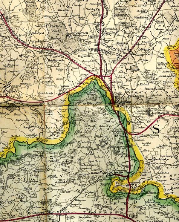
Cruchley’s
map showing position of Oxford ca 1880 at the end of the turnpike era.