
The Turnpike Roads
Creating a network of well-maintained roads
was one of the major achievements of 18th century
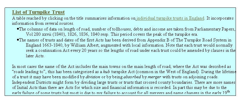
A list of English Turnpike trusts with details of their size and income is in an attached table (see sources and caveats in box below).
An overview of turnpike roads in particular
counties of
Documentary
material relating to individual turnpike trusts in each county can be reached
from these County pages.
However, the turnpikes were only one phase
in the development of a comprehensive road network in
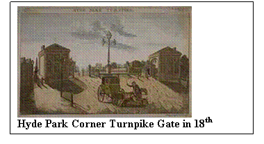
What Were Turnpikes?
A turnpike is literally a defensive frame
of pikes that can be turned to allow passage of horses, but in this context it
refers to a gate set across the road to stop carts until a toll was paid.
Empowering trustees to erect turnpike gates was the most successful mechanism
for ensuring that the costs of improvement and maintenance of a road was
financed by the beneficiaries. During the first seven decades of the 18th
century a comprehensive network of turnpike roads was created across
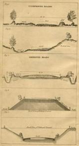
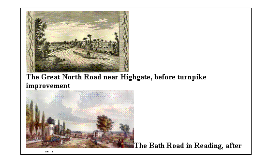
What did they achieve?
The turnpike trusts first stopped the rapid
deterioration in the condition of main roads and slowly began to build a
network of well maintained highways that allowed road transport to move more
efficiently and reliably. The money raised by mortgaging the future toll income
permitted substantial investment in the improvement of the drainage, gradients,
width and running surface of existing highways. Later it allowed the trusts to
build new sections of road to by-pass bad sections and to construct new
engineered structures such as embankments, cuttings and even bridges to provide
faster routes where horse power could be used more efficiently to haul
vehicles. Better roads led to better vehicles which horses pulled more
efficiently and at much faster speeds. Although heavy goods were still carried
more efficiently by water, road transport became the best means of carrying
goods and people rapidly and safely between the booming towns of late 18th
and early 19th century
How
to improve the road (ca 1830)
The End of the Turnpikes
Many turnpike trusts were wound up under General Acts of Parliament between 1873 and 1878. The transfer of resources and sale of assets to repay loans were supervised by the Local Government Board which acted as arbiter in the case of disputes. Toll-houses were sold, gates torn down and responsibility for the main roads passed to Highway Boards. Bond-holders were paid off with any residual funds, though some did not get a satisfactory return on their investment. For instance investors in the Harwell to Streatley Turnpike Trust were repaid less than a half of their capital and bondholders received less than a fifth of the face value of their investment in the Stokenchurch Trust. In contrast the Besselsleigh Trust was proud to handover the roads free of debt though some of the Highways Authorities who inherited responsibility for the road complained that they were in "a uniform (bad) state of repair throughout".
Under the Highways Act of 1878 all disturnpiked roads became "Main Roads" as did some ordinary highways. By the Local Government Act of 1888 the entire maintenance of main roads was thrown upon the County Councils.
Surviving Features
The pattern of our present road network
owes much to decisions taken by the turnpike trustees. Although the structure
of the roadway differs enormously from the gravel and stone surface of the
turnpike, the line of many main roads was set by the Turnpike Acts of the 18th
century. Some roads may have declined in status but most are still passable for
wheeled vehicles. The major exceptions are where military aerodromes were constructed
over the old roads. At Abingdon the Shippon road was cut, at Brize Norton the
Burford road was changed and at Benson the main Henley road was diverted closer
to
The revived
fortune of road transport is a story for the 20th century and required another
bold stroke of planning to break out of the restrictive pattern of existing
highways. The new A40 carried the main east/west road north of
If you have
questions or information relating to aspects of turnpikes or the people who
used these roads, you may contact Alan at rosevear1@aol.com.
There is a summary of information on turnpike
trusts in Wikipedia (http://en.wikipedia.org/wiki/Turnpike_trust)
with an entry starting;
Turnpike
trusts were bodies set up
by Act of Parliament, with powers to collect road tolls for
maintaining the principal highways in Britain during the eighteenth century and nineteenth century. At the peak in the 1830s,
over 1000 trusts administered around 30,000 miles of turnpike road in
TURNPIKE REFERENCES
|
Burke T. (1942) "Travel in Dodd, E.M. (1995) The Blythe Marsh to Thorpe Turnpike, N Staffs Journal of Field Studies 5, 1 Freeman M.J. (1979) "Turnpikes & their traffic; the example of southern Hampshire", Trans. Inst. Brit. Geogr. (NS) 4, 411-439. Hartmann C.H. (1927) "The Story of the Roads", pub. Routledge,
Hindle B.P. (1989) "Medieval Roads", pub. Shire Publications, Princes Risborough. Leighton A.C. (1972) "Transport & communication in early
medieval OMS (1977) "OMS Information Sheet 5. Turnpike Roads in Oxfordshire" Pawson E.J. (1977) "Transport and Economy", pub.
Academic Press, Phillips D. (1983) "The great road to Taylor C.C. (1979) "Roads and tracks of Timperley H.W. & Brill E. (1983) "Ancient trackways of Wright G.N. (1992) "Turnpike roads", pub. Shire Publications, Princes Risborough. |
Booklets on Turnpikes in the
This series of booklets covers
various aspects of the turnpike roads across
RUTV 1 & 2
concentrate on the history of the roads to the southwest of
RUTV 3 gives an overview of the road
network along the
RUTV 10 describes some of the roadside structures which the turnpike trustees created. The vehicles which provided transport services on the turnpikes are described in RUTV 11 and RUTV 12 traces the demise of the turnpikes following the building of the Great Western Railway.
RUTV 1; Ancient Tracks across the Vale of White Horse
RUTV 2; Ogilby's Road to Hungerford
RUTV 3; The Turnpike Network in the
RUTV 4; The Besselsleigh Turnpike
RUTV 5; The
Includes names of trustees and toll lessees.
RUTV 6;
Fyfield to
covers the turnpikes around Faringdon,
RUTV 7; Turnpike Roads through Abingdon
most material on the Henley & Dorchester Turnpike Trust
RUTV 8;
Turnpike Roads around
most material on the Stokenchurch Wheatley & Begbroke Turnpike Trust. Includes
names of trustees and toll lessees.
RUTV 9; The
King's Highway - Recorded journeys through the
based on the itineraries of the Plantagenet King?
RUTV 10; Milestones and Toll Houses on Old Turnpike Roads
includes illustrations of surviving items and a list of turnpike gate keepers,
RUTV 11; Coach and Waggon Services
on Roads in the
includes information on the individual coaches, and some material on the coachmen
RUTV 12; Response of Thames Valley Turnpikes to the coming of the Railway
concerned with the changes resulting from the building of Steventon, Didcot and
RUTV 13: Early Maps of the
This page created by Alan Rosevear 11th Jan 2008.
Minor edits 4th Febn 2009.