This trust, created in
1759, was responsible for the roads running into
Ref;
http://www.plymouthdata.info/Turnpike%20roads-Modbury.htm
3 Feb 1759 Modbury
Petition of the clergy, freeholders and principal inhabitants of Modbury and other parishes on Highway leading from Modbury towards Plymouth thru church town of Yelmpton , east end of Brixton church town and thence thu Plympton and village of Underwood to North end of Lincotta lane in Parish of Plympton St Mary many parts are narrow, much in decay an incommodious and dangerous for travellers, especially wheeled carriages in Winter season
6 mar 1759
Alderman Baker reported
Pet from inhabitants of Modbury, Ermington,
Kolbeton,
To prove Mr Robert Palmer jnr said is it is incommodious
;;;;;;;;;;;;;;;;;;;;;;;.
|
Modbury |
Modbury to
Plympton |
32 Geo2 c68 |
1759 |
|
|
Modbury |
|
21 Geo3 c84 |
1781 |
|
|
Modbury |
|
43 Geo3 c27 |
1803 |
|
|
Modbury |
New road
to Laira Bridge |
4 Geo4 c109 |
1823 |
|
|
Modbury |
|
6&7 Wil4 c48 |
1836 |
|
|
Modbury |
Expired |
|
1878 |
Nov 1878 |
Modbury 1803
An Act for continuing the Term, and altering
and enlarging the Powers of Two Acts, passed in the Thirty-second Year of the
Reign of His late Majesty, and The Twenty-first Year of the Reign of His
present Majesty, for repairing and widening the Road from Modbury through the
Town of Plympton, to the North End of Lincotta Lane, in the County of Devon.
[7th April 1803.]
Modbury 1823
An Act for more effectually making and
maintaining the Road from Modbury, through the Town of Plympton, to the North
End of Lincotta Lane, and from Modbury to within Four hundred Yards of the
Bridge over the Lary, and also a Road from Addistone Hill, in the Parish of
Holbeten, to the Totnes Road at Lady Down, in the Parish of Ugborough in the
County of Devon. [17th June 1823.]
And whereas the Trustees appointed in or by virtue of the said recited Acts have proceeded to put the same into Execution, and a considerable·Sum of Money hath been borrowed on the Credit of the Tolls by the said Acts granted; which still remains due and owing, and cannot be paid off or the said Road be effectually amended, improved, and kept in repair, unless the Powers and Authorities thereof are altered, amended, and enlarged ; and it is expedient that the Tolls granted by the said recited Acts should be increased : And whereas it is desirable that a new Road should be made from the present Modbury Road, at or near to a Place called Addistone Hill, in the Parish of Holbeton, to the Totnes Road at or near to a Place called Lady Down in the Parish of Ugborough, and also between Sakers Bridge Gate and the said new Road leading from Addistone Hill aforesaid to Ermington Lane, in order to open a direct Communication between the populous Towns situated in the South of Devon and the Town of Plymouth through a Line of Country comparatively free from Hills: And whereas it would be of the greatest public Utility to make another new Line of Road between the present Modbury Road at a Place called Kitley Hill in the Parish of Yealmton, by the Villages of Brixton and Elburton, and from thence to within Four hundred Yards of the Bridge over an Estuary of the Sea. called the Lary, in lieu of the present hilly and circuitous Road between Silver Bridge Gate and the Termination of the present Modbury Road at the North End of Linnacot Lane in the Parish of Plympton Saint Mary : ..May it therefore please Your Majesty that it may be enacted;
William Holberton of
There are 16 miles 1 furl 27 pl of road thru 7 parishes – all repaired
by the trustees (except those parts repaired by the county at Ermington Bridge
and Saker’s Bridge and Yealm Bridge, amounting to half a mile).
5 toll gates and 7 side bars (5 of which adjoin gates; the remaining 2
about 300yds from a gate)
The roads are stated to be in “good” condition – no part under
indictment for want of repair. The county road at Saker’s Bridge is complained
of by the public as being narrow.
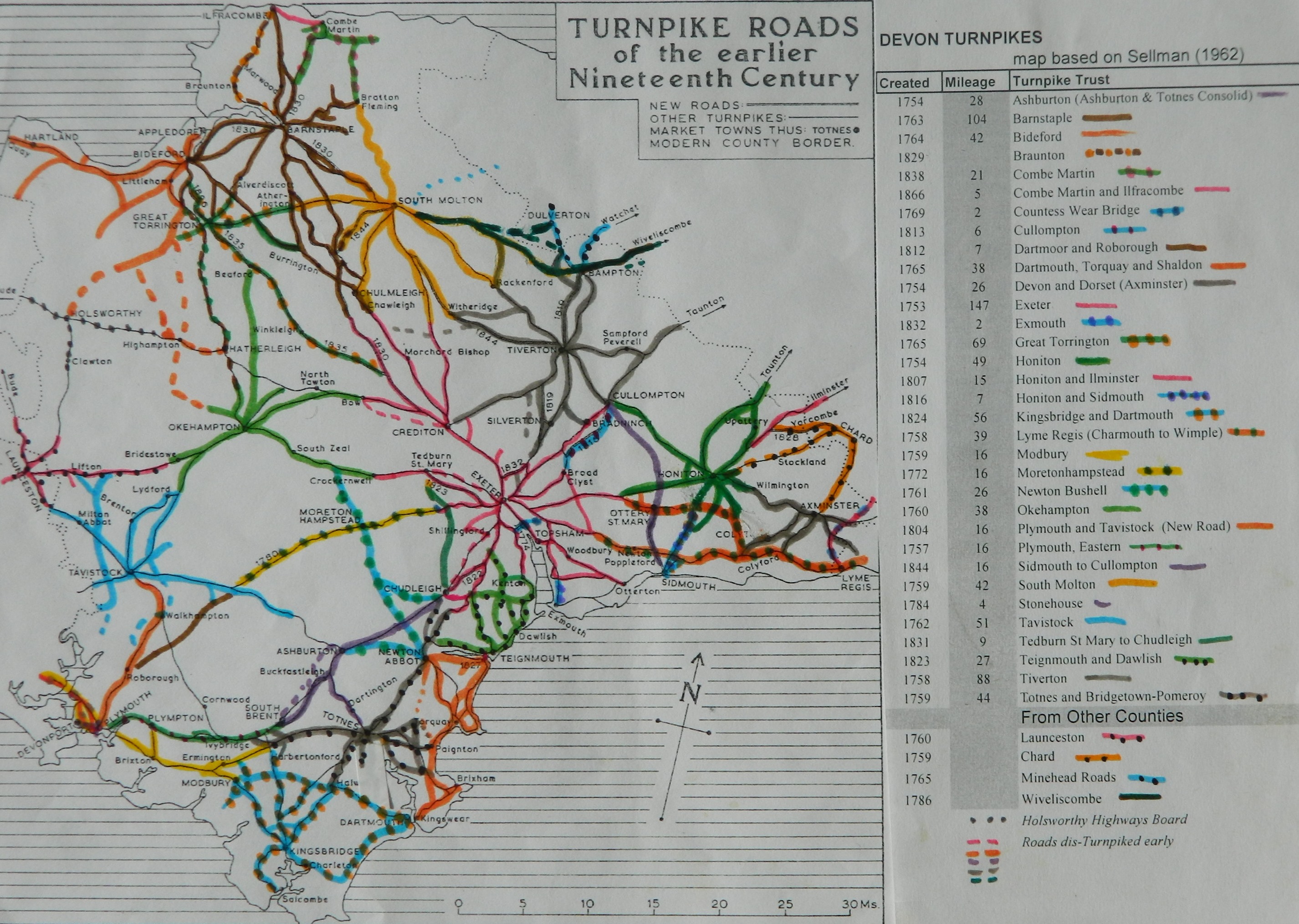
Click
here for a map
of Devon Turnpike Roads
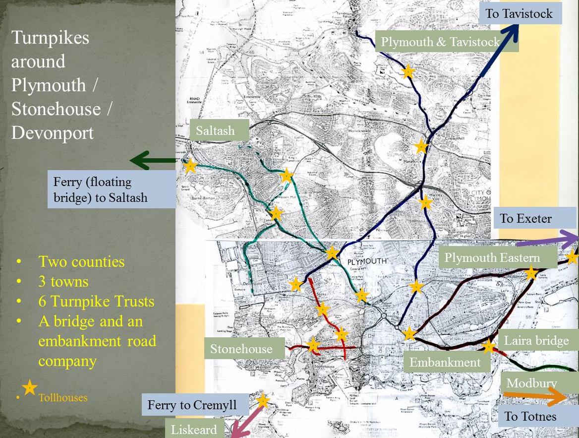
Click
here for a map of Plymouth Turnpike Roads
Click
here to return to Turnpikes
Home
Return
to Turnpikes in Devon general page
|
Road
Classification Number |
Route |
GATE NAME |
OS Grid Ref-
Prefi |
Easting |
Northing |
District |
Civil Parish |
Location (Name or
Number) |
Road or Street
(see across) |
Position |
Evidence |
Revised 23rd Sept
2013 |
erected by
(Turnpike Trust or Authority) |
Bibliographic
refs |
|
A3121 |
Totnes to
Plymouth |
Ermington |
SX |
63735 |
52839 |
DVSH |
ERMINGTON |
Toll
Cottage |
Totnes Road |
at jct with
Town Hill, in the bank |
OS 1st
Series; ; ; old Picture |
Modbury |
Jenkinson
T. & Taylor P. (2009), "The Toll-houses of South Devon", p51 |
|
|
A379 |
Plymouth to
Kingsbridge |
Sequers Bridge
(Sakers Bridge) or Goutsford |
SX |
631 |
519 |
DVSH |
MODBURY |
Sequers Bridge |
Goutsford Gate |
built ca 1823
demolished 1960s |
OS 1st Series; ;
Turnpike Trust Returns 1824; old Picture |
Modbury |
Jenkinson T.
& Taylor P. (2009), "The Toll-houses of South Devon", p52 |
|
|
A3121 |
Totnes to
Plymouth |
Ludbrook |
SX |
661 |
543 |
DVSH |
UGBOROUGH |
Ludbrook Gate,
Ludbrook, at jct with lane to Filham |
|
; ; ; |
Modbury |
Jenkinson T.
& Taylor P. (2009), "The Toll-houses of South Devon", p51; 1861
census |
||
|
A379 |
Plymouth to
Kingsbridge |
Yealm
Bridge |
SX |
59072 |
51956 |
DVSH |
YEALMPTON |
Yealm
Bridge Toll House, No. 161 |
Modbury
Road |
E side of
bridge at jct with lane to horse centre |
OS 1st
Series; Greenwood Devon (1827); Turnpike Trust Returns 1824; |
Modbury |
Jenkinson
T. & Taylor P. (2009), "The Toll-houses of South Devon", p50 |
|
|
A379 |
Plymouth to
Kingsbridge |
Yealm
Bridge Hut |
SX |
59320 |
52012 |
DVSH |
YEALMPTON |
roadside
shelter |
at Dunstone
Crossroads, E of the bridge and main toll house |
on a wide
grass verge |
; ; ; |
Modbury |
Jenkinson
T. & Taylor P. (2009), "The Toll-houses of South Devon", p50 |
|
|
A379 |
Plymouth to
Kingsbridge |
Brixton |
SX |
555 |
522 |
DVSH |
YEALMPTON |
Brixton village |
|
demolished early
1980s |
; Greenwood Devon
(1827); ; |
Modbury |
Jenkinson T.
& Taylor P. (2009), "The Toll-houses of South Devon", p49 |
|
|
A379 |
Plymouth to
Kingsbridge |
Silver Bridge |
SX |
562 |
520 |
DVSH |
YEALMPTON |
Silver Bridge
Lake, to E of Brixton |
was this replaced
by village TH |
|
; ; Turnpike
Trust Returns 1824; |
Modbury |
|
|
In the Milestone Society Database, 10
milestones are identified on the A3121, and A379, – most in a design known as Modbury Marker.
Based on Trust mileage, would expect 16.
(excluding notices of meetings and letting of tolls)
|
Notice
to renew and extend Act |
01-Sep |
1780 |
|
detail
of roads to be repaired |
19-Aug |
1802 |