Lyme Regis Turnpike Trust (Charmouth & Wimple) (updated 24th Sept
2013)
Formed as a Division
of the Lyme Regis Turnpike Trust (created in 1758). Its
primary responsibilities were for two branches of the
J House of Commons - Reports
6 Dec. 1757; Lyme Regis
Gents, clergy, freeholders and inhabitants of Lyme Regis Dorset and Devon, that High Road leading from the Almshouse at west end of Charmouth to and thru Lyme Regis and thru parishes of Uplyme, Axmouth, Culliford, in Parish of Culliford Seaton, and Hangman’s Stone, to east end of a lane called Radice or Viny Lane in Parish of Culliton, and from thence to Trowe in Parish of Salcombe (otherwise Salcombe Regis), Sidford in Parish of Sidbury, Sidmouth, Hardford, Newton Poppleford in Parish of Aylesbear to western side of Aylesbear Hill to meet Exeter Turnpike road
And from East end of Radice thru this lane and parishes of Battlesis, Roncombs Gurt, parts of Parish of Sidbury, and Ottery St Mary to Straitway Head (otherwise Stretwood Head) in Parish of Whimple
And from Ottery St Mary to the waypost in the Parish of Whimple
And from Lyme Regis to and thru Parish of Uplyme to the Waystone beyond Uplyme Hill;
Are in a ruinous condition, narrow in many places and very steep and uneven and by reason of the waters in the winter season unpassable at divers places and very dangerous to travellers cannot be repaired, widened by present methods.
9 Dec 1757;Lyme
Mr Tomas Fane reported – to support allegation Mr Benjamin Follett said roads are very narrow and in many places founderous and in winter season frequently overflowed rendered impassable
Joseph Cottarrall confirmed this and said
some of the roads open a communication to several large towns on the sea coast
and is the ancient road from Charmouth to
3rd
List of
Acts
|
Lyme Regis
(Charmouth to Wimple) |
|
31 Geo2 c43 |
1758 |
|
|
Lyme Regis
(Charmouth to Wimple) |
|
10 Geo3 c59 |
1770 |
|
|
Lyme Regis
(Charmouth to Wimple) |
|
39&40 Geo3 c28 |
1800 |
|
|
Lyme Regis
(Charmouth to Wimple) |
Creates into 2
Divisions |
1/2 Geo4 c108 |
1821 |
|
|
Lyme Regis
(Charmouth to Wimple) |
Extended by
continuation acts to 1855 |
18&19 Vic c87 |
1855 |
|
|
Lyme Regis
(Charmouth to Wimple) |
Expired |
40&41 Vic c64 |
1877 |
Nov 1877 |
Select Committee on State of Roads 1840
George
Hangeston of Lyme Regis (clerk to the Trust) reported;
There are 39 miles 25ch of road thru 16 parishes – all repaired by the
trustees except sections through Whimple and Ottery – and two miles in Uplyme
which has been abandoned in consequence of the new line of road being formed
some years past.
14 toll gates and 4 side bars
The roads are stated to be “in a tolerably good state of repair” – no
part under indictment for want of repair.
Report to Secretary of State
No. 8.—LYME REGIS ROADS.
The
existing Act for these roads (the lst & 2nd of George IV. cap. 108.) was passed in the year 1821 and repealed the
former Acts of the 3lst of George II., and the 10th and 40th of George
III. The term of the present Act would have expired with the session of 1842,
but has been extended by the several Turnpike
Acts Continuance Acts until the 1st day of November 1855.
The roads
belonging to this Trust were divided by the present Act into two districts,
called the " Lyme Regis Branch " and the " Crewkerne
Branch," of which separate accounts
have been kept of the income, expenditure, debts, &c. It therefore
appears desirable to state the particulars of each of these districts separately.
1.—the Lyme regis branch.
The roads
belonging to this branch are about 36 miles in length, and are repaired by the Trustees, excepting one mile and
a half situate in the Borough and Parish of Lyme Regis, and about 5
miles situated in the Town and Parish of Ottery St. Mary, which portions are repaired by the
respective parishes. There are ten
toll-gates and four bars on this branch. Dividing the road into two equal
portions, there are four toll-gates and three bars on one side called the Sidmouth or Western District, and five
toll-gates and one bar on the Lyme Regis or Eastern District. The former
district does not clear the gates on the latter,
and vice versa, but the gates on each district clear each other a distance
of about 14 miles. The remaining toll-gate is situated in a distinct locality,
and neither clears nor is cleared. The full rate of toll is levied on this branch, except for horses not drawing, which
are charged 1d. instead of 2d.
It appears
that in the year 1762 the sum of £4,000 was borrowed upon this
branch at £4.5 per cent, interest, of which the sum of £100 has been
paid off, leaving £3,900 due to 12 creditors. In or about the year 1824 the sum
of £2,300 was borrowed from the Exchequer
Bill Loan Office, the whole of which was
paid off by annual installments, which ended in the year 1843. In the year 1831
and subsequently, the sum of £2,750 was borrowed, the whole of which remains
due to 13 creditors, and bears interest at 5 per cent. Respecting the
sums borrowed in 1836 and 1840 the clerk has stated the following particulars
:— The sum of £350 was borrowed in the
year 1836 to pay a debt due to the
executors of the then late clerk, and the sum of £50 was raised by a
Deed poll in the year 1840, and paid to the late Henry John Henley, Esq., a
landowner, in part payment of balance due to him for a piece of land purchased
by the Trustees to widen a road.
The accounts show that the toll income became reduced considerably in
the year 1844, which was probably occasioned by the abolition
of the additional tolls, which
had been applied in aid of the payment of the Exchequer Loan. The toll income
in 1852 was stated at £442 9s. 4d. and in 1853 at £l,095 6s, 8d-which latter sum included the arrears which had
been unpaid in 1852, The funds have
been expended as under: in repairs of road ; in salaries (£67 2s. until 1845, £94 2s. in 1846, and now increased to £103
2s.) ; law charges (of large amount until 1848); interest
of debt; improvements (about £900 since 1839); debts paid off (installments to
the Exchequer Loan Office); and incidentals. For several years there was a balance due to the treasurer, but on the 31st
December 1853, there was a balance in hand sufficient to pay the arrears
of interest due at that date, £255 17s 6d
List of Roads
Charmouth Road; A3052 from the Almshouse at west end of Charmouth through Lyme Regis across the county boundary into Devon through Rousdon and Colyford (Culliford) to Hangman’s Stone, past Radice Lane jct and on to Trowe in Parish of Salcombe Regis, by Sidford, to the River Otter at Hardford, through Newton Poppleford to western side of Aylesbear Hill to meet the Exeter Turnpike Road (at crossroads with B3180 – Halfway House). (about 22 miles)
Straightway Head Road; UC Seaton Road (was B3174) from East end of Radice Lane (fork off Charmouth Road) through, Roncombe Gurt to Ottery St Mary and on B3174 to Straitway Head (otherwise Stretwood Head) in Parish of Whimple at jct with A30 to meet the Exeter Turnpike Road (about 12 miles)
|
|
|
|
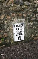
A typical Lyme Plate attached to a degraded
stone at Colyford |
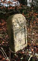
A typical milestone from which the Lyme Plate
has been taken. A legend has been cut into the recess at a later date |
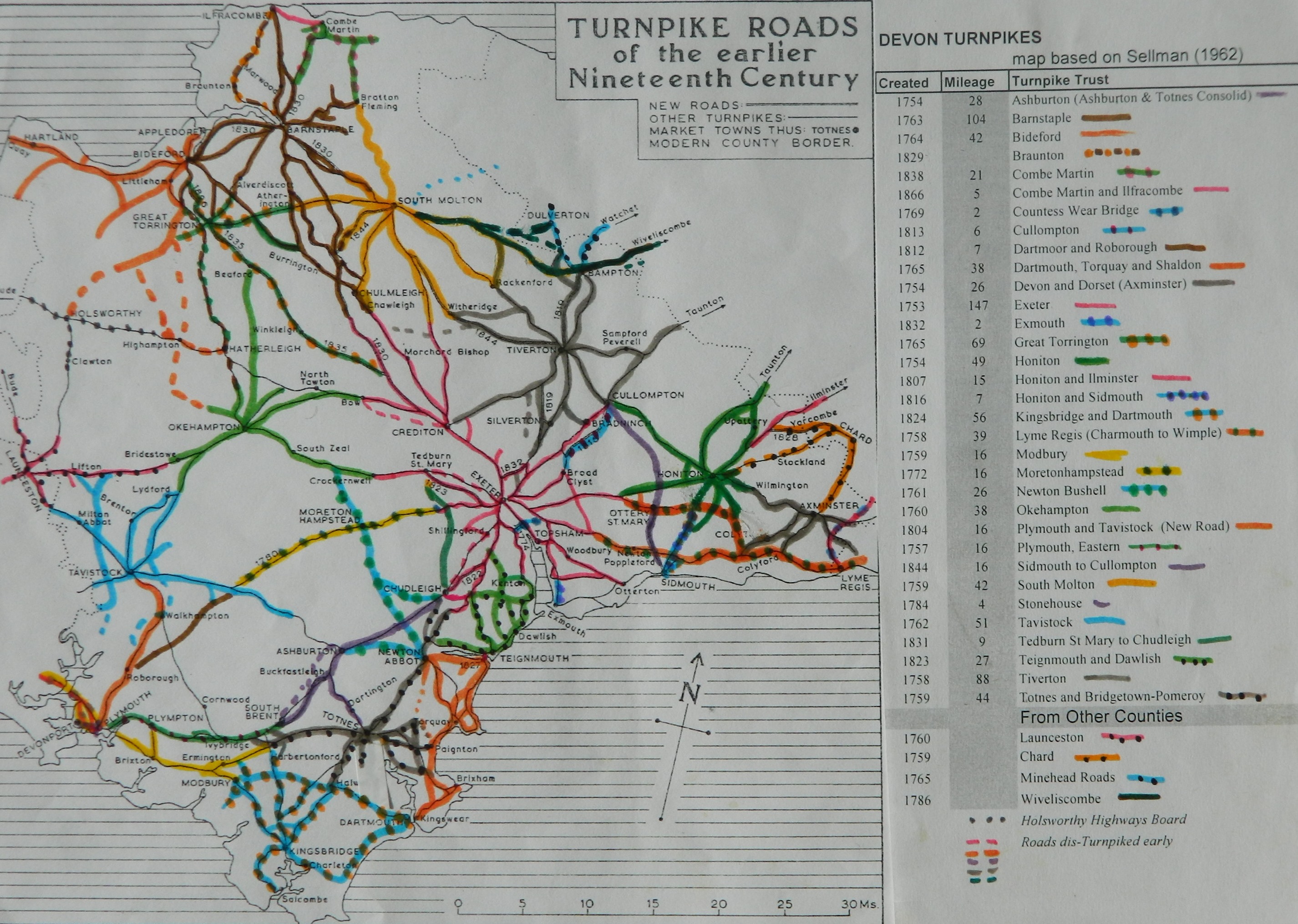
Click
here for a map
of Devon Turnpike Roads
Click
here to return to Turnpikes
Home
Return
to Turnpikes in Devon general page