Created in 1829 to
improve a short section of road west of
|
Braunton |
Initially road
west from new crossing of River Yeo in |
10 Geo4 c17 |
1829 |
|
|
Braunton |
Extension to
Ilfracombe |
4&5 Vic c102 |
1841 |
|
|
Braunton |
Expired |
40&41 Vic c64 |
1877 |
Nov 1878 |
Braunton 1829
An Act for making and maintaining a
making and maintaining of a Turnpike Road from the North End of the High Street of the Town of Barnstaple, over and through the Lands lying on the South Sides of the several Parishes of Pilton, Ashford, and Heanton Punchardon, and over and through a certain Part of the Parish of Braunton, partly along the present Highway, unto the Town or Village of Braunton in the County of Devon, and the building, erecting, and constructing a Bridge on the Line of such new Road across the River Yeo, at or near a Place called the Mill End Quay in Barnstaple aforesaid, will be of great Benefit and Convenience to the Owners and Occupiers of Estates., and also of Persons resident near to the Line of such new Road, and also of great public Utility, by opening a nearer, more level, and better Communication between the said Town of Barnstaple and the said Town or Village of Braunton.
Hugh Ballment of Barnstaple (clerk to the trust) reported
There are 5 miles 1 furl of road thru 4 parishes –the trustees repair
the road through Pilton but the remainder is repaired by the parishes
9 toll gates
The roads are stated to be in “decent” repair – no part under indictment
for want of repair.
Braunton Road; (this
replaced the old road built by the Barnstaple Trust in 1827) a new
Turnpike Road now the A361 from Mill End Quay Bridge to Braunton, through
Ashford, Heanton Punchardon (about 5 miles);
Braunton and Ilfracombe Road; a new Turnpike, now the A361, from Braunton through Georgeham, West Down,
Morthoe and Ilfracombe, (about 7 miles) This appears to have included the spur
down to Woolacombe station.
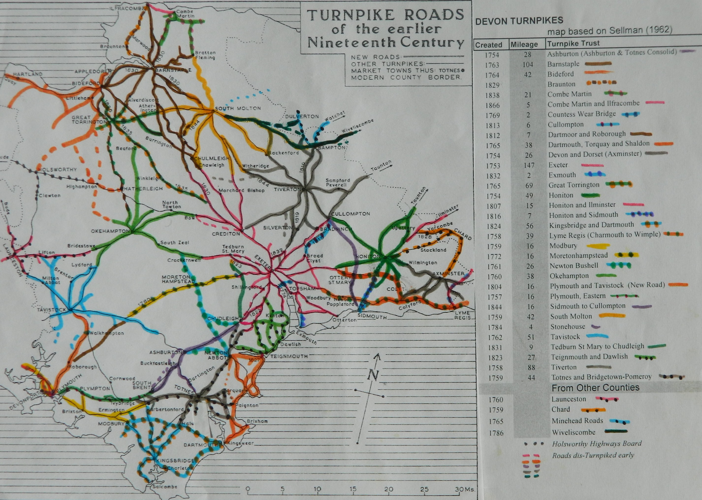
Click
here for a map
of Devon Turnpike Roads
Click
here to return to Turnpikes
Home
Return
to Turnpikes in Devon general page
|
Road
Classification Number |
Route |
GATE NAME |
OS Grid Ref-
Prefi |
Easting |
Northing |
District |
Civil Parish |
Location (Name or
Number) |
Road or Street
(see across) |
Position |
Evidence |
Revised 23rd Sept
2013 |
erected by
(Turnpike Trust or Authority) |
Bibliographic
refs |
|
A361 |
Barnstaple to
Braunton |
Mill End Quay |
SS |
556 |
335 |
DVND |
BARNSTAPLE |
crossing of River
Yeo |
|
|
OS 1st Series; ;
; |
Braunton |
|
|
|
A361 |
Barnstaple to
Braunton |
Pottington |
SS |
553 |
337 |
DVND |
BARNSTAPLE |
Pilton |
|
|
; ; ; |
Braunton |
Jenkinson T.
& Taylor P. (2010), "The Toll-houses of North Devon", p.54;
1871 census |
|
|
Berry Down |
SS |
571 |
438 |
DVND |
BERRYNARBOR |
Berry Down Cross |
|
|
; ; ; |
Braunton |
Jenkinson T.
& Taylor P. (2010), "The Toll-houses of North Devon", p.60;
1841 census |
|||
|
A361 |
Barnstaple to
Ilfracombe |
Corfe Green |
SS |
492 |
381 |
DVND |
BRAUNTON |
Knowle |
|
|
; ; ; |
Braunton |
Jenkinson T.
& Taylor P. (2010), "The Toll-houses of North Devon", p.57;
1871 census |
|
|
A361 |
Barnstaple to
Braunton |
Wrafton |
SS |
495 |
355 |
DVND |
HEANTON
PUNCHARDON |
Wrafton |
|
|
; ; ; |
Braunton |
|
|
|
A361 |
Barnstaple
to Ilfracombe |
Ilfracombe |
SS |
51510 |
47213 |
DVND |
ILFRACOMBE |
No 6 |
St.
Brannocks Road (was Vicarage Road) |
at narrow
section of road, S of Church Hill |
; ; toll
advert 1830, 1840; |
Braunton |
Jenkinson
T. & Taylor P. (2010), "The Toll-houses of North Devon", p.58;
1871 census |
|
|
B3343 |
Woolacombe
Road |
Borough
Corner |
SS |
48567 |
43924 |
DVND |
WEST DOWN |
Greenfield
Cottage |
Turnpike
Cross, Woolacombe Station Road |
at junction
close to old station |
; ; ; |
Braunton |
Jenkinson
T. & Taylor P. (2010), "The Toll-houses of North Devon", p.57;
1871 census |
Milestones
data with Barnstaple Trust
(excluding notices of meetings and letting of tolls)
|
new
road open |
30-Jan |
1845 |