This trust was created in 1763 to turnpike the highway from the mining areas around Redruth to the quays on the River Fal.
|
Penryn and
Redruth |
|
3 Geo3 c52 |
1763 |
|
|
Penryn and Redruth |
|
25 Geo3 c114 |
1785 |
|
|
Penryn and
Redruth |
|
47 Geo3 c43 |
1807 |
|
|
Penryn and
Redruth |
|
7&8 Geo4 c18 |
1827 |
|
|
Penryn and
Redruth |
|
12&13 Vic c44 |
1849 |
|
Redruth 1807
An Act to revive and continue the Term and Powers of Two Acts, of the Third
and Twenty-fifth Years of His present Majesty, for amending the Roads from
Penryn, in the
Roads leading from
John Rowe of Mylor nr
There are 8 miles 309 yds of road thru 6 parishes – all repaired by the
trustees
7 toll gates and a side chain bar
The roads are stated to be in “very good” condition – no part under
indictment for want of repair.
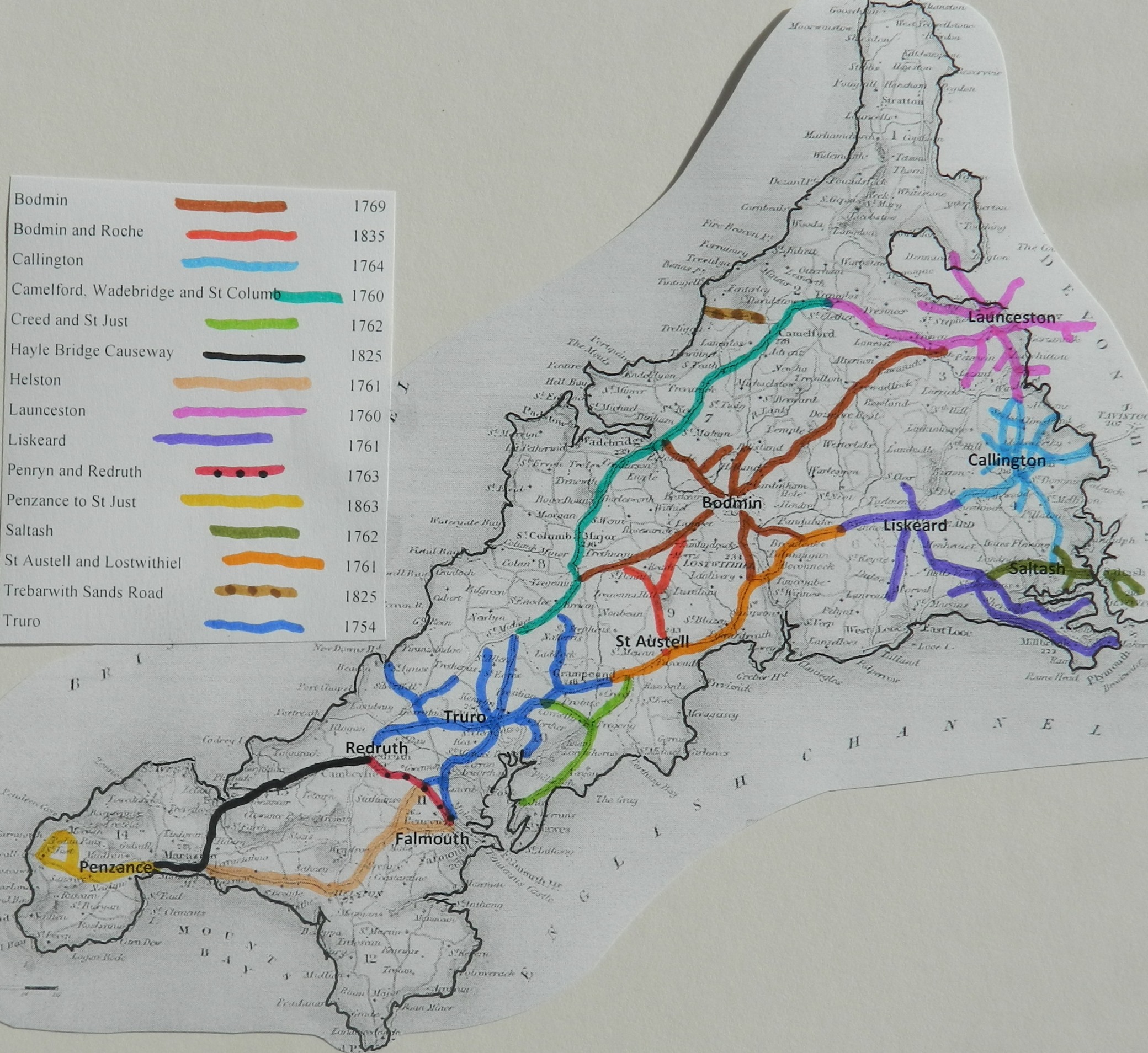
Click
here for a map
of Cornwall Turnpike Roads
Click
here to return to Turnpikes
Home
Return to Turnpikes in Cornwall general
page
|
Road
Classification Number |
Route |
GATE NAME |
OS Grid Ref-
Prefi |
Easting |
Northing |
District |
Civil Parish |
Location (Name or
Number) |
Road or Street
(see across) |
Position |
Evidence |
Revised 24th Sept
2013 |
erected by
(Turnpike Trust or Authority) |
Bibliographic
refs |
|
A393 |
Penryn to Redruth |
Comford |
SW |
734 |
399 |
CWCA |
GWENNAP |
Gwennap |
|
|
OS 1st Series; ;
; |
Penryn and
Redruth |
Taylor P. (2001),
"The Toll-houses of Cornwall", p39 |
|
|
A393 |
Penryn to Redruth |
Pellean Bar |
SW |
755 |
385 |
CWCA |
PERRANARWORTHAL |
Pelean Cross,
Ponsanooth |
|
|
; ; ; |
Penryn and
Redruth |
|
|
|
A393 |
Penryn to Redruth |
Terrell's |
SW |
701 |
414 |
CWKE |
REDRUTH |
|
|
|
; ; ; |
Penryn and
Redruth |
Taylor P. (2001),
"The Toll-houses of Cornwall", p38 |
|
|
B3298 |
Penryn to
Scorrier |
St Day |
SW |
733 |
427 |
CWKE |
ST DAY |
Toll
Cottage |
Little
Beside |
|
; ; ; |
Penryn and
Redruth |
- |
|
|
A393 |
Penryn to Redruth |
Bray's |
SW |
7582 |
3782 |
CWKE |
ST GLUVIAS |
Bray's |
Ponsanooth |
|
; ; ; |
Penryn and
Redruth |
Taylor P. (2001),
"The Toll-houses of Cornwall", p40 |
In the Milestone
Society Database, 3 are identified on A393, – in a Penryn Marker design. (based
on Trust mileage, expect 8 i.e. some side roads may have been included)