This trust was created in 1760 to turnpike
the main highway along the northern side of
|
Haleworthy |
Hallworthy,
Wadebridge, Mitchell |
33 Geo2 c42 |
1760 |
|
|
Haleworthy |
|
22 Geo3 c104 |
1782 |
|
|
Haleworthy |
|
43 Geo 3 c95 |
1803 |
|
|
Haleworthy |
|
6 Geo 4 c40 |
1825 |
|
|
Haleworthy |
|
1&2 Vic c6 |
1838 |
|
|
Haleworthy |
continuation |
38&39 Vic c194 |
1875 |
|
|
Haleworthy |
Expired |
|
1879 |
Nov 1879 |
Haleworthy 1803
An Act for further continuing the Term, and enlarging
the Powers, of an Act made in the Thirty-third Year of the Reign of His late
Majesty King George the Second, for repairing and widening the Roads from
Haleworthy in the Parish of Davidflow, in the County of Cornwall, to the East
End of Wadebridge, and from the West End of Wadebridge into and through the
Borough of Mitchell in the said County. [24th June 1803.]
Haleworthy 1825
An Act for more effectually repairing and
improving the Road leading from Haleworthy, in the Parish of Davidstow in the
Richard Symons of Wadebridge (clerk to the trust) reported
There are 33 and a half miles of road thru 10 parishes – all repaired by
the trustees
14 toll gates
The roads are stated to be in “pretty good” condition – no part under
indictment for want of repair.
Note that Launceston
style milestones are in place up to the western end of Davidstow parish (ie a
mile along the A39)
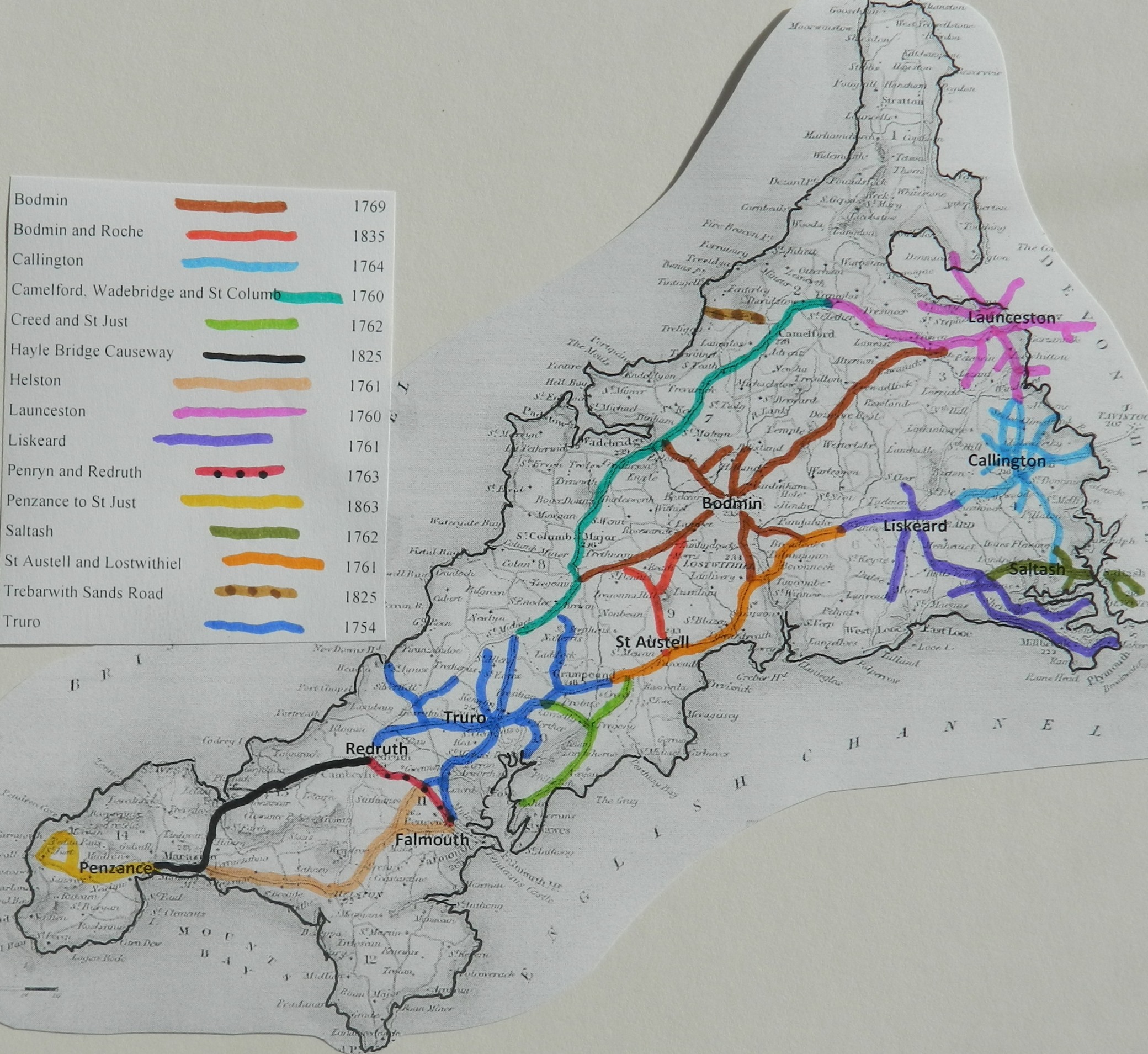
Click
here for a map
of Cornwall Turnpike Roads
Click
here to return to Turnpikes
Home
Return to Turnpikes in Cornwall general
page
|
Road
Classification Number |
Route |
GATE NAME |
OS Grid Ref-
Prefi |
Easting |
Northing |
District |
Civil Parish |
Location (Name or
Number) |
Road or Street
(see across) |
Position |
Evidence |
Revised 24th Sept
2013 |
|
A30 |
Wadebridge
to Mitchell |
Mitchell (1) |
SW |
8565 |
5444 |
CWCA |
ST NEWLYN EAST |
west of Mitchell, in an area altered by road
improvements, was a toll house that adjoined the former A30 |
demolished
between 1880 and 1907 |
|
; ; ; |
|
|
Wadebridge to
Mitchell |
Mitchell (2) |
SW |
8621 |
5464 |
CWCA |
ST NEWLYN EAST |
A house and gate
are recorded at this location on the St Newlyn East Tithe Map c1840. A
building, within the highway, is recorded on both the 1st and 2nd Edition
1:2500 OS maps c1880 and c1907 |
; ; ; |
||||
|
A39 |
Davidstow
to Wadebridge |
Haleworthy |
SX |
2 |
9 |
CWNC |
DAVIDSTOW |
|
|
|
; ; Turnpike
Trust Returns 1824; |
|
|
A39 |
Camelford
to Wadebridge |
Three Hole
Cross |
SX |
0119 |
7367 |
CWNC |
EGLOSHAYLE |
Three Hole
Cross |
Camelford
Road |
at country
crossroads, N of Wadebridge |
OS 1st
Series; ; Turnpike Trust Returns 1824; |
|
|
UC road
(was A39) |
Wadebridge
to St Columb |
St Breock
(Wadebridge) |
SW |
97181 |
72576 |
CWNC |
ST BREOCK |
Tollgate
House (the Roundhouse) |
Whitecross
Road |
on cut off
section of road opp. County Showground, just west of jct with B3314 down into
Wadebridge |
OS 1st
Series; ; Turnpike Trust Returns 1824; |
|
|
A39 |
Davidstow
to Wadebridge |
Treseat |
SX |
1958 |
8702 |
CWNC |
TRENEGLOS |
one mile east of
Halworthy |
|
|
; ; ; |
|
|
UC road |
Wadebridge
to Mitchell |
St Columb
Bridge |
SW |
91455 |
64003 |
CWRE |
ST COLUMB
MAJOR |
Toll House |
Bridge
Hill, on bridge over river |
has unusual
bay window pane |
; ; ; old
Picture |
|
|
UC road |
Wadebridge
to Mitchell |
St Columb |
SW |
91144 |
63227 |
CWRE |
ST COLUMB
MAJOR |
Toll House |
jct of Fair
Street, Newquay Street and Station Road |
; ; ; |
||
|
UC road |
Wadebridge
to Mitchell |
New Road |
SW |
91616 |
64045 |
CWRE |
ST COLUMB
MAJOR |
No. 39 |
New Road,
jct with Bridge |
The gable
has a small projecting bay that looks up and down the road. Toll house was
built at the same time as the "New Road |
; ; ; |
|
|
A30 |
Wadebridge
to Mitchell |
Fraddon |
SW |
912 |
580 |
CWRE |
ST ENODER |
Fraddon |
|
|
; ; Turnpike
Trust Returns 1824; |
|
In the Milestone
Society Database, 24 are identified on A39 – all in CAM Tombstone and St Columb
stone style. (based on Trust mileage, expect 36)